3D Structural Modelling and Restoration of a Deformed Alpine Karst Reservoir: Insights into the Groundwater Flows of the Dévoluy Massif (French Alpine Foreland)
Oriane Parizot, Nicolas Espurt, Benoît Viguier, Guillaume Duclaux, Alexandre Zappelli, Abdeltif Lahfid, Nathan Rispal, Ludovic Mocochain, Pierre Henry, Marianna Jagercikova, Philippe Audra, Bruno Arfib, Laurent Cadilhac
{"title":"3D Structural Modelling and Restoration of a Deformed Alpine Karst Reservoir: Insights into the Groundwater Flows of the Dévoluy Massif (French Alpine Foreland)","authors":"Oriane Parizot, Nicolas Espurt, Benoît Viguier, Guillaume Duclaux, Alexandre Zappelli, Abdeltif Lahfid, Nathan Rispal, Ludovic Mocochain, Pierre Henry, Marianna Jagercikova, Philippe Audra, Bruno Arfib, Laurent Cadilhac","doi":"10.1111/bre.70065","DOIUrl":null,"url":null,"abstract":"<p>In foreland fold-thrust belts, tectonically deformed aquifers remain underexplored, largely due to the complex architecture of their hydrogeological reservoirs. This limited understanding prevents the development of sustainable management policies to face the current decline in groundwater availability. In the southwestern Subalpine Chains, we characterised the structure of the folded Senonian karst aquifer of the Dévoluy Massif, which is transected by the Median Dévoluy Thrust. Using surface structural data, we performed an original 3D structural model of the massif. Quantitative analyses of this model indicate a total Senonian package volume of 114 km<sup>3</sup>, of which 25 km<sup>3</sup> lie below the elevation of Gillardes Spring, the main karst discharge. A structural restoration of the base of the Senonian indicates Alpine shortening of ~4.4 km in the southern part of the massif and ~1.2 km in the northern part. The deformation of the karst reservoir into two N-trending synclines, separated by the Median Dévoluy Thrust, is identified as a key control on the northward groundwater drainage pattern, culminating at Gillardes Spring. This 3D structural modelling approach also allowed for identification of suitable areas for the exploration of new deeper resources. Finally, this study highlights the potential of a hydrostructural approach and 3D structural modelling for assessing the hydrogeology in tectonically deformed karst reservoirs.</p>","PeriodicalId":8712,"journal":{"name":"Basin Research","volume":"37 5","pages":""},"PeriodicalIF":2.6000,"publicationDate":"2025-10-13","publicationTypes":"Journal Article","fieldsOfStudy":null,"isOpenAccess":false,"openAccessPdf":"https://onlinelibrary.wiley.com/doi/epdf/10.1111/bre.70065","citationCount":"0","resultStr":null,"platform":"Semanticscholar","paperid":null,"PeriodicalName":"Basin Research","FirstCategoryId":"89","ListUrlMain":"https://onlinelibrary.wiley.com/doi/10.1111/bre.70065","RegionNum":2,"RegionCategory":"地球科学","ArticlePicture":[],"TitleCN":null,"AbstractTextCN":null,"PMCID":null,"EPubDate":"","PubModel":"","JCR":"Q2","JCRName":"GEOSCIENCES, MULTIDISCIPLINARY","Score":null,"Total":0}
引用次数: 0
Abstract
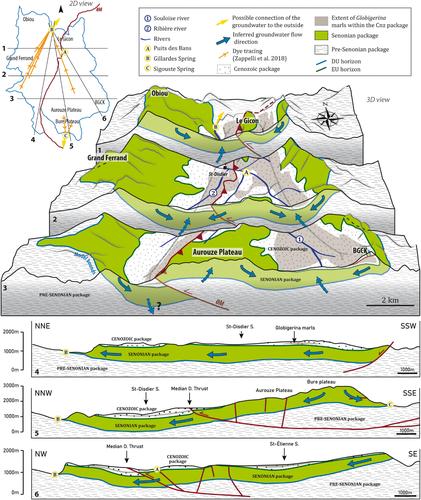
In foreland fold-thrust belts, tectonically deformed aquifers remain underexplored, largely due to the complex architecture of their hydrogeological reservoirs. This limited understanding prevents the development of sustainable management policies to face the current decline in groundwater availability. In the southwestern Subalpine Chains, we characterised the structure of the folded Senonian karst aquifer of the Dévoluy Massif, which is transected by the Median Dévoluy Thrust. Using surface structural data, we performed an original 3D structural model of the massif. Quantitative analyses of this model indicate a total Senonian package volume of 114 km3, of which 25 km3 lie below the elevation of Gillardes Spring, the main karst discharge. A structural restoration of the base of the Senonian indicates Alpine shortening of ~4.4 km in the southern part of the massif and ~1.2 km in the northern part. The deformation of the karst reservoir into two N-trending synclines, separated by the Median Dévoluy Thrust, is identified as a key control on the northward groundwater drainage pattern, culminating at Gillardes Spring. This 3D structural modelling approach also allowed for identification of suitable areas for the exploration of new deeper resources. Finally, this study highlights the potential of a hydrostructural approach and 3D structural modelling for assessing the hydrogeology in tectonically deformed karst reservoirs.
期刊介绍:
Basin Research is an international journal which aims to publish original, high impact research papers on sedimentary basin systems. We view integrated, interdisciplinary research as being essential for the advancement of the subject area; therefore, we do not seek manuscripts focused purely on sedimentology, structural geology, or geophysics that have a natural home in specialist journals. Rather, we seek manuscripts that treat sedimentary basins as multi-component systems that require a multi-faceted approach to advance our understanding of their development. During deposition and subsidence we are concerned with large-scale geodynamic processes, heat flow, fluid flow, strain distribution, seismic and sequence stratigraphy, modelling, burial and inversion histories. In addition, we view the development of the source area, in terms of drainage networks, climate, erosion, denudation and sediment routing systems as vital to sedimentary basin systems. The underpinning requirement is that a contribution should be of interest to earth scientists of more than one discipline.

 求助内容:
求助内容: 应助结果提醒方式:


