Spatial correlation network, driving factors and planning application of land green use efficiency in Zhejiang Province, China
IF 5.6
Q1 ENVIRONMENTAL SCIENCES
引用次数: 0
Abstract
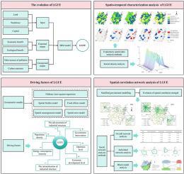
Exploring land green use efficiency (LGUE) is crucial for optimizing land allocation and spatial planning, especially in land-constrained regions. Using 2001–2023 panel data from 90 counties of Zhejiang Province, this study constructs a LGUE spatial correlation matrix using a modified gravity model, applies social network analysis (SNA) to examine LGUE spatial correlation network (SCN) evolution, and uses spatial Durbin model to identify drivers. The findings reveal that: (1) LGUE exhibits a "first rise then decline" trend with spatial polarization. (2) The SCN optimized, correlation pairs increasing from 70 in 2001 to 254 in 2023, forming a Hangzhou-Ningbo-Zhoushan radial pattern. (3) Network structure featured "stable connectivity but loose cohesion": connectivity remained 1, density 0.12–0.17, efficiency down to 0.7794 from 2001 to 2023, while hierarchical degree up to 0.3045 post-2015, (4) 90 counties were classified into four functional blocks. (5) Core areas concentrated in four metropolitan zones (Hangzhou, Ningbo, Jinhua, Yiwu), aligning with the "dual-core, quad-polar" plan, but key areas like Yiwu and Ninghai remained peripheral, with "multiple clusters" yet to form. (6) Econometric results show economic development, government intervention, openness, and population density positively impacted LGUE, while energy consumption intensity, industrial structure advancement, and rationalization had negative effects, with significant heterogeneity between core and peripheral zones. This study deepens the understanding of LGUE's spatiotemporal and network traits, constructs a systematic measurement framework, and provides targeted support for enhancing LGUE and optimizing land planning in Zhejiang Province and other similar regions.
浙江省土地绿色利用效率空间关联网络、驱动因素及规划应用
探索土地绿色利用效率(LGUE)对于优化土地配置和空间规划至关重要,特别是在土地约束地区。利用2001-2023年浙江省90个县域的面板数据,采用修正的重力模型构建LGUE空间相关矩阵,应用社会网络分析(SNA)分析LGUE空间相关网络(SCN)演化,并利用空间Durbin模型识别驱动因素。结果表明:(1)LGUE随空间极化呈先上升后下降的趋势;(2) SCN优化,相关对由2001年的70对增加到2023年的254对,形成杭州-宁波-舟山辐射状格局。(3)网络结构呈现“连通性稳定,内聚性松散”的特征,2001 - 2023年连通性为1,密度为0.12-0.17,效率降至0.7794,2015年后分级度达到0.3045;(4)90个县域划分为4个功能块。(5)核心区集中在杭州、宁波、金华、义乌四个大都市区,符合“双核四极”格局,但义乌、宁海等重点区域仍处于外围,“多集群”尚未形成。(6)经济发展程度、政府干预程度、开放度和人口密度对城市生态环境变化具有正向影响,而能源消费强度、产业结构先进性和合理化对城市生态环境变化具有负向影响,且核心区与外围区差异显著。本研究深化了对LGUE时空和网络特征的认识,构建了系统的测度框架,为浙江省等类似地区加强LGUE和优化土地规划提供了有针对性的支持。
本文章由计算机程序翻译,如有差异,请以英文原文为准。
求助全文
约1分钟内获得全文
求助全文
来源期刊

Environmental and Sustainability Indicators
Environmental Science-Environmental Science (miscellaneous)
CiteScore
7.80
自引率
2.30%
发文量
49
审稿时长
57 days
 求助内容:
求助内容: 应助结果提醒方式:


