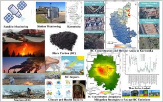
Retrieval of satellite-derived black carbon concentration and mitigation approaches for Karnataka, India
IF 3.7
2区 环境科学与生态学
Q2 ENVIRONMENTAL SCIENCES
引用次数: 0
Abstract
Black carbon (BC) is a short-lived climate pollutant that adversely impacts human health, regional air quality, and climate. Accurate monitoring of its spatiotemporal variability remains a challenge due to limited ground-based observations. This study develops a high-resolution (1 × 1 km) dataset of annual BC columnar concentrations across Karnataka, India, for 2018–2024 by combining satellite retrievals of aerosol optical depth (AOD), carbon monoxide (CO), and nitrogen dioxide (NO2) with ground-based BC observations using regression modeling. Results show a consistent rise in annual BC concentrations of 0.2–0.5 μg/m3 per year, except in 2020 when emissions decreased due to pandemic-related restrictions. District-level analysis identifies Kalaburagi, Raichur, Ballari, Bengaluru Urban, and Vijayanagara as major BC hotspots. Sectoral contributions indicate Industry (46.4 %) and Road Transport (39.8 %) as dominant sources, with smaller shares from Residential (6.8 %), Forest Fires (3.5 %), Stubble Burning (2.4 %), and miscellaneous activities (1.2 %). Model evaluation demonstrates moderate agreement between estimated BC and independent datasets, with R2 = 0.65 and RMSE = 0.49 against ground-based measurements, and coefficient of determination (R2) = 0.57 and Root Mean Square Error (RMSE) = 0.66 compared to Modern-Era Retrospective Analysis for Research and Applications (MERRA-2) reanalysis data for 2024. The high-resolution BC maps and hotspot and sectoral analyses provide improved spatial detail compared to reanalysis products or chemical transport models. These results highlight the growing BC b urden in Karnataka, the need for targeted mitigation in industrial and transport sectors, and the value of satellite-based approaches in supporting evidence-based air quality and climate policies.
印度卡纳塔克邦卫星获取的黑碳浓度和减缓方法
黑碳是一种短期的气候污染物,对人类健康、区域空气质量和气候产生不利影响。由于地面观测有限,对其时空变异性的准确监测仍然是一个挑战。本研究利用回归模型,将卫星反演的气溶胶光学深度(AOD)、一氧化碳(CO)和二氧化氮(NO2)与地面观测数据相结合,开发了2018-2024年印度卡纳塔克邦每年BC柱状浓度的高分辨率(1 × 1 km)数据集。结果显示,除了2020年由于与大流行有关的限制措施而排放量下降外,BC的年浓度每年持续上升0.2-0.5 μg/m3。地区级分析确定卡拉布拉吉、雷丘尔、巴拉里、班加罗尔市区和维贾耶那加拉是主要的卑诗省热点地区。行业贡献表明,工业(46.4%)和公路运输(39.8%)是主要来源,其次是住宅(6.8%)、森林火灾(3.5%)、残茬燃烧(2.4%)和其他活动(1.2%)。模型评估表明,估算BC与独立数据集之间存在适度的一致性,与地面测量值相比,R2 = 0.65, RMSE = 0.49;与2024年现代研究与应用回顾性分析(MERRA-2)再分析数据相比,决定系数(R2) = 0.57,均方根误差(RMSE) = 0.66。与再分析产品或化学运输模型相比,高分辨率的BC地图、热点和部门分析提供了更好的空间细节。这些结果突出了卡纳塔克邦日益增长的二氧化碳负担、工业和运输部门有针对性地减缓的必要性,以及基于卫星的方法在支持基于证据的空气质量和气候政策方面的价值。
本文章由计算机程序翻译,如有差异,请以英文原文为准。
求助全文
约1分钟内获得全文
求助全文
来源期刊
Atmospheric Environment
环境科学-环境科学
CiteScore
9.40
自引率
8.00%
发文量
458
审稿时长
53 days
期刊介绍:
Atmospheric Environment has an open access mirror journal Atmospheric Environment: X, sharing the same aims and scope, editorial team, submission system and rigorous peer review.
Atmospheric Environment is the international journal for scientists in different disciplines related to atmospheric composition and its impacts. The journal publishes scientific articles with atmospheric relevance of emissions and depositions of gaseous and particulate compounds, chemical processes and physical effects in the atmosphere, as well as impacts of the changing atmospheric composition on human health, air quality, climate change, and ecosystems.
 求助内容:
求助内容: 应助结果提醒方式:


