Characteristics and Health Risk Assessment of Groundwater Metal(loid)s in Different Geomorphological Units of the Coal-Fired Power Cluster in the “Ji”-Shaped Bend of the Yellow River
IF 7.3
2区 环境科学与生态学
Q1 ENVIRONMENTAL SCIENCES
引用次数: 0
Abstract
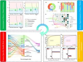
Groundwater metal(loid)s and associated health risks across geomorphic units in the Yellow River Ji-bend coal-fired power cluster are of growing concern. We profiled metal(loid)s in groundwater from 34 wells spanning hilly, piedmont-alluvial, and Yellow River alluvial units; applied self-organizing map (SOM) clustering to delineate pollution patterns; apportioned sources with APCS–MLR; and quantified source-specific human health risk using Monte Carlo simulation (MCS). The aquifer is generally weakly alkaline and overall metal(loid)s concentrations are low; however, the alluvial plain shows localized enrichment of arsenic (As) and manganese (Mn), with levels exceeding those in the hilly unit. Using the Heavy Metal Pollution Index (HPI), Nemerow Index (NI), and Contamination Degree (CD), 35.3% and 8.8% of samples were classified as moderate and high pollution, respectively, with pronounced spatial heterogeneity. APCS–MLR attributes approximately 45% of the total mass to geogenic sources, followed by industrial, traffic, and agricultural inputs. Monte Carlo simulation (MCS) identified As as the dominant health-risk driver, with the carcinogenic risk for adults (2.32 × 10⁻⁴) exceeding the acceptable threshold (1 × 10⁻⁴), while the non-carcinogenic risk is generally higher in children (HQ = 3.31) than in adults (HQ = 2.36). Source-specific risk apportionment indicates that >80% of total risk is attributable to geogenic sources, dominated by As. The framework supports risk-based zoning and management by linking spatial patterns, sources, and health risk across geomorphic units.
黄河“吉”弯不同地貌单元燃煤电厂群地下水金属形态特征及健康风险评价
黄河吉弯煤电集群各地貌单元地下水金属(样态)及其相关健康风险日益受到关注。我们对34口井的地下水中的金属(样态)进行了剖面分析,这些井横跨丘陵、山前冲积和黄河冲积单元;应用自组织图(SOM)聚类描述污染模式;APCS-MLR分配源;并使用蒙特卡罗模拟(MCS)量化特定源的人类健康风险。含水层一般呈弱碱性,总金属(类)浓度较低;然而,冲积平原显示局部富集砷(As)和锰(Mn),其含量超过丘陵单元。利用重金属污染指数(HPI)、Nemerow指数(NI)和污染程度(CD),分别有35.3%和8.8%的样本被划分为中度和重度污染,且空间异质性显著。APCS-MLR将大约45%的总质量归因于地质来源,其次是工业、交通和农业投入。蒙特卡罗模拟(Monte Carlo simulation, MCS)发现As是主要的健康风险驱动因素,成人的致癌风险(2.32 × 10⁻⁴)超过可接受阈值(1 × 10⁻⁴),而儿童的非致癌风险(HQ = 3.31)普遍高于成人(HQ = 2.36)。源特异性风险分配表明,80%的总风险可归因于地质源,以a类为主。该框架通过将各地貌单元的空间格局、来源和健康风险联系起来,支持基于风险的分区和管理。
本文章由计算机程序翻译,如有差异,请以英文原文为准。
求助全文
约1分钟内获得全文
求助全文
来源期刊
Environmental Pollution
环境科学-环境科学
CiteScore
16.00
自引率
6.70%
发文量
2082
审稿时长
2.9 months
期刊介绍:
Environmental Pollution is an international peer-reviewed journal that publishes high-quality research papers and review articles covering all aspects of environmental pollution and its impacts on ecosystems and human health.
Subject areas include, but are not limited to:
• Sources and occurrences of pollutants that are clearly defined and measured in environmental compartments, food and food-related items, and human bodies;
• Interlinks between contaminant exposure and biological, ecological, and human health effects, including those of climate change;
• Contaminants of emerging concerns (including but not limited to antibiotic resistant microorganisms or genes, microplastics/nanoplastics, electronic wastes, light, and noise) and/or their biological, ecological, or human health effects;
• Laboratory and field studies on the remediation/mitigation of environmental pollution via new techniques and with clear links to biological, ecological, or human health effects;
• Modeling of pollution processes, patterns, or trends that is of clear environmental and/or human health interest;
• New techniques that measure and examine environmental occurrences, transport, behavior, and effects of pollutants within the environment or the laboratory, provided that they can be clearly used to address problems within regional or global environmental compartments.
 求助内容:
求助内容: 应助结果提醒方式:


