Integrating seismicity parameter analysis and gravity anomaly characterization to enhance the accuracy of earthquake hazard assessment: a case study in Cenderawasih Bay, Indonesia
Richard Lewerissa, Sismanto, Jan Mrlina, Laura A. S. Lapono
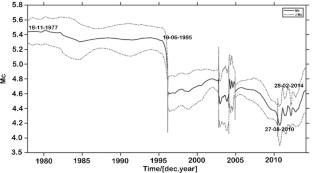
{"title":"Integrating seismicity parameter analysis and gravity anomaly characterization to enhance the accuracy of earthquake hazard assessment: a case study in Cenderawasih Bay, Indonesia","authors":"Richard Lewerissa, Sismanto, Jan Mrlina, Laura A. S. Lapono","doi":"10.1007/s10950-025-10311-1","DOIUrl":null,"url":null,"abstract":"<div><p>In Cenderawasih Bay, Papua, we improved the assessment of earthquake hazards by integrating seismic parameter analysis with gravity anomaly data. This region, which is known for its seismic activity and complex tectonic structures, offers an ideal setting for disaster risk-mitigation studies. In eastern Indonesia, tectonic plate convergence involves several microplates, creating deformation zones with arc-continent collisions, subduction, shear faults, strike-slip faults, and extensional faults. Our study examined the relationship between earthquake activity and gravity anomalies to enhance the understanding of seismic activity distribution in the Cenderawasih Bay region. Seismicity parameters were analyzed using the IRIS Earthquake Catalog, with aftershocks and foreshocks removed through Reasenberg declustering to focus on independent events. The average values for the seismicity parameters, specifically the magnitudes of completeness (<i>M</i><sub>c</sub>), a, and b, were 4.5, 7.3, and 0.95, respectively, indicating significant tectonic activity. Gravity anomalies were analyzed using a two-dimensional radial power spectrum and three-dimensional Euler deconvolution, which resulted in an estimated depth range for the gravity anomaly source between 15 and 33 km. The results demonstrate that seismic activity is primarily concentrated in the northern region and along the main fault lines of Cenderawasih Bay. There is a correlation between the seismicity parameter <i>b</i>-value and variations in gravity anomalies, with low <i>b</i>-values associated with low to moderate gravity anomalies in regions of high crustal pressure. In contrast, elevated <i>b</i>-values are associated with significant gravity anomalies in low-pressure regions. The seismicity parameter <i>a</i>-value was low to moderate, suggesting tectonic activity. High values correlate with significant gravity anomalies, and the inverse is true. Integrating seismicity analysis with gravity anomaly characterization provides insights into the earthquake distribution in Cenderawasih Bay. This methodological approach not only improves the accuracy of earthquake hazard assessments in the region, but also aids effective disaster risk mitigation.</p></div>","PeriodicalId":16994,"journal":{"name":"Journal of Seismology","volume":"29 4","pages":"903 - 931"},"PeriodicalIF":2.0000,"publicationDate":"2025-07-03","publicationTypes":"Journal Article","fieldsOfStudy":null,"isOpenAccess":false,"openAccessPdf":"","citationCount":"0","resultStr":null,"platform":"Semanticscholar","paperid":null,"PeriodicalName":"Journal of Seismology","FirstCategoryId":"89","ListUrlMain":"https://link.springer.com/article/10.1007/s10950-025-10311-1","RegionNum":4,"RegionCategory":"地球科学","ArticlePicture":[],"TitleCN":null,"AbstractTextCN":null,"PMCID":null,"EPubDate":"","PubModel":"","JCR":"Q3","JCRName":"GEOCHEMISTRY & GEOPHYSICS","Score":null,"Total":0}
引用次数: 0
Abstract
In Cenderawasih Bay, Papua, we improved the assessment of earthquake hazards by integrating seismic parameter analysis with gravity anomaly data. This region, which is known for its seismic activity and complex tectonic structures, offers an ideal setting for disaster risk-mitigation studies. In eastern Indonesia, tectonic plate convergence involves several microplates, creating deformation zones with arc-continent collisions, subduction, shear faults, strike-slip faults, and extensional faults. Our study examined the relationship between earthquake activity and gravity anomalies to enhance the understanding of seismic activity distribution in the Cenderawasih Bay region. Seismicity parameters were analyzed using the IRIS Earthquake Catalog, with aftershocks and foreshocks removed through Reasenberg declustering to focus on independent events. The average values for the seismicity parameters, specifically the magnitudes of completeness (Mc), a, and b, were 4.5, 7.3, and 0.95, respectively, indicating significant tectonic activity. Gravity anomalies were analyzed using a two-dimensional radial power spectrum and three-dimensional Euler deconvolution, which resulted in an estimated depth range for the gravity anomaly source between 15 and 33 km. The results demonstrate that seismic activity is primarily concentrated in the northern region and along the main fault lines of Cenderawasih Bay. There is a correlation between the seismicity parameter b-value and variations in gravity anomalies, with low b-values associated with low to moderate gravity anomalies in regions of high crustal pressure. In contrast, elevated b-values are associated with significant gravity anomalies in low-pressure regions. The seismicity parameter a-value was low to moderate, suggesting tectonic activity. High values correlate with significant gravity anomalies, and the inverse is true. Integrating seismicity analysis with gravity anomaly characterization provides insights into the earthquake distribution in Cenderawasih Bay. This methodological approach not only improves the accuracy of earthquake hazard assessments in the region, but also aids effective disaster risk mitigation.
期刊介绍:
Journal of Seismology is an international journal specialising in all observational and theoretical aspects related to earthquake occurrence.
Research topics may cover: seismotectonics, seismicity, historical seismicity, seismic source physics, strong ground motion studies, seismic hazard or risk, engineering seismology, physics of fault systems, triggered and induced seismicity, mining seismology, volcano seismology, earthquake prediction, structural investigations ranging from local to regional and global studies with a particular focus on passive experiments.
 求助内容:
求助内容: 应助结果提醒方式:


