Forest expansion and glacial retreat in the Central Himalaya indicated by past observations and future projections
Q2 Environmental Science
引用次数: 0
Abstract
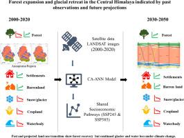
Land use and land cover (LULC) changes, driven by climate variability and human activity, are increasingly threatening the ecological stability of the Himalaya, yet their long-term dynamics remain poorly understood. We address this gap by analyzing past LULC transitions and projecting future changes in the Annapurna Conservation Area from 2000 to 2050. The study area covers 7629 km2, considerable elevational variation (800 to >8000 m), and variable precipitation regimes (300 to 3500 mm yr-1). We evaluated LULC changes over two decades (2000 - 2020) based on Landsat data and simulate future patterns for 2030 and 2050 using the Cellular Automata – Artificial Neural Networks (CA–ANN) model, integrating spatial drivers and climate data. For the year 2000, a maximum likelihood supervised classification indicated that forest covered 10%, settlement 2%, barren land 65%, snow/glacier 15%, cropland 6%, and waterbody 2% of the area. In the following two decades, forest first declined (-1.2%) and then strongly increased (+3%), settlement area doubled, and cropland was lost. Snow/glacier cover (-1.7%) and waterbody (-2%) declined significantly, while barren land expanded. Under both Shared Socioeconomic Pathways (SSP245 and SSP585), projections suggest continued forest (+4.2 to +4.3%) and settlement (+1.5% to +1.7%) increase and ongoing declines in snow/glacier (-4.7 to -4.9%), waterbody (-0.4%), and cropland (-0.6 to -0.7%) by 2050. These findings highlight the strong human and climate-driven transformations in the region, underscoring the urgency of actions towards climate protection and sustainable resource stewardship for ecological stability in the Himalaya.
过去的观测和未来的预测表明,喜马拉雅中部的森林扩张和冰川退缩
在气候变率和人类活动的驱动下,土地利用和土地覆盖(LULC)的变化正日益威胁着喜马拉雅地区的生态稳定,但对其长期动态却知之甚少。我们通过分析过去的LULC变化并预测2000年至2050年安纳普尔纳保护区的未来变化来解决这一差距。研究区面积7629 km2,海拔高度变化较大(800 ~ 8000m),降水量变化较大(300 ~ 3500mm /年)。利用元胞自动机-人工神经网络(CA-ANN)模型,综合空间驱动因素和气候数据,评估了2000 - 2020年20年的土地利用价值变化,并模拟了2030年和2050年的未来格局。2000年,最大似然监督分类表明,森林覆盖率为10%,定居点占2%,荒地占65%,雪/冰川占15%,农田占6%,水体占2%。在随后的20年里,森林面积先减少(-1.2%),然后急剧增加(+3%),定居面积增加了一倍,耕地减少。雪/冰川覆盖(-1.7%)和水体(-2%)明显下降,而荒地面积扩大。在共享社会经济路径(SSP245和SSP585)下,预测表明,到2050年,森林(+4.2至+4.3%)和定居点(+1.5%至+1.7%)持续增加,雪/冰川(-4.7至-4.9%)、水体(-0.4%)和农田(-0.6至-0.7%)持续减少。这些发现突出了该地区人类和气候驱动的强烈变化,强调了采取行动保护气候和可持续资源管理以促进喜马拉雅地区生态稳定的紧迫性。
本文章由计算机程序翻译,如有差异,请以英文原文为准。
求助全文
约1分钟内获得全文
求助全文
来源期刊

Environmental Challenges
Environmental Science-Environmental Engineering
CiteScore
8.00
自引率
0.00%
发文量
249
审稿时长
8 weeks
 求助内容:
求助内容: 应助结果提醒方式:


