Use of geochemical tracers to determine the sources for Riverine sediment with different sizes in a forest-agricultural watershed, northern Iran
IF 5.6
Q1 ENVIRONMENTAL SCIENCES
引用次数: 0
Abstract
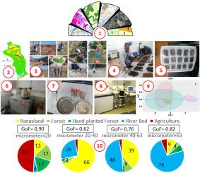
Because sediment sources, topography, and runoff vary, sediments generated in different parts of a watershed differ in size and properties, which affects the transport of various elements and contaminants. However, the variability of sediment particle size originating from various sources has not yet been considered. Therefore, the current research aimed to identify and separate sediment sources with different sizes of 0–2000 μm in the Kasilian representative watershed in Northern Iran. In this research, 40 soil samples were taken from different sediment sources of natural forest (10), hand planted forest (4), rangeland (14), and agricultural lands (8). In addition, 4 samples of suspended sediments were taken during two rainfall events in two monitoring stations of MS1 and MS2 in the middle and outlet of the studied watershed, respectively. In addition, four samples of fine-grained bed sediment were taken upstream of the river to determine the river bed's contribution as a sediment source. Then, the sediments were separated into four size classes of <20, 20–40, 40–63, and >63 μm. To select the optimal tracers for sediment fingerprinting, statistical analyses, including range tests, Kruskal-Wallis, and discriminant function analysis, were used, and finally, sediment sourcing was performed for each sediment size class using the FingerPro package in R software. The results showed that in both monitoring stations and two rainfall events, with the increase in sediment particle size from <20 to >63 μm, the mean contribution of river bed in sediment yield increases from ⁓4 to ⁓70 % and decreases from ⁓24 to ⁓4 %, respectively. Although the contribution of agricultural lands in <20-μm sediments was 45 % and 49 % in MS1 and MS2, respectively, its contribution in >20-μm sediments was insignificant. In MS1, the contribution of rangelands in sediment yield decreases with the increase in the size of the sediment particles. However, due to the location of a large part of the rangelands in the vicinity of the outlet of the watershed, its contribution to MS2 does not show a clear trend with the increase in the size of the sediment particles. This research provides a clear picture of the sediment transport processes of different sizes in the watershed to be used in soil conservation plans.
利用地球化学示踪剂确定伊朗北部森林农业流域不同大小河流沉积物的来源
由于沉积物来源、地形和径流的变化,流域不同地区产生的沉积物在大小和性质上存在差异,这影响了各种元素和污染物的输送。然而,不同来源沉积物粒度的可变性尚未得到考虑。因此,本研究旨在识别和分离伊朗北部Kasilian代表性流域0 ~ 2000 μm不同大小的沉积物源。本研究共采集了40份土壤样本,分别取自天然林(10份)、人工人工林(4份)、牧场(14份)和农用地(8份)的不同沉积物来源。此外,在研究流域中部和出水口MS1和MS2两个监测站的两次降雨事件中,分别采集了4个悬浮沉积物样本。此外,在河流上游采集了4个细粒河床沉积物样本,以确定河床作为泥沙源的贡献。然后,将沉积物划分为<;20、20 - 40、40-63和>;63 μm 4个粒径级。为了选择最佳的沉积物指纹示踪剂,使用了统计分析,包括范围测试、Kruskal-Wallis和判别函数分析,最后使用R软件中的FingerPro包对每种沉积物粒度进行沉积物源分析。结果表明:在两个降雨事件中,随着泥沙粒径从20 μm增加到63 μm,河床对产沙的平均贡献分别从⁓4%增加到⁓70%,从⁓24%减少到⁓4%;农田对20 μm沉积物的贡献在MS1和MS2中分别为45%和49%,但在20 μm沉积物中的贡献不显著。在MS1中,草地对产沙量的贡献随着泥沙颗粒大小的增加而减小。然而,由于大部分牧场位于流域出水口附近,其对MS2的贡献随着泥沙颗粒大小的增加并没有明显的趋势。该研究为土壤保持规划提供了不同尺度的流域输沙过程的清晰图像。
本文章由计算机程序翻译,如有差异,请以英文原文为准。
求助全文
约1分钟内获得全文
求助全文
来源期刊

Environmental and Sustainability Indicators
Environmental Science-Environmental Science (miscellaneous)
CiteScore
7.80
自引率
2.30%
发文量
49
审稿时长
57 days
 求助内容:
求助内容: 应助结果提醒方式:


