Quantifying seepage dynamics in a real-scale levee using time-lapse 3D ERT and novel spatiotemporal metrics
IF 8.4
1区 工程技术
Q1 ENGINEERING, GEOLOGICAL
引用次数: 0
Abstract
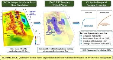
Aging levees face high failure risks due to undetected subsurface defects and undocumented construction, which complicates condition assessments. In this study, time-lapse 3D electrical resistivity tomography (ERT) was integrated with geotechnical and piezometric data to quantitatively assess the seepage dynamics in a real-scale levee under controlled flood conditions over 15 days. Four novel metrics were introduced: the detection rate (DR), saturation advance rate (SAR), total saturation period (TSP), and leakage persistence index (LPI). Results revealed two distinct seepage patterns across the levee sections. The levee crest showed rapid preferential wetting (DR = ∼1.34 m/day) and persistent saturation (LPI = 5.00–8.00). In contrast, the protected side exhibited delayed ingress (∼12 days), slower advance (DR ∼0.79 m/day), and prolonged saturation (TSP up to 15 days, LPI = 1.88). The ERT-derived water levels were highly precise, with a mean absolute percentage error (MAPE) of ≤1.88 % compared to piezometer data. This study presents a reproducible metric-based framework that transforms ERT from qualitative imaging into an actionable tool for early warning and proactive flood-risk management in levees.
利用时移三维ERT和新的时空度量量化实尺度堤防渗流动力学
由于未被发现的地下缺陷和未记录的施工,老化堤坝面临着很高的破坏风险,这使得状况评估变得复杂。在这项研究中,将延时三维电阻率层析成像(ERT)与岩土和压电测量数据相结合,定量评估了在15天的控制洪水条件下实际规模堤防的渗流动态。引入了四个新指标:检出率(DR)、饱和提前率(SAR)、总饱和周期(TSP)和泄漏持久性指数(LPI)。结果揭示了两种不同的渗流模式。堤峰表现出快速优先润湿(DR = ~ 1.34 m/d)和持续饱和(LPI = 5.00-8.00)。相比之下,受保护侧表现出延迟进入(~ 12天)、缓慢前进(DR ~ 0.79 m/天)和延长饱和(TSP长达15天,LPI = 1.88)。ert得出的水位高度精确,与压力表数据相比,平均绝对百分比误差(MAPE)≤1.88%。本研究提出了一个可重复的基于度量的框架,将ERT从定性成像转变为一种可操作的工具,用于早期预警和防洪堤的主动洪水风险管理。
本文章由计算机程序翻译,如有差异,请以英文原文为准。
求助全文
约1分钟内获得全文
求助全文
来源期刊

Engineering Geology
地学-地球科学综合
CiteScore
13.70
自引率
12.20%
发文量
327
审稿时长
5.6 months
期刊介绍:
Engineering Geology, an international interdisciplinary journal, serves as a bridge between earth sciences and engineering, focusing on geological and geotechnical engineering. It welcomes studies with relevance to engineering, environmental concerns, and safety, catering to engineering geologists with backgrounds in geology or civil/mining engineering. Topics include applied geomorphology, structural geology, geophysics, geochemistry, environmental geology, hydrogeology, land use planning, natural hazards, remote sensing, soil and rock mechanics, and applied geotechnical engineering. The journal provides a platform for research at the intersection of geology and engineering disciplines.
 求助内容:
求助内容: 应助结果提醒方式:


