Evaluating the potential of very high-resolution satellite data for the enhanced estimation of rice aboveground biomass by combining spectral and spatial information
IF 8.9
1区 农林科学
Q1 AGRICULTURE, MULTIDISCIPLINARY
引用次数: 0
Abstract
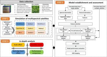
Monitoring aboveground biomass (AGB) using high spatial and temporal resolution remote sensing data is important for smart agriculture. Significant technological advances have been made in developing satellites with very high spatial resolution, delivering a promising avenue for vegetation observations. However, the high costs and limited revisit periods of high-resolution satellites hinder their widespread use, leaving the feasibility of combining vegetation indices (VIs) and textures derived from satellite images for AGB estimation uncertain and the quantitative improvements achieved by incorporating textures into estimation unclear. Airborne hyperspectral imaging with high spectral and spatial resolution offers a fresh opportunity to simulate the satellite imaging process objectively and realistically across both spectral and spatial dimensions. The study first evaluated the potential benefits of combining textures and VIs derived from different high-resolution satellites to enhance AGB retrieval. Rice samples and UAV hyperspectral data were collected throughout the rice growth cycle over three consecutive years. Each hyperspectral image was resampled in spectral and spatial dimensions to simulate nine multispectral satellites with sub-meter spatial resolution (WorldView-3, WorldView-2, GeoEye-1, SuperView-1C, GaoFen-2, Beijing-2, Jilin-1, GeoSat-2, KomPast-2). VIs, textures, and their combinations were employed to establish AGB models for the pre-heading, post-heading, and the entire growth stage, respectively. The results showed that combining VIs and textures always achieved the greatest rice AGB estimations, with the integration of multiple satellite data always yielding the best outcomes (overall validation rRMSE ≤ 0.35). For the texture-based monitoring, the impact of satellite spatial resolution was more pronounced on influencing the estimation effectiveness than spectral bands. The monitoring accuracy of rice AGB demonstrated a nonlinear decreasing trend as the spatial resolution dropped, and combining VIs and textures mitigated the negative impact of reduced spatial resolution on the monitoring accuracy of rice AGB. The combination of VIs and textures showed a compensatory effect and combining VIs and textures derived from red-edge band could offset the impact of the reduced spatial resolution on AGB estimation. The involvement of textures in modelling exerted an overall bigger impact on rice AGB estimation than the inclusion of red-edge variables. Satellites with higher spatial resolution and a red-edge band always performed the best in AGB estimation. This study facilitates the optimization of sensor design and farmland management.
评价高分辨率卫星数据结合光谱和空间信息增强水稻地上生物量估算的潜力
利用高时空分辨率遥感数据监测地上生物量(AGB)对智慧农业具有重要意义。在开发高空间分辨率卫星方面取得了重大技术进步,为植被观测提供了一条有希望的途径。然而,高分辨率卫星的高成本和有限的重审周期阻碍了它们的广泛使用,使得将卫星图像的植被指数(VIs)和纹理相结合用于AGB估算的可行性不确定,并且通过将纹理纳入估算所实现的定量改进也不清楚。高光谱和高空间分辨率的航空高光谱成像为客观、真实地模拟卫星成像过程提供了新的机会。该研究首先评估了结合不同高分辨率卫星的纹理和VIs来增强AGB检索的潜在效益。在连续三年的水稻生长周期中收集水稻样品和无人机高光谱数据。对每张高光谱图像进行光谱和空间采样,模拟9颗亚米空间分辨率的多光谱卫星(WorldView-3、WorldView-2、GeoEye-1、SuperView-1C、高分-2、北京-2、吉林-1、GeoSat-2、kompass -2)。采用VIs、织构及其组合分别建立了抽穗前、抽穗后和整个生育期的AGB模型。结果表明,VIs和纹理相结合的水稻AGB估计效果最好,而多卫星数据相结合的AGB估计效果最好(总体验证rRMSE≤0.35)。对于基于纹理的监测,卫星空间分辨率对估算效果的影响比光谱波段更明显。随着空间分辨率的降低,水稻AGB监测精度呈非线性下降趋势,VIs和纹理的结合缓解了空间分辨率降低对水稻AGB监测精度的负面影响。视觉和纹理的结合具有补偿效应,视觉和红边纹理的结合可以抵消空间分辨率降低对AGB估计的影响。纹理建模对水稻AGB估计的总体影响大于红边变量。空间分辨率越高、红边频带越宽的卫星对AGB的估计效果越好。该研究有助于传感器设计的优化和农田管理。
本文章由计算机程序翻译,如有差异,请以英文原文为准。
求助全文
约1分钟内获得全文
求助全文
来源期刊

Computers and Electronics in Agriculture
工程技术-计算机:跨学科应用
CiteScore
15.30
自引率
14.50%
发文量
800
审稿时长
62 days
期刊介绍:
Computers and Electronics in Agriculture provides international coverage of advancements in computer hardware, software, electronic instrumentation, and control systems applied to agricultural challenges. Encompassing agronomy, horticulture, forestry, aquaculture, and animal farming, the journal publishes original papers, reviews, and applications notes. It explores the use of computers and electronics in plant or animal agricultural production, covering topics like agricultural soils, water, pests, controlled environments, and waste. The scope extends to on-farm post-harvest operations and relevant technologies, including artificial intelligence, sensors, machine vision, robotics, networking, and simulation modeling. Its companion journal, Smart Agricultural Technology, continues the focus on smart applications in production agriculture.
 求助内容:
求助内容: 应助结果提醒方式:


