Hari S Iyer, Seigi Karasaki, Li Yi, Yulin Hswen, Peter James, Trang VoPham
{"title":"Harnessing Geospatial Artificial Intelligence (GeoAI) for Environmental Epidemiology: A Narrative Review.","authors":"Hari S Iyer, Seigi Karasaki, Li Yi, Yulin Hswen, Peter James, Trang VoPham","doi":"10.1007/s40572-025-00497-4","DOIUrl":null,"url":null,"abstract":"<p><strong>Purpose of review: </strong>Geospatial analysis is an essential tool for research on the role of environmental exposures and health, and critical for understanding impacts of environmental risk factors on diseases with long latency (e.g. cardiovascular disease, dementia, cancers) as well as upstream behaviors including sleep, physical activity, and cognition. There is emerging interest in leveraging machine learning and artificial intelligence (AI) for environmental epidemiology research. In this review, we provide an accessible overview of recent advances.</p><p><strong>Recent findings: </strong>There have been two major recent shifts in geospatial data types and analytic methods. First, novel methods for statistical prediction, combining geospatial analysis with machine learning and artificial intelligence (GeoAI), allow for scalable geospatial exposure assessment within large population health databases (e.g. cohorts, administrative claims). Second, the widespread adoption of smartphones and wearables with global positioning systems and other sensors has allowed for passive data collection from people, and when combined with geographic information systems, enables exposure assessment at finer spatial scales and temporal resolution than ever before. Illustrative examples include refining models for predicting outdoor air pollution exposure, characterizing populations susceptible to water pollution, and use of deep learning to classify Street View image-derived measures of greenspace. While these tools and approaches may facilitate more rapid, higher quality objective exposure measures, they pose challenges with respect to participant privacy, representativeness of collected data, and curation of high quality validation sets for training of GeoAI algorithms. GeoAI approaches are beginning to be used for environmental exposure assessment and behavioral outcome ascertainment with higher spatial and temporal precision than before. Epidemiologists should continue to apply critical assessment of measurement accuracy and design validity when incorporating these new tools into their work.</p>","PeriodicalId":10775,"journal":{"name":"Current Environmental Health Reports","volume":"12 1","pages":"34"},"PeriodicalIF":9.1000,"publicationDate":"2025-09-26","publicationTypes":"Journal Article","fieldsOfStudy":null,"isOpenAccess":false,"openAccessPdf":"https://www.ncbi.nlm.nih.gov/pmc/articles/PMC12474636/pdf/","citationCount":"0","resultStr":null,"platform":"Semanticscholar","paperid":null,"PeriodicalName":"Current Environmental Health Reports","FirstCategoryId":"3","ListUrlMain":"https://doi.org/10.1007/s40572-025-00497-4","RegionNum":2,"RegionCategory":"医学","ArticlePicture":[],"TitleCN":null,"AbstractTextCN":null,"PMCID":null,"EPubDate":"","PubModel":"","JCR":"Q1","JCRName":"PUBLIC, ENVIRONMENTAL & OCCUPATIONAL HEALTH","Score":null,"Total":0}
引用次数: 0
Abstract
Purpose of review: Geospatial analysis is an essential tool for research on the role of environmental exposures and health, and critical for understanding impacts of environmental risk factors on diseases with long latency (e.g. cardiovascular disease, dementia, cancers) as well as upstream behaviors including sleep, physical activity, and cognition. There is emerging interest in leveraging machine learning and artificial intelligence (AI) for environmental epidemiology research. In this review, we provide an accessible overview of recent advances.
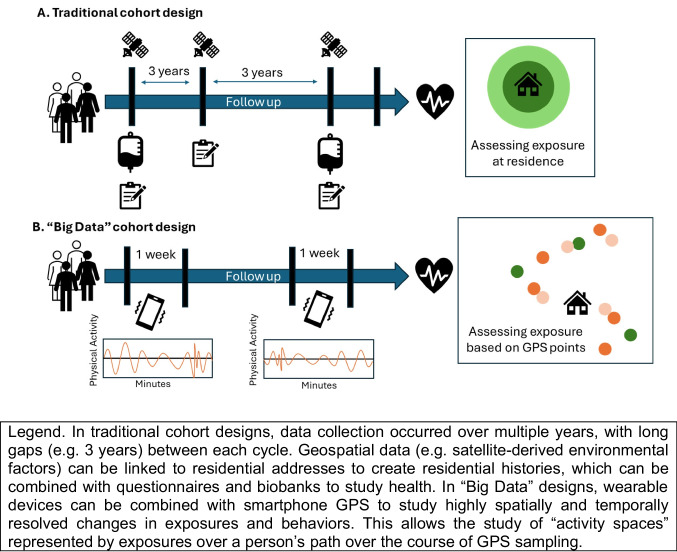
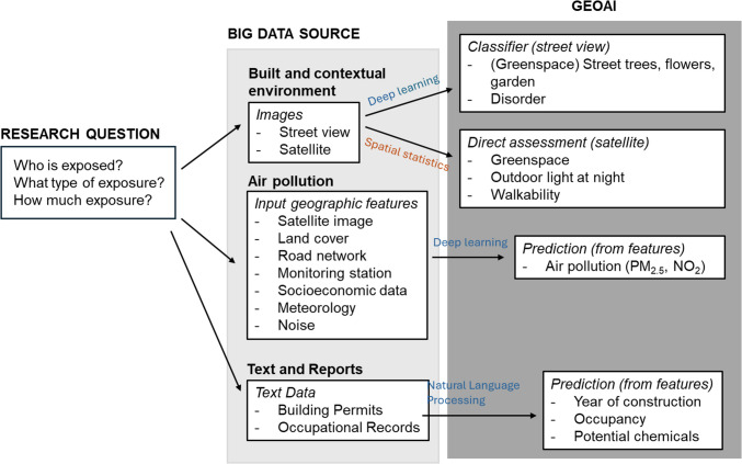
Recent findings: There have been two major recent shifts in geospatial data types and analytic methods. First, novel methods for statistical prediction, combining geospatial analysis with machine learning and artificial intelligence (GeoAI), allow for scalable geospatial exposure assessment within large population health databases (e.g. cohorts, administrative claims). Second, the widespread adoption of smartphones and wearables with global positioning systems and other sensors has allowed for passive data collection from people, and when combined with geographic information systems, enables exposure assessment at finer spatial scales and temporal resolution than ever before. Illustrative examples include refining models for predicting outdoor air pollution exposure, characterizing populations susceptible to water pollution, and use of deep learning to classify Street View image-derived measures of greenspace. While these tools and approaches may facilitate more rapid, higher quality objective exposure measures, they pose challenges with respect to participant privacy, representativeness of collected data, and curation of high quality validation sets for training of GeoAI algorithms. GeoAI approaches are beginning to be used for environmental exposure assessment and behavioral outcome ascertainment with higher spatial and temporal precision than before. Epidemiologists should continue to apply critical assessment of measurement accuracy and design validity when incorporating these new tools into their work.
期刊介绍:
Current Environmental Health Reports provides up-to-date expert reviews in environmental health. The goal is to evaluate and synthesize original research in all disciplines relevant for environmental health sciences, including basic research, clinical research, epidemiology, and environmental policy.
 求助内容:
求助内容: 应助结果提醒方式:


