{"title":"Geological heterogeneity and hydrological dynamics impact on triggered earthquake genesis in Deccan basaltic terrain of western India","authors":"Kondarathi Aruna Kumari, Lagudu Surinaidu, Yedavally Srinu, Kalpna Gahalaut","doi":"10.1007/s11600-025-01604-7","DOIUrl":null,"url":null,"abstract":"<div><p>Reservoir triggered seismicity (RTS) have been documented at about 700 locations worldwide, with the Koyna-Warna region in Western India hosted the largest triggered earthquake of magnitude 6.3. Despite substantial work has been done to understand the genesis of triggered earthquakes around Koyna-Warna reservoirs, most of the research has been limited to the immediate areas of the reservoirs. In this study, we expand the investigation to encompass a broader area, aiming to explore the impact of geological heterogeneity and groundwater storage anomalies derived from GRACE satellite data on earthquake occurrence in the region. Utilising 30-m resolution digital elevation model, we extracted lineaments and generated lineament density and trend maps. Analysis reveals a total of 927 lineaments spanning 33.73 km, with shorter lineaments comprising 70% of the total count. Lineament density ranges from 0 to 1.8 km/km<sup>2</sup>, indicating varying degrees of rock fracturing, with densities of 0.6–1.20 km/km<sup>2</sup> and 0.4–0.6 km/km<sup>2</sup> indicate high and moderate levels. Dominant lineament trends are observed in the N-S, NNW-SSE and WNW-ESE directions. Good correlation between lineament density, and earthquake occurrence is observed which is further validated from groundwater anomaly.</p></div>","PeriodicalId":6988,"journal":{"name":"Acta Geophysica","volume":"73 4","pages":"3431 - 3440"},"PeriodicalIF":2.1000,"publicationDate":"2025-05-25","publicationTypes":"Journal Article","fieldsOfStudy":null,"isOpenAccess":false,"openAccessPdf":"","citationCount":"0","resultStr":null,"platform":"Semanticscholar","paperid":null,"PeriodicalName":"Acta Geophysica","FirstCategoryId":"89","ListUrlMain":"https://link.springer.com/article/10.1007/s11600-025-01604-7","RegionNum":4,"RegionCategory":"地球科学","ArticlePicture":[],"TitleCN":null,"AbstractTextCN":null,"PMCID":null,"EPubDate":"","PubModel":"","JCR":"","JCRName":"","Score":null,"Total":0}
引用次数: 0
Abstract
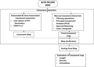
Reservoir triggered seismicity (RTS) have been documented at about 700 locations worldwide, with the Koyna-Warna region in Western India hosted the largest triggered earthquake of magnitude 6.3. Despite substantial work has been done to understand the genesis of triggered earthquakes around Koyna-Warna reservoirs, most of the research has been limited to the immediate areas of the reservoirs. In this study, we expand the investigation to encompass a broader area, aiming to explore the impact of geological heterogeneity and groundwater storage anomalies derived from GRACE satellite data on earthquake occurrence in the region. Utilising 30-m resolution digital elevation model, we extracted lineaments and generated lineament density and trend maps. Analysis reveals a total of 927 lineaments spanning 33.73 km, with shorter lineaments comprising 70% of the total count. Lineament density ranges from 0 to 1.8 km/km2, indicating varying degrees of rock fracturing, with densities of 0.6–1.20 km/km2 and 0.4–0.6 km/km2 indicate high and moderate levels. Dominant lineament trends are observed in the N-S, NNW-SSE and WNW-ESE directions. Good correlation between lineament density, and earthquake occurrence is observed which is further validated from groundwater anomaly.
期刊介绍:
Acta Geophysica is open to all kinds of manuscripts including research and review articles, short communications, comments to published papers, letters to the Editor as well as book reviews. Some of the issues are fully devoted to particular topics; we do encourage proposals for such topical issues. We accept submissions from scientists world-wide, offering high scientific and editorial standard and comprehensive treatment of the discussed topics.

 求助内容:
求助内容: 应助结果提醒方式:


