Building a high-resolution seismic impedance model via application of a novel grid conversion technique: implications for gas reservoirs
Abstract
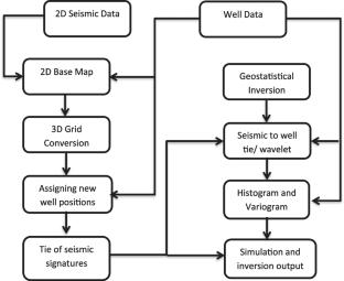
The characterization of thin-bedded reservoirs is quite a challenging task, particularly as the reservoir thickness is below the seismic resolution limit. Geostatistical inversion efficiently integrates different datasets to create a high-resolution impedance model for improved characterization of the thin-bedded reservoirs. However, the optimal utilization of geostatistical inversion necessitates the availability of 3D seismic data. This study presents a novel approach for converting 2D seismic lines into a 3D grid, enabling the application of geostatistical inversion techniques. Different seismic features within the target interval (Lower Goru Formation) are correlated to investigate the credibility of the applied technique. Subsequently, geostatistical inversion is performed, and the obtained results are validated using gamma ray logs. It is observed that low gamma ray zones are in good agreement with the low impedance zones within the Lower Goru Formation. Even small variations in seismic impedance align with the variations depicted by wireline log data and pseudo-impedance logs. The adopted workflow can be utilized to build up the high-resolution impedance model of complex geological reservoirs without 3D seismic data.

 求助内容:
求助内容: 应助结果提醒方式:


