RiSIM: River surface image monitoring software for quantifying floating macroplastic transport
IF 12.4
1区 环境科学与生态学
Q1 ENGINEERING, ENVIRONMENTAL
引用次数: 0
Abstract
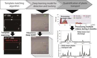
Reliable and continuous plastic monitoring in rivers is essential for quantifying plastic flux and guiding mitigation efforts. One effective strategy for observing floating plastic transport is image-based monitoring using deep learning models. We developed river surface image monitoring software (RiSIM) to quantify floating macroplastic transport through three core processes: (1) a template matching algorithm, which identifies matching areas in a frame that resemble a template given in the previous frame; (2) deep learning models for plastic detection, classification, and object tracking; and (3) the evaluation of plastic transport rate in terms of both quantity and mass. The RiSIM-derived plastic transport rates were validated through a mark-release-recapture experiment and in-situ visual observation under both non-flood and flood conditions. The temporal variability and composition of the plastic transport rate in terms of quantity and mass were in good agreement with the ground truth data (r = 0.91 and 0.80, respectively). And also, it remained valuable for capturing the temporal variability in plastic transport rate (r = 0.87) via the comparison with in-situ visual observation, indicating that the RiSIM is valuable for assessing the increase in plastic transport rate due to a flood event. In fact, we found a significant relationship (r2 = 0.36 for quantity; r2 = 0.27 for mass) between daily-mean plastic transport rates and river discharge during flood events over four months. Accordingly, the RiSIM, as a near-field remote sensing technology, is a powerful tool for quantifying plastic transport and managing mis-managed plastic waste in river environments.

河流表面图像监测软件,用于量化漂浮的宏观塑料运输
可靠和连续的河流塑料监测对于量化塑料通量和指导减缓工作至关重要。一种有效的观察漂浮塑料运输的策略是使用深度学习模型进行基于图像的监测。我们开发了河面图像监测软件(RiSIM),通过三个核心过程来量化浮动宏观塑性迁移:(1)模板匹配算法,该算法识别与前一帧中给出的模板相似的帧中的匹配区域;(2)塑料检测、分类和目标跟踪的深度学习模型;(3)从数量和质量两方面评价塑性输运率。通过非洪水和洪水条件下的标记释放-再捕获实验和现场视觉观察,验证了risim导出的塑料传输速率。在数量和质量方面,塑性输运率的时间变异性和组成与地面真实数据很好地吻合(r = 分别为0.91和0.80)。此外,通过与现场目视观测的比较,该方法对于捕获塑料输运率的时间变化(r = 0.87)仍然有价值,这表明RiSIM对于评估洪水事件引起的塑料输运率的增加是有价值的。事实上,我们发现在四个月的洪水期间,日平均塑料输运率和河流流量之间存在显著的关系(r2 = 0.36,数量;r2 = 0.27,质量)。因此,RiSIM作为一种近场遥感技术,是量化塑料运输和管理河流环境中管理不善的塑料废物的有力工具。
本文章由计算机程序翻译,如有差异,请以英文原文为准。
求助全文
约1分钟内获得全文
求助全文
来源期刊
Water Research
环境科学-工程:环境
CiteScore
20.80
自引率
9.40%
发文量
1307
审稿时长
38 days
期刊介绍:
Water Research, along with its open access companion journal Water Research X, serves as a platform for publishing original research papers covering various aspects of the science and technology related to the anthropogenic water cycle, water quality, and its management worldwide. The audience targeted by the journal comprises biologists, chemical engineers, chemists, civil engineers, environmental engineers, limnologists, and microbiologists. The scope of the journal include:
•Treatment processes for water and wastewaters (municipal, agricultural, industrial, and on-site treatment), including resource recovery and residuals management;
•Urban hydrology including sewer systems, stormwater management, and green infrastructure;
•Drinking water treatment and distribution;
•Potable and non-potable water reuse;
•Sanitation, public health, and risk assessment;
•Anaerobic digestion, solid and hazardous waste management, including source characterization and the effects and control of leachates and gaseous emissions;
•Contaminants (chemical, microbial, anthropogenic particles such as nanoparticles or microplastics) and related water quality sensing, monitoring, fate, and assessment;
•Anthropogenic impacts on inland, tidal, coastal and urban waters, focusing on surface and ground waters, and point and non-point sources of pollution;
•Environmental restoration, linked to surface water, groundwater and groundwater remediation;
•Analysis of the interfaces between sediments and water, and between water and atmosphere, focusing specifically on anthropogenic impacts;
•Mathematical modelling, systems analysis, machine learning, and beneficial use of big data related to the anthropogenic water cycle;
•Socio-economic, policy, and regulations studies.
 求助内容:
求助内容: 应助结果提醒方式:


