Unlocking groundwater potential in the yirgacheffe catchment, main ethiopian rift region: A comprehensive analytic hierarchy process and geophysical approach
IF 3.3
Q2 MULTIDISCIPLINARY SCIENCES
引用次数: 0
Abstract
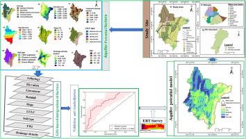
Water is an invaluable resource, and the growing demand for groundwater driven by climate change, population growth, and evolving lifestyles presents significant challenges for ensuring sustainable water development and effective management. This study combines geological, geophysical, and Analytic Hierarchy Process methods to investigate groundwater resources in the Yirgacheffe Catchment in the Main Ethiopian Rift region. These resources are vital for local economies and domestic purposes. Due to drying wells, surface water pollution, and limited hydrogeological data, water scarcity is a concern. Electrical resistivity profiling with a Wenner array and WDA-1 meter across four 236-meter profiles was processed with Res2DinV software. Using an indicator-based weighting approach with nine key factors to assess groundwater potential, the identified zones were validated through comparison with water point data and geophysical results. The geophysical analysis identified three subsurface layers: (1) a dense rhyolite ignimbrite and basalt layer with high resistivity (>2000 Ωm), (2) a weathered zone with moderate resistivity (200 – 2000 Ωm), and (3) a shallow topsoil and clay layer with low resistivity (4 – 200 Ωm). These findings show variations in rock integrity and weathering, affecting groundwater flow and construction stability. The groundwater potential map was validated with a Receiver Operating Characteristic (ROC) curve (76.6 %), revealing five groundwater potential levels: very low (12.96 %), low (28.23 %), moderate (28.91 %), high (19.82 %), and very high (10.08 %). Areas with moderate to very high potential are key for sustainable development and management. Sensitivity analysis of the Aquifer potential map revealed that lithology, elevation, and lineament are the most influential factors affecting groundwater potential. The findings of this research provide a reliable tool for decision-makers to improve groundwater resource development and management, plan for new well drilling, and adopt effective groundwater protection strategies, particularly in Yirga Cheffe town and its surroundings. Furthermore, the methodology applied in this study can be adopted in regions with similar hydrogeological settings.
解开埃塞俄比亚主要裂谷区yirgacheffe流域的地下水潜力:综合层次分析法和地球物理方法
水是一种宝贵的资源,由于气候变化、人口增长和生活方式的演变,对地下水的需求不断增长,这对确保可持续水开发和有效管理提出了重大挑战。本研究结合地质、地球物理和层次分析法对埃塞俄比亚主要裂谷地区Yirgacheffe流域的地下水资源进行了调查。这些资源对当地经济和国内用途至关重要。由于井干、地表水污染和水文地质资料有限,水资源短缺是一个令人担忧的问题。采用Res2DinV软件对四个236米剖面的Wenner阵列和WDA-1米电阻率剖面进行处理。采用基于指标的加权方法,结合9个关键因素对地下水潜力进行评价,并通过与水点数据和地球物理结果的比较,对所识别的区域进行了验证。地球物理分析确定了3个次表层:(1)高电阻率致密流纹岩和玄武岩层(>2000 Ωm),(2)中等电阻率风化带(200 ~ 2000 Ωm),(3)低电阻率浅层表土和粘土层(4 ~ 200 Ωm)。这些发现表明岩石完整性和风化的变化,影响地下水流动和建筑稳定性。利用受试者工作特征(ROC)曲线(76.6%)对地下水潜力图进行验证,揭示了5个地下水潜力水平:极低(12.96%)、低(28.23%)、中(28.91%)、高(19.82%)和极高(10.08%)。具有中等至极高潜力的地区是可持续发展和管理的关键。含水层潜力图敏感性分析表明,岩性、高程和地形是影响地下水潜力的主要因素。本研究结果为决策者提供了可靠的工具,以改善地下水资源的开发和管理,规划新井钻探,并采取有效的地下水保护策略,特别是在Yirga Cheffe镇及其周边地区。此外,本研究所采用的方法可用于具有相似水文地质背景的地区。
本文章由计算机程序翻译,如有差异,请以英文原文为准。
求助全文
约1分钟内获得全文
求助全文
来源期刊

Scientific African
Multidisciplinary-Multidisciplinary
CiteScore
5.60
自引率
3.40%
发文量
332
审稿时长
10 weeks
 求助内容:
求助内容: 应助结果提醒方式:


