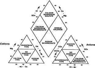
{"title":"Statistical evaluation of rainfall trends and groundwater resources in relation to agricultural production, Gondia district, Central India","authors":"Nanabhau Kudnar, Sanju Purohit, Santosh Lagad, Mahesh Meshram, Ravindra Zode","doi":"10.1007/s12517-025-12319-w","DOIUrl":null,"url":null,"abstract":"<div><p>This study’s primary goal was to determine the statistical assessment of the rainfall trend in relation to agricultural productivity and productivities in the Gondia district of Central India’s groundwater resources. Using data from eight hydrological stations, the long-term time series covering rainfall trends from 1971 to 2019 is applied using the non-parametric when working with annual rainfall data and agricultural data, and in demonstrating how the distribution of rainfall influences agriculture sectors, Mann–Kendall and Sen’s slope estimator is employed. A variety of techniques have been employed to examine the rainfall, including the use of GPS and GIS software to display the type of rainfall. Seasonal statistical study using <i>Z</i>-values revealed that average rainfall decreased (− 0.128), post-monsoon rainfall decreased (− 0.053), and pre-monsoon rainfall decreased (− 0.9), whereas monsoon rainfall increased (0.022), and winter rainfall increased (0.003), indicating a growing trend. Ground water parameters suggest that Ca + + (196.23 to 244.96) is found greater in Deori Tahsil than in other areas. Chloride levels (14.00–613.91) were highest throughout the area. The highest number of samples (68.29%) belongs to the medium salinity water group, while roughly 26.83% of samples fall into the high salinity water category. The lowest salinity groundwater percentage (4.88%) is classified as such. The Gondia district’s management and agricultural productivity will undoubtedly benefit from this research. In addition to catastrophe management and long-term planning, it can be used to ascertain the type of rainfall experienced in different districts.</p></div>","PeriodicalId":476,"journal":{"name":"Arabian Journal of Geosciences","volume":"18 10","pages":""},"PeriodicalIF":1.8270,"publicationDate":"2025-09-23","publicationTypes":"Journal Article","fieldsOfStudy":null,"isOpenAccess":false,"openAccessPdf":"","citationCount":"0","resultStr":null,"platform":"Semanticscholar","paperid":null,"PeriodicalName":"Arabian Journal of Geosciences","FirstCategoryId":"1085","ListUrlMain":"https://link.springer.com/article/10.1007/s12517-025-12319-w","RegionNum":0,"RegionCategory":null,"ArticlePicture":[],"TitleCN":null,"AbstractTextCN":null,"PMCID":null,"EPubDate":"","PubModel":"","JCR":"Q2","JCRName":"Earth and Planetary Sciences","Score":null,"Total":0}
引用次数: 0
Abstract
This study’s primary goal was to determine the statistical assessment of the rainfall trend in relation to agricultural productivity and productivities in the Gondia district of Central India’s groundwater resources. Using data from eight hydrological stations, the long-term time series covering rainfall trends from 1971 to 2019 is applied using the non-parametric when working with annual rainfall data and agricultural data, and in demonstrating how the distribution of rainfall influences agriculture sectors, Mann–Kendall and Sen’s slope estimator is employed. A variety of techniques have been employed to examine the rainfall, including the use of GPS and GIS software to display the type of rainfall. Seasonal statistical study using Z-values revealed that average rainfall decreased (− 0.128), post-monsoon rainfall decreased (− 0.053), and pre-monsoon rainfall decreased (− 0.9), whereas monsoon rainfall increased (0.022), and winter rainfall increased (0.003), indicating a growing trend. Ground water parameters suggest that Ca + + (196.23 to 244.96) is found greater in Deori Tahsil than in other areas. Chloride levels (14.00–613.91) were highest throughout the area. The highest number of samples (68.29%) belongs to the medium salinity water group, while roughly 26.83% of samples fall into the high salinity water category. The lowest salinity groundwater percentage (4.88%) is classified as such. The Gondia district’s management and agricultural productivity will undoubtedly benefit from this research. In addition to catastrophe management and long-term planning, it can be used to ascertain the type of rainfall experienced in different districts.
期刊介绍:
The Arabian Journal of Geosciences is the official journal of the Saudi Society for Geosciences and publishes peer-reviewed original and review articles on the entire range of Earth Science themes, focused on, but not limited to, those that have regional significance to the Middle East and the Euro-Mediterranean Zone.
Key topics therefore include; geology, hydrogeology, earth system science, petroleum sciences, geophysics, seismology and crustal structures, tectonics, sedimentology, palaeontology, metamorphic and igneous petrology, natural hazards, environmental sciences and sustainable development, geoarchaeology, geomorphology, paleo-environment studies, oceanography, atmospheric sciences, GIS and remote sensing, geodesy, mineralogy, volcanology, geochemistry and metallogenesis.


 求助内容:
求助内容: 应助结果提醒方式:


