Exploring the potential of radar vegetation indices for soil parameters retrieval: a case study of remote sensing soil salinity mapping
IF 5.7
1区 农林科学
Q1 GEOSCIENCES, MULTIDISCIPLINARY
引用次数: 0
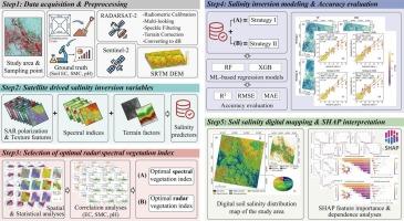
Abstract
Accurate and timely monitoring of soil parameters is fundamental for sustainable land management and ecosystem preservation. In recent years, advances in synthetic aperture radar (SAR) technology have opened new avenues for comprehensive, all-weather soil property characterization, enabling improved detection of key attributes such as soil moisture and salt content under diverse conditions. This study investigates the potential of radar vegetation indices (RVIs) derived from fully polarimetric RADARSAT-2 C-band SAR data to enhance soil parameter retrieval, focusing on soil salinity as a case study, along with supplemental analysis of soil moisture content (SMC) and pH, in the Yutian Oasis, northwestern China. Five RVIs (RVIKim, RVIFreeman, RVIVanZyl, Generalized RVI (GRVI), and Compact Polarimetric RVI (CpRVI)) were computed and contrasted with four multispectral optical indices (NDVI, SAVI, BSI, and SIT). Using in-situ soil samples, we developed Random Forest (RF) and eXtreme Gradient Boosting (XGB) models implementing two strategies: Strategy I incorporating optical NDVI, and Strategy II utilizing SAR-based CpRVI, both complemented by microwave, optical, topographic and texture covariates. Repeated 5-fold cross-validation demonstrated that Strategy II outperformed Strategy I (R2 = 0.811 and MAE = 2.873 vs. R2 = 0.797 and MAE = 2.942 dS/m). Model interpretability analysis (SHAP analysis) revealed CpRVI as the fourth most influential feature (13.9 % contribution), surpassing NDVI (6.0 %). Moreover, GRVI and CpRVI exhibited moderate negative correlations with soil pH (r ≈ –0.34, P < 0.01), while RVIs showed generally weak correlations with SMC. The findings affirm that RVIs provide complementary and improved information beyond traditional optical indices, enabling cost-effective, operational soil parameter monitoring in arid, data-limited landscapes. This study establishes a referenceable framework integrating fully polarimetric SAR-derived vegetation structure metrics with interpretable machine learning to enhance precision salinity mapping and promote sustainable land use.
探讨雷达植被指数在土壤参数检索中的潜力:以遥感土壤盐度制图为例
准确、及时地监测土壤参数是可持续土地管理和生态系统保护的基础。近年来,合成孔径雷达(SAR)技术的进步为全面、全天候的土壤特性表征开辟了新的途径,可以在不同条件下更好地检测土壤水分和盐分含量等关键属性。研究了基于RADARSAT-2全极化c波段SAR数据的雷达植被指数(RVIs)在土壤参数检索中的应用潜力,并以土壤盐度为例,对中国西北玉田绿洲土壤水分含量(SMC)和pH值进行了补充分析。计算了5种RVIs (RVIKim、RVIFreeman、RVIVanZyl、Generalized RVI (GRVI)和Compact Polarimetric RVI (CpRVI)),并与4种多光谱光学指数(NDVI、SAVI、BSI和SIT)进行了对比。利用原位土壤样本,我们开发了随机森林(RF)和极端梯度增强(XGB)模型,实现了两种策略:策略一采用光学NDVI,策略二采用基于sar的CpRVI,两者都辅以微波、光学、地形和纹理协变量。重复5倍交叉验证表明,策略II优于策略I (R2 = 0.811, MAE = 2.873 vs. R2 = 0.797, MAE = 2.942 dS/m)。模型可解释性分析(SHAP)显示,CpRVI是第四大影响特征(贡献13.9%),超过NDVI(6.0%)。GRVI和CpRVI与土壤pH呈中等负相关(r≈-0.34,P < 0.01),而RVIs与SMC呈弱相关。研究结果证实,RVIs提供了传统光学指数之外的补充和改进的信息,能够在干旱、数据有限的景观中实现成本效益高、可操作的土壤参数监测。本研究建立了一个可参考的框架,将完全极化sar衍生的植被结构指标与可解释的机器学习相结合,以提高盐度测绘的精度,促进土地的可持续利用。
本文章由计算机程序翻译,如有差异,请以英文原文为准。
求助全文
约1分钟内获得全文
求助全文
来源期刊

Catena
环境科学-地球科学综合
CiteScore
10.50
自引率
9.70%
发文量
816
审稿时长
54 days
期刊介绍:
Catena publishes papers describing original field and laboratory investigations and reviews on geoecology and landscape evolution with emphasis on interdisciplinary aspects of soil science, hydrology and geomorphology. It aims to disseminate new knowledge and foster better understanding of the physical environment, of evolutionary sequences that have resulted in past and current landscapes, and of the natural processes that are likely to determine the fate of our terrestrial environment.
Papers within any one of the above topics are welcome provided they are of sufficiently wide interest and relevance.
 求助内容:
求助内容: 应助结果提醒方式:


