Multi-source remote sensing-based soil moisture retrieval at different depths in the Naqu Region, Tibetan Plateau: a comparative analysis of machine learning models with modified water cloud model preprocessing
{"title":"Multi-source remote sensing-based soil moisture retrieval at different depths in the Naqu Region, Tibetan Plateau: a comparative analysis of machine learning models with modified water cloud model preprocessing","authors":"Zhong Tong, Jinhui Hu, Ji Xiong, Chao Li, Aoxuan Pang, Changtao Deng, Qiuwen Zhang","doi":"10.1007/s12665-025-12514-8","DOIUrl":null,"url":null,"abstract":"<div><p>Soil moisture is a critical environmental variable, but its retrieval in high-altitude regions is challenging due to Limited ground-truth data, frequent freeze-thaw cycles that alter soil dielectric properties, and complex surface-vegetation interactions unique to alpine ecosystems. This study addresses these challenges by developing an integrated framework for soil moisture retrieval at 10, 20, and 40 cm depths in the Naqu region, Tibetan Plateau. To isolate the soil backscatter signal from vegetation interference, we first apply a modified Water Cloud Model that incorporates vegetation structure by accounting for fractional vegetation cover and height. Subsequently, we compare the performance of five machine learning models (polynomial regression, 1D CNN, MLP, KAN, and an attention-based model) using the processed backscatter data and optical vegetation indices. The t raining dataset was augmented to improve model generalization. The modified WCM proved highly effective, improving the correlation between backscatter and soil moisture by up to 51% (at 20 cm depth). The comparative analysis revealed that model performance is depth-dependent: the attention-based model was optimal for surface moisture at 10 cm (R² = 0.713), MLP excelled at 20 cm (R² = 0.786), and KAN was superior at 40 cm (R² = 0.780). These findings highlight the importance of physically-based vegetation correction and provide a guide for selecting depth-specific models for soil moisture retrieval in complex high-altitude environments, offering valuable insights for hydrological modeling and ecological monitoring.</p></div>","PeriodicalId":542,"journal":{"name":"Environmental Earth Sciences","volume":"84 19","pages":""},"PeriodicalIF":2.8000,"publicationDate":"2025-09-22","publicationTypes":"Journal Article","fieldsOfStudy":null,"isOpenAccess":false,"openAccessPdf":"","citationCount":"0","resultStr":null,"platform":"Semanticscholar","paperid":null,"PeriodicalName":"Environmental Earth Sciences","FirstCategoryId":"93","ListUrlMain":"https://link.springer.com/article/10.1007/s12665-025-12514-8","RegionNum":4,"RegionCategory":"环境科学与生态学","ArticlePicture":[],"TitleCN":null,"AbstractTextCN":null,"PMCID":null,"EPubDate":"","PubModel":"","JCR":"Q3","JCRName":"ENVIRONMENTAL SCIENCES","Score":null,"Total":0}
引用次数: 0
Abstract
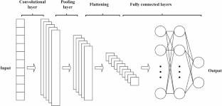
Soil moisture is a critical environmental variable, but its retrieval in high-altitude regions is challenging due to Limited ground-truth data, frequent freeze-thaw cycles that alter soil dielectric properties, and complex surface-vegetation interactions unique to alpine ecosystems. This study addresses these challenges by developing an integrated framework for soil moisture retrieval at 10, 20, and 40 cm depths in the Naqu region, Tibetan Plateau. To isolate the soil backscatter signal from vegetation interference, we first apply a modified Water Cloud Model that incorporates vegetation structure by accounting for fractional vegetation cover and height. Subsequently, we compare the performance of five machine learning models (polynomial regression, 1D CNN, MLP, KAN, and an attention-based model) using the processed backscatter data and optical vegetation indices. The t raining dataset was augmented to improve model generalization. The modified WCM proved highly effective, improving the correlation between backscatter and soil moisture by up to 51% (at 20 cm depth). The comparative analysis revealed that model performance is depth-dependent: the attention-based model was optimal for surface moisture at 10 cm (R² = 0.713), MLP excelled at 20 cm (R² = 0.786), and KAN was superior at 40 cm (R² = 0.780). These findings highlight the importance of physically-based vegetation correction and provide a guide for selecting depth-specific models for soil moisture retrieval in complex high-altitude environments, offering valuable insights for hydrological modeling and ecological monitoring.
土壤湿度是一个关键的环境变量,但在高海拔地区,由于地面真实数据有限,频繁的冻融循环会改变土壤介电特性,以及高山生态系统特有的复杂的地表-植被相互作用,土壤湿度的恢复具有挑战性。为了从植被干扰中分离土壤后向散射信号,我们首先应用了一个改进的水云模型,该模型通过考虑植被覆盖度和植被高度来考虑植被结构。随后,我们利用处理后的后向散射数据和光学植被指数,比较了五种机器学习模型(多项式回归、1D CNN、MLP、KAN和基于注意力的模型)的性能。增强训练数据集以提高模型泛化。改进后的WCM被证明是非常有效的,将反向散射与土壤湿度之间的相关性提高了51%(在20 cm深度)。对比分析表明,模型的性能与深度相关:基于注意力的模型在10 cm (R²= 0.713)处表现最佳,MLP在20 cm (R²= 0.786)处表现最佳,KAN在40 cm (R²= 0.780)处表现最佳。这些发现突出了基于物理的植被校正的重要性,并为在复杂的高海拔环境中选择特定深度的土壤水分反演模型提供了指导,为水文建模和生态监测提供了有价值的见解。
期刊介绍:
Environmental Earth Sciences is an international multidisciplinary journal concerned with all aspects of interaction between humans, natural resources, ecosystems, special climates or unique geographic zones, and the earth:
Water and soil contamination caused by waste management and disposal practices
Environmental problems associated with transportation by land, air, or water
Geological processes that may impact biosystems or humans
Man-made or naturally occurring geological or hydrological hazards
Environmental problems associated with the recovery of materials from the earth
Environmental problems caused by extraction of minerals, coal, and ores, as well as oil and gas, water and alternative energy sources
Environmental impacts of exploration and recultivation – Environmental impacts of hazardous materials
Management of environmental data and information in data banks and information systems
Dissemination of knowledge on techniques, methods, approaches and experiences to improve and remediate the environment
In pursuit of these topics, the geoscientific disciplines are invited to contribute their knowledge and experience. Major disciplines include: hydrogeology, hydrochemistry, geochemistry, geophysics, engineering geology, remediation science, natural resources management, environmental climatology and biota, environmental geography, soil science and geomicrobiology.

 求助内容:
求助内容: 应助结果提醒方式:


