Territorial mapping of soil type and land cover influence on ecosystem services
IF 3.3
2区 农林科学
Q2 SOIL SCIENCE
引用次数: 0
Abstract
The delivery of soil-based ecosystem services (ES) is of increasing importance for spatial planners. Soils are complex and heterogeneous systems, therefore synthesizing pedological expertise into decision support maps presents ongoing challenges. Our approach considers the properties of the entire pedon to assess the contribution of different soil types and land covers to ES delivery at the territorial scale.
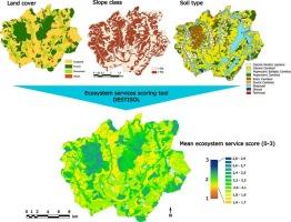
This study adapts the Destisol decision support tool, initially developed for urban soils and therefore adapted to a high variety of pedons influenced by human activities, to a rural setting containing croplands, grasslands and forests. 86 soil profiles from the study territory are grouped into eight dominant soil types. Nine ES are evaluated based on the horizon-specific physico-chemical properties of each soil type, and mapped following a territorial 1/50,000 pedological map.
The study territory has a high potential for ES provision with a mean score of 2 +/− 0.2 (min: 1.7, max: 2.7) on a scale of 0 to 3. Soil type is shown to have a significant impact on ES supply under the same land cover. Eutric Cambisols rank highly for provisioning and regulating services, Gleysols rank poorly for water quality but highly for global climate mitigation, and shallow rocky soils rank poorly for most services except water infiltration. Mapping results and soil-type specific ES scores can be used as spatial planning tools to quantify the impact of a given scenario of land cover change on ES scores, and thereby contribute to efforts towards no net loss of soil functionality.
土壤类型和土地覆盖对生态系统服务的影响
土壤生态系统服务(ES)的提供对空间规划者来说越来越重要。土壤是复杂的异质系统,因此将土壤学专业知识综合到决策支持地图中提出了持续的挑战。我们的方法考虑了整个土地的性质,以评估不同土壤类型和土地覆盖对领土尺度上ES传递的贡献。本研究将Destisol决策支持工具(最初是为城市土壤开发的,因此适用于受人类活动影响的多种土壤)调整为包含农田、草原和森林的农村环境。研究区86条土壤剖面被划分为8种主要土壤类型。根据每种土壤类型的水平特异性物理化学性质对9个ES进行了评估,并按照1/50,000的领土土壤学地图进行了绘制。在0到3分的范围内,研究区域提供ES的潜力很大,平均得分为2 +/ - 0.2(最低得分为1.7,最高得分为2.7)。在相同土地覆盖下,土壤类型对ES供应有显著影响。营养盐Cambisols在提供和调节服务方面排名靠前,Gleysols在水质方面排名靠后,但在全球气候减缓方面排名靠前,浅岩质土壤在除水渗透外的大多数服务方面排名靠后。制图结果和特定土壤类型的ES得分可作为空间规划工具,量化给定土地覆盖变化情景对ES得分的影响,从而有助于实现土壤功能无净损失的目标。
本文章由计算机程序翻译,如有差异,请以英文原文为准。
求助全文
约1分钟内获得全文
求助全文
来源期刊

Geoderma Regional
Agricultural and Biological Sciences-Soil Science
CiteScore
6.10
自引率
7.30%
发文量
122
审稿时长
76 days
期刊介绍:
Global issues require studies and solutions on national and regional levels. Geoderma Regional focuses on studies that increase understanding and advance our scientific knowledge of soils in all regions of the world. The journal embraces every aspect of soil science and welcomes reviews of regional progress.
 求助内容:
求助内容: 应助结果提醒方式:


