{"title":"GIS-based optimization of photovoltaic panel orientation in Benin using genetic algorithms and K-means clustering","authors":"Nounangnonhou Cossi Télesphore , Aza-Gnandji Maurel Richy , Zantou Fiacre , Kple Melhyas , Didavi Kossoko Babatoundé Audace , Aguemon Dourodjayé Pierre , Amoussou Isaac , Semassou Guy Clarence , Fifatin François-Xavier","doi":"10.1016/j.solcom.2025.100142","DOIUrl":null,"url":null,"abstract":"<div><div>Accurately determining the orientation of fixed-tilt photovoltaic (PV) panels is critical for maximizing annual energy output, yet most installations in Benin continue to rely on empirical or generalized guidelines. This study develops a high-resolution (0.05° × 0.05°) geospatial database of optimal tilt (β*) and azimuth (α*) angles across the country by coupling the Perrin-de-Brichambaut clear-sky model with a Genetic Algorithm, that uses 2023 NASA-POWER meteorological inputs. Results show that β* increases from approximately 6° along the southern coast to around 13° in the far north, while α* evolves from a slight westerly orientation to a moderate easterly preference above 8°N latitude. To facilitate practical implementation, K-means clustering was applied separately to both angle datasets, with the number of clusters determined via the Kneedle algorithm. The resulting 3 tilt and 3 azimuth clusters combine into 8 implementation-ready mounting configurations that retain >95 % of the energy yield provided by fully site-specific optimization, while substantially simplifying system design. The accompanying orientation atlas, GIS layers, and open-source Python code offer a scalable and evidence-based planning tool for PV deployment in Benin, supporting policymakers, engineers, and developers in accelerating the energy transition.</div></div>","PeriodicalId":101173,"journal":{"name":"Solar Compass","volume":"16 ","pages":"Article 100142"},"PeriodicalIF":0.0000,"publicationDate":"2025-09-01","publicationTypes":"Journal Article","fieldsOfStudy":null,"isOpenAccess":false,"openAccessPdf":"","citationCount":"0","resultStr":null,"platform":"Semanticscholar","paperid":null,"PeriodicalName":"Solar Compass","FirstCategoryId":"1085","ListUrlMain":"https://www.sciencedirect.com/science/article/pii/S2772940025000372","RegionNum":0,"RegionCategory":null,"ArticlePicture":[],"TitleCN":null,"AbstractTextCN":null,"PMCID":null,"EPubDate":"","PubModel":"","JCR":"","JCRName":"","Score":null,"Total":0}
引用次数: 0
Abstract
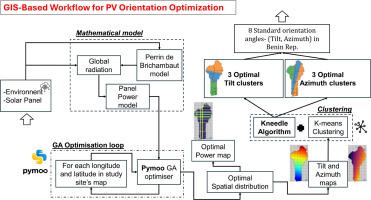
Accurately determining the orientation of fixed-tilt photovoltaic (PV) panels is critical for maximizing annual energy output, yet most installations in Benin continue to rely on empirical or generalized guidelines. This study develops a high-resolution (0.05° × 0.05°) geospatial database of optimal tilt (β*) and azimuth (α*) angles across the country by coupling the Perrin-de-Brichambaut clear-sky model with a Genetic Algorithm, that uses 2023 NASA-POWER meteorological inputs. Results show that β* increases from approximately 6° along the southern coast to around 13° in the far north, while α* evolves from a slight westerly orientation to a moderate easterly preference above 8°N latitude. To facilitate practical implementation, K-means clustering was applied separately to both angle datasets, with the number of clusters determined via the Kneedle algorithm. The resulting 3 tilt and 3 azimuth clusters combine into 8 implementation-ready mounting configurations that retain >95 % of the energy yield provided by fully site-specific optimization, while substantially simplifying system design. The accompanying orientation atlas, GIS layers, and open-source Python code offer a scalable and evidence-based planning tool for PV deployment in Benin, supporting policymakers, engineers, and developers in accelerating the energy transition.

 求助内容:
求助内容: 应助结果提醒方式:


