{"title":"Evaluation of geo-factor weights with ESWA and AHP techniques for GIS-based seismic hazard modeling of Thiruvananthapuram city","authors":"Suresh Ellappa Subramani, Madhu Mohan Velapgy","doi":"10.1007/s12517-025-12321-2","DOIUrl":null,"url":null,"abstract":"<div><p>This study focuses on the assessment of geo-factor weights for the development of Geographic Information System (GIS)-based seismic hazard map, using a simplified Empirical Susceptibility Weights Approach (ESWA) and analytic hierarchy process (AHP) for Thiruvananthapuram city, a rapidly growing urban area in the southern Peninsular India (PI). The influencing factors related to the ground characteristics, contributing to the seismicity of the region considered as inputs for the development of the model/map, include the peak ground acceleration (PGA), geology, lineaments/faults, geomorphology, elevation, slope, soil distribution, and building density pertaining to the study area. The thematic factors and the classes within each factor are assigned respective weights and ranks, using a hybrid evaluation of ESWA and AHP methods for an unbiased estimation of susceptibility levels of attributes. Based on the thematic layer weights and rank values, Susceptibility Index (SI) was finally calculated by applying a weighted linear combination (WLC) model in GIS. These continuous numerical index values have been divided into different classes. The classification result implies that it provides distinctive distribution of risk levels varying from very low to high ranges in the seismic hazard mapping of Thiruvananthapuram city, and the PGA corresponding to the high-risk zone in the region had been estimated.\n</p></div>","PeriodicalId":476,"journal":{"name":"Arabian Journal of Geosciences","volume":"18 10","pages":""},"PeriodicalIF":1.8270,"publicationDate":"2025-09-12","publicationTypes":"Journal Article","fieldsOfStudy":null,"isOpenAccess":false,"openAccessPdf":"","citationCount":"0","resultStr":null,"platform":"Semanticscholar","paperid":null,"PeriodicalName":"Arabian Journal of Geosciences","FirstCategoryId":"1085","ListUrlMain":"https://link.springer.com/article/10.1007/s12517-025-12321-2","RegionNum":0,"RegionCategory":null,"ArticlePicture":[],"TitleCN":null,"AbstractTextCN":null,"PMCID":null,"EPubDate":"","PubModel":"","JCR":"Q2","JCRName":"Earth and Planetary Sciences","Score":null,"Total":0}
引用次数: 0
Abstract
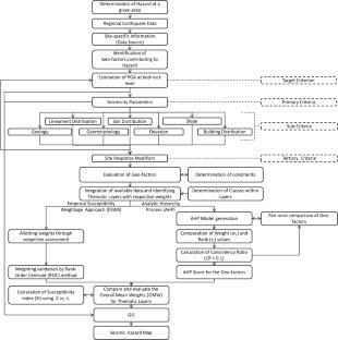
This study focuses on the assessment of geo-factor weights for the development of Geographic Information System (GIS)-based seismic hazard map, using a simplified Empirical Susceptibility Weights Approach (ESWA) and analytic hierarchy process (AHP) for Thiruvananthapuram city, a rapidly growing urban area in the southern Peninsular India (PI). The influencing factors related to the ground characteristics, contributing to the seismicity of the region considered as inputs for the development of the model/map, include the peak ground acceleration (PGA), geology, lineaments/faults, geomorphology, elevation, slope, soil distribution, and building density pertaining to the study area. The thematic factors and the classes within each factor are assigned respective weights and ranks, using a hybrid evaluation of ESWA and AHP methods for an unbiased estimation of susceptibility levels of attributes. Based on the thematic layer weights and rank values, Susceptibility Index (SI) was finally calculated by applying a weighted linear combination (WLC) model in GIS. These continuous numerical index values have been divided into different classes. The classification result implies that it provides distinctive distribution of risk levels varying from very low to high ranges in the seismic hazard mapping of Thiruvananthapuram city, and the PGA corresponding to the high-risk zone in the region had been estimated.
期刊介绍:
The Arabian Journal of Geosciences is the official journal of the Saudi Society for Geosciences and publishes peer-reviewed original and review articles on the entire range of Earth Science themes, focused on, but not limited to, those that have regional significance to the Middle East and the Euro-Mediterranean Zone.
Key topics therefore include; geology, hydrogeology, earth system science, petroleum sciences, geophysics, seismology and crustal structures, tectonics, sedimentology, palaeontology, metamorphic and igneous petrology, natural hazards, environmental sciences and sustainable development, geoarchaeology, geomorphology, paleo-environment studies, oceanography, atmospheric sciences, GIS and remote sensing, geodesy, mineralogy, volcanology, geochemistry and metallogenesis.


 求助内容:
求助内容: 应助结果提醒方式:


