Seismogenic Activation of a Fault in the Late Neopleistocene by Deformations in the Topography, Sediments, and Basement Rocks in the Southeast of Fennoscandia
S. V. Shvarev, I. V. Bondar, A. O. Koroleva, A. O. Komarov
{"title":"Seismogenic Activation of a Fault in the Late Neopleistocene by Deformations in the Topography, Sediments, and Basement Rocks in the Southeast of Fennoscandia","authors":"S. V. Shvarev, I. V. Bondar, A. O. Koroleva, A. O. Komarov","doi":"10.3103/S0747923925700318","DOIUrl":null,"url":null,"abstract":"<p>Comprehensive studies of seismogenic deformations in the topography, sediments, and rocks of the crystalline basement using structural-geomorphological, geophysical, and tectonophysical methods have been carried out. Based on the materials of deciphering digital elevation models, a hierarchical block-fault structure has been established, which has been partially inherited and activated in recent times and corresponds to the topographic forms and linear accumulative formations (eskers and plumes) “inscribed” in the tectonic framework. Ruptures of different kinematic types, folds, and forms of liquefaction in gravel-sand deposits have been discovered and documented within one of the massifs. The separations of reverse faults reach 1–2.2 m; those of normal faults are 1.5–4.5 m. Eight horizons with deformations have been identified, the thickness of the largest of which is ≈4 m, and the age range according to OSL dating is from 53 ± 3 cal. kyr to 41 ± 3 cal. kyr. This horizon corresponds to the parameters of the paleoearthquake of IX+ points. Other deformation horizons have a thickness from 0.1 to 0.4 m and are formed by weaker events, one of which occurred before the maximum glaciation, while six occurred later, in the Late Glacial period. Ruptures can be traced in the sediment sequences with depths of up to the first meters according to geolocation data. In the crystalline rocks in the zone of the esker and the faults controlling it, crushing zones and sliding mirrors were found, indicating a consistent activation of faults. The strike-slip and reverse character of the ruptures with a northwesterly strike line and east–northeast and southwest dip azimuths corresponding to ruptures in loose sediments and the general latest structural plan has been established.</p>","PeriodicalId":45174,"journal":{"name":"Seismic Instruments","volume":"61 1","pages":"58 - 90"},"PeriodicalIF":0.3000,"publicationDate":"2025-08-08","publicationTypes":"Journal Article","fieldsOfStudy":null,"isOpenAccess":false,"openAccessPdf":"","citationCount":"0","resultStr":null,"platform":"Semanticscholar","paperid":null,"PeriodicalName":"Seismic Instruments","FirstCategoryId":"1085","ListUrlMain":"https://link.springer.com/article/10.3103/S0747923925700318","RegionNum":0,"RegionCategory":null,"ArticlePicture":[],"TitleCN":null,"AbstractTextCN":null,"PMCID":null,"EPubDate":"","PubModel":"","JCR":"Q4","JCRName":"GEOCHEMISTRY & GEOPHYSICS","Score":null,"Total":0}
引用次数: 0
Abstract
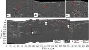
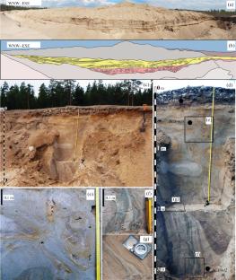
Comprehensive studies of seismogenic deformations in the topography, sediments, and rocks of the crystalline basement using structural-geomorphological, geophysical, and tectonophysical methods have been carried out. Based on the materials of deciphering digital elevation models, a hierarchical block-fault structure has been established, which has been partially inherited and activated in recent times and corresponds to the topographic forms and linear accumulative formations (eskers and plumes) “inscribed” in the tectonic framework. Ruptures of different kinematic types, folds, and forms of liquefaction in gravel-sand deposits have been discovered and documented within one of the massifs. The separations of reverse faults reach 1–2.2 m; those of normal faults are 1.5–4.5 m. Eight horizons with deformations have been identified, the thickness of the largest of which is ≈4 m, and the age range according to OSL dating is from 53 ± 3 cal. kyr to 41 ± 3 cal. kyr. This horizon corresponds to the parameters of the paleoearthquake of IX+ points. Other deformation horizons have a thickness from 0.1 to 0.4 m and are formed by weaker events, one of which occurred before the maximum glaciation, while six occurred later, in the Late Glacial period. Ruptures can be traced in the sediment sequences with depths of up to the first meters according to geolocation data. In the crystalline rocks in the zone of the esker and the faults controlling it, crushing zones and sliding mirrors were found, indicating a consistent activation of faults. The strike-slip and reverse character of the ruptures with a northwesterly strike line and east–northeast and southwest dip azimuths corresponding to ruptures in loose sediments and the general latest structural plan has been established.
期刊介绍:
Seismic Instruments is a journal devoted to the description of geophysical instruments used in seismic research. In addition to covering the actual instruments for registering seismic waves, substantial room is devoted to solving instrumental-methodological problems of geophysical monitoring, applying various methods that are used to search for earthquake precursors, to studying earthquake nucleation processes and to monitoring natural and technogenous processes. The description of the construction, working elements, and technical characteristics of the instruments, as well as some results of implementation of the instruments and interpretation of the results are given. Attention is paid to seismic monitoring data and earthquake catalog quality Analysis.
 求助内容:
求助内容: 应助结果提醒方式:


