Ecological variation and early village organization in formative cusco, peru: A GIS-based approach
IF 1.5
2区 历史学
0 ARCHAEOLOGY
引用次数: 0
Abstract
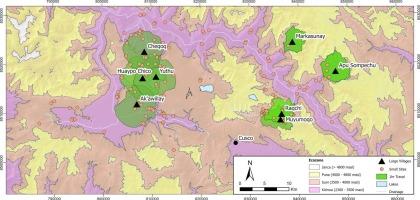
We utilize GIS to analyze regional settlement survey data to understand the transition to agropastoral village life in the Cusco region of highland Peru during the Late Formative Period (600 BCE − 200 CE) and long-term success of settlements on the landscape. We model cost catchment areas within 1, 2, and 4 h of travel from each of the eight largest Formative villages in the study region. We take into consideration the different ecozones each of these communities would have access to as well as the amount of potentially arable farmland within each catchment. To examine relationships between village locations and accessibility to other Formative settlements, we quantify the sites within each travel area and examine portions of the landscape where areas overlap. We also model viewsheds and cumulative visibility for each settlement to consider how visibility of the surrounding landscape and neighboring communities might have informed the selection and growth of certain sites. These data highlight 4 clusters or zones of interaction within the study region where established villages differ in terms of their accessibility, proximity, and overlap to smaller villages: 1) the Xaquixaguana Basin around Lake Huaypo, 2) the Chit’apampa Basin, 3) the transverse valleys to the north of the Sacred Valley, and 4) the Sacred Valley. Although we cannot presume the contemporaneity and continuous occupation of all settlements throughout the Late Formative Period, these data provide testable archaeological hypotheses as to how early villagers navigated different local landscapes as they developed agropastoral subsistence strategies, and how their social interactions shaped the coalescence of permanent villages. Some of these settlements grew to be significantly larger and continued to be occupied in subsequent periods, suggesting that the proximity and placement of sites on these landscapes influenced occupational trajectories and regional sociopolitics. Ultimately, we conclude that large sites settled in areas with access to arable farmland to cultivate maize and that had reduced risk of frost continued to be occupied past the Formative. Our results highlight the utility of synchronic analyses of survey data to generate testable hypotheses about long-term settlement continuity in ecologically diverse regions.
秘鲁库斯科形成期的生态变异与早期村落组织:基于gis的方法
我们利用GIS分析区域聚集体调查数据,以了解秘鲁高原库斯科地区在形成期晚期(公元前600年至公元前200年)向农牧乡村生活的过渡,以及聚集体在景观上的长期成功。我们对研究区域内8个最大的形成性村庄的1小时、2小时和4小时内的集水区进行了建模。我们考虑了每个社区可以进入的不同生态区,以及每个集水区内潜在可耕地的数量。为了研究村庄位置与其他形成性聚落的可达性之间的关系,我们量化了每个旅游区域内的地点,并研究了区域重叠的景观部分。我们还对每个聚落的视野和累积可见性进行建模,以考虑周围景观和邻近社区的可见性如何影响某些地点的选择和发展。这些数据突出了研究区域内4个相互作用的集群或区域,其中已建立的村庄在可达性、邻近性和与较小村庄的重叠方面存在差异:1)花坡湖周围的Xaquixaguana盆地,2)Chit 'apampa盆地,3)圣谷北部的横向山谷,以及4)圣谷。尽管我们不能假设所有定居点在整个后期形成时期的同代人和连续占领,但这些数据提供了可测试的考古假设,说明早期村民如何在发展农牧生存策略的过程中导航不同的当地景观,以及他们的社会互动如何塑造了永久村庄的融合。其中一些定居点变得更大,并在随后的时期继续被占用,这表明这些景观上遗址的邻近和位置影响了职业轨迹和区域社会政治。最终,我们得出结论,在有可耕种的农田种植玉米的地区定居的大型地点在形成期之后继续被占用,并且霜冻风险降低。我们的研究结果强调了对调查数据的同步分析的效用,以产生关于生态多样性地区长期定居连续性的可测试假设。
本文章由计算机程序翻译,如有差异,请以英文原文为准。
求助全文
约1分钟内获得全文
求助全文
来源期刊
Journal of Archaeological Science-Reports
ARCHAEOLOGY-
CiteScore
3.10
自引率
12.50%
发文量
405
期刊介绍:
Journal of Archaeological Science: Reports is aimed at archaeologists and scientists engaged with the application of scientific techniques and methodologies to all areas of archaeology. The journal focuses on the results of the application of scientific methods to archaeological problems and debates. It will provide a forum for reviews and scientific debate of issues in scientific archaeology and their impact in the wider subject. Journal of Archaeological Science: Reports will publish papers of excellent archaeological science, with regional or wider interest. This will include case studies, reviews and short papers where an established scientific technique sheds light on archaeological questions and debates.
 求助内容:
求助内容: 应助结果提醒方式:


