Quantifying permanent gully erosion: Spatial patterns, volume estimation, and morphological dynamics in the loess hilly and gully region of China
IF 5.7
1区 农林科学
Q1 GEOSCIENCES, MULTIDISCIPLINARY
引用次数: 0
Abstract
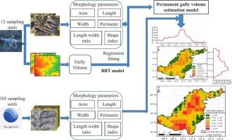
Permanent gully erosion is a significant contribute to land degradation, adversely affecting agricultural productivity and ecological integrity, which in turn poses a threat to regional environmental security and sustainable development. Accurate estimation of permanent gully erosion volumes and delineation of permanent gully morphological characteristics and spatial distribution patterns are crucial for developing targeted mitigation measures. This study integrates low-altitude unmanned aerial vehicle (UAV) photogrammetry and remote sensing imagery to construct a permanent gully volume model () in the loess hilly-gully region of China. The application of the Boosted Regression Trees model for threshold segmentation based on length–width ratios further enhanced the model’s accuracy (R2 = 0.9471, NSE = 0.9377). This study extracted the morphological parameters of 2,266 permanent gullies and found that their perimeters, areas, volumes, lengths, and widths ranged from 53.75 to 4,407.27 m, 12.94–5.49 × 10⁴ m2, 96.39–1.08 × 10⁶ m3, 16.73–629.37 m, and 3.72–130.24 m, respectively. Significant spatial variability in the distribution of permanent gullies was observed, with the most severe erosion concentrated in the central and northern areas, where gully densities exceeded 3 km km−2 (accounting for 24.82 % of the study area) and volumes surpassed 5 × 10⁵ m3 (accounting for 37.77 % of the study area). These areas are characterized by significant topographic relief, high rainfall intensity, and low vegetation cover. This research establishes a comprehensive framework for assessing permanent gully erosion volumes in the loess hilly-gully region and offers essential scientific evidence for the development of effective soil conservation and land management strategies in this vulnerable area. The findings are crucial for advancing sustainable development and enhancing ecological security in regions prone to severe gully erosion.
中国黄土丘陵沟壑区永久沟壑区侵蚀量化:空间格局、体积估算和形态动态
永久性沟壑侵蚀是土地退化的重要原因,对农业生产力和生态完整性产生不利影响,进而对区域环境安全和可持续发展构成威胁。准确估算永久沟壑侵蚀量,圈定永久沟壑形态特征和空间分布格局,对于制定有针对性的缓解措施至关重要。本研究将低空无人机(UAV)摄影测量与遥感影像相结合,构建了中国黄土丘陵沟壑区永久沟壑体积模型(V=0.1215A1.4395)。应用boosting Regression Trees模型进行基于长宽比的阈值分割,进一步提高了模型的准确率(R2 = 0.9471, NSE = 0.9377)。提取了2266条永久沟渠的形态参数,发现其周长为53.75 ~ 4407.27 m,面积为12.94 ~ 5.49 × 10⁴ m2,体积为96.39 ~ 1.08 × 10⁶ m3,长度为16.73 ~ 629.37 m,宽度为3.72 ~ 130.24 m。永久沟槽分布具有显著的空间变异性,侵蚀最严重的区域集中在中部和北部,沟槽密度超过3 km km−2(占研究区面积的24.82%),体积超过5 × 10⁵ m3(占研究区面积的37.77%)。这些地区的特点是地形起伏明显,降雨强度大,植被覆盖率低。本研究建立了黄土丘陵沟壑区永久沟壑区侵蚀量评估的综合框架,为制定有效的土壤保持和土地管理策略提供了重要的科学依据。这一发现对于促进严重沟壑区的可持续发展和加强生态安全至关重要。
本文章由计算机程序翻译,如有差异,请以英文原文为准。
求助全文
约1分钟内获得全文
求助全文
来源期刊

Catena
环境科学-地球科学综合
CiteScore
10.50
自引率
9.70%
发文量
816
审稿时长
54 days
期刊介绍:
Catena publishes papers describing original field and laboratory investigations and reviews on geoecology and landscape evolution with emphasis on interdisciplinary aspects of soil science, hydrology and geomorphology. It aims to disseminate new knowledge and foster better understanding of the physical environment, of evolutionary sequences that have resulted in past and current landscapes, and of the natural processes that are likely to determine the fate of our terrestrial environment.
Papers within any one of the above topics are welcome provided they are of sufficiently wide interest and relevance.
 求助内容:
求助内容: 应助结果提醒方式:


