Stable isotopes of modern water and biotic fossils across central Himalaya as indicators of paleoelevation and paleoclimate
IF 2.7
2区 地球科学
Q2 GEOGRAPHY, PHYSICAL
Palaeogeography, Palaeoclimatology, Palaeoecology
Pub Date : 2025-09-01
DOI:10.1016/j.palaeo.2025.113256
引用次数: 0
Abstract
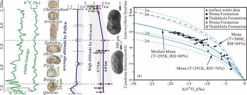
The initial of Neogene sedimentation is related to normal faults along the north-south trending grabens. The Gyirong Basin is sensitive to reveal elevation change in central Himalaya. Analyzing δ18Omw values and correcting catchment elevations for 39 surface water data along the Gyirong River and the Kali Gandaki, a new fitting equation is established. The Δ(δ18Omw) of modern surface waters match very well with previous curve for Rayleigh fractionation with initial T = 295 K and relative humidity = 80 %. Stable isotopic values from modern meteoric water and ostracoda shells are analyzed based on local empirical dataset and the Rayleigh fractionation. In addition to the isotopic data, many pollen data are available to reveal paleoclimatic variation and paleoelevation reconstruction. Both of estimated data documented surface uplift to 6 km since 7.2 Ma and down to 5.3 km during 4.7–3.2 Ma in the central Himalaya, with the underestimate reduction of 550–900 m. Three warm-humid transitions were observed during 7.2–4.7 Ma followed by cooling condition since 4 Ma. The overall uplift history of the Himalaya since 7.2 Ma, underwent an elevation loss phenomenon of the mountain area and an equilibrium position of the basin floor during 4.7–3.2 Ma, which might be as a result of E-W extension and intense weathering and erosion of regional drainage.
喜马拉雅中部现代水和生物化石的稳定同位素作为古海拔和古气候的指示物
新近系沉积的起源与南北向地堑的正断层有关。吉荣盆地是揭示喜马拉雅中部高程变化的敏感盆地。通过对吉隆江和加利甘达基流域39份地表水资料的δ18Omw值的分析和流域高程的校正,建立了新的拟合方程。在初始温度为295 K,相对湿度为80%时,现代地表水的Δ(Δ 18omw)与瑞利分馏曲线吻合较好。基于本地经验数据和瑞利分馏,分析了现代大气水和介形虫壳的稳定同位素值。除了同位素资料外,许多花粉资料可用于揭示古气候变化和古海拔重建。这两个估计数据都记录了喜马拉雅中部地区自7.2 Ma以来地表抬升至6 km,在4.7-3.2 Ma期间下降至5.3 km,低估了550-900 m。在7.2 ~ 4.7 Ma期间经历了3次暖湿过渡,4 Ma之后又经历了降温过程。喜马拉雅地区自7.2 Ma以来的整体隆升历史在4.7 ~ 3.2 Ma期间经历了山区高程下降和盆地底部平衡位置的变化,这可能是东西向伸展和区域流域强烈风化侵蚀的结果。
本文章由计算机程序翻译,如有差异,请以英文原文为准。
求助全文
约1分钟内获得全文
求助全文
来源期刊
CiteScore
5.90
自引率
10.00%
发文量
398
审稿时长
3.8 months
期刊介绍:
Palaeogeography, Palaeoclimatology, Palaeoecology is an international medium for the publication of high quality and multidisciplinary, original studies and comprehensive reviews in the field of palaeo-environmental geology. The journal aims at bringing together data with global implications from research in the many different disciplines involved in palaeo-environmental investigations.
By cutting across the boundaries of established sciences, it provides an interdisciplinary forum where issues of general interest can be discussed.
 求助内容:
求助内容: 应助结果提醒方式:


