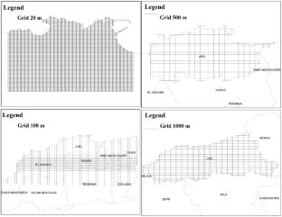
Reanalysis of Historical Earthquakes to Improve Seismic Risk Assessment: A Deterministic Scenario Based on 1856 Djidjelli (Algeria) Tsunamigenic Earthquake
Mouloud Hamidatou, Assia Harbi, Said Maouche, Nassim Hallal
{"title":"Reanalysis of Historical Earthquakes to Improve Seismic Risk Assessment: A Deterministic Scenario Based on 1856 Djidjelli (Algeria) Tsunamigenic Earthquake","authors":"Mouloud Hamidatou, Assia Harbi, Said Maouche, Nassim Hallal","doi":"10.1007/s00024-025-03771-6","DOIUrl":null,"url":null,"abstract":"<div><p>Certain regions of Algeria, particularly in the Northeast, are currently facing heightened seismic activity alongside considerable social and economic challenges. Should a seismic event akin to the Djidjelli (now Jijel) earthquake of August 21 and 22, 1856, strike again, numerous coastal cities may suffer significant damage. This study is part of a broader project aimed at estimating seismic risk and damage levels following seismic events, with a particular focus on initial acceleration computation, which serves as a crucial tool for our modeling. Given the significance of conducting studies that enable the estimation of seismic risk and potential damage in urban agglomerations, the overall goal of this work is to assess seismic risk in an urban agglomeration using a deterministic scenario to estimate the risk, seismic vulnerability and damage potential. We provide a seismic risk scenario for Jijel city, with a particular focus on the susceptibility of its historically significant districts: Bourmel-Ben Achour, Ouled Aissa–Camp Chevalier, and the Old City. Using a Ground Motion Prediction Equation, we calculated the maximum expected ground acceleration based on the following considerations: (a) the 1856 Jijel seismic event as a reference; (b) site impacts associated with the area’s geological characteristics; (c) building damage; and (d) seismic vulnerability. This research presents a Peak Ground Acceleration (PGA) map that incorporates the influence of site lithology (Avib). The highest acceleration was recorded in the city center, with EC8 offering a reliable estimate of acceleration across all three examined areas: Bourmel-Ben Achour, Ouled Aissa–Camp Chevalier, and the Old City. The strongest tremors are felt in Jijel’s city center and eastern regions. Correlation with the geological features reveals an estimated PGA of 0.28 g in the Old Town area. This estimate closely aligns with the PGA of 0.52 g obtained from our independent analysis, which accounts for local lithology and site conditions. Furthermore, according to the RPA (Algerian earthquake engineering code) the Jijel province is classified as Zone IIa (medium seismicity), with an acceleration data of 0.25 g. This study integrates Geographic Information Systems (GIS) data into risk models.</p></div>","PeriodicalId":21078,"journal":{"name":"pure and applied geophysics","volume":"182 8","pages":"3167 - 3191"},"PeriodicalIF":1.9000,"publicationDate":"2025-07-08","publicationTypes":"Journal Article","fieldsOfStudy":null,"isOpenAccess":false,"openAccessPdf":"","citationCount":"0","resultStr":null,"platform":"Semanticscholar","paperid":null,"PeriodicalName":"pure and applied geophysics","FirstCategoryId":"89","ListUrlMain":"https://link.springer.com/article/10.1007/s00024-025-03771-6","RegionNum":4,"RegionCategory":"地球科学","ArticlePicture":[],"TitleCN":null,"AbstractTextCN":null,"PMCID":null,"EPubDate":"","PubModel":"","JCR":"Q2","JCRName":"GEOCHEMISTRY & GEOPHYSICS","Score":null,"Total":0}
引用次数: 0
Abstract
Certain regions of Algeria, particularly in the Northeast, are currently facing heightened seismic activity alongside considerable social and economic challenges. Should a seismic event akin to the Djidjelli (now Jijel) earthquake of August 21 and 22, 1856, strike again, numerous coastal cities may suffer significant damage. This study is part of a broader project aimed at estimating seismic risk and damage levels following seismic events, with a particular focus on initial acceleration computation, which serves as a crucial tool for our modeling. Given the significance of conducting studies that enable the estimation of seismic risk and potential damage in urban agglomerations, the overall goal of this work is to assess seismic risk in an urban agglomeration using a deterministic scenario to estimate the risk, seismic vulnerability and damage potential. We provide a seismic risk scenario for Jijel city, with a particular focus on the susceptibility of its historically significant districts: Bourmel-Ben Achour, Ouled Aissa–Camp Chevalier, and the Old City. Using a Ground Motion Prediction Equation, we calculated the maximum expected ground acceleration based on the following considerations: (a) the 1856 Jijel seismic event as a reference; (b) site impacts associated with the area’s geological characteristics; (c) building damage; and (d) seismic vulnerability. This research presents a Peak Ground Acceleration (PGA) map that incorporates the influence of site lithology (Avib). The highest acceleration was recorded in the city center, with EC8 offering a reliable estimate of acceleration across all three examined areas: Bourmel-Ben Achour, Ouled Aissa–Camp Chevalier, and the Old City. The strongest tremors are felt in Jijel’s city center and eastern regions. Correlation with the geological features reveals an estimated PGA of 0.28 g in the Old Town area. This estimate closely aligns with the PGA of 0.52 g obtained from our independent analysis, which accounts for local lithology and site conditions. Furthermore, according to the RPA (Algerian earthquake engineering code) the Jijel province is classified as Zone IIa (medium seismicity), with an acceleration data of 0.25 g. This study integrates Geographic Information Systems (GIS) data into risk models.
期刊介绍:
pure and applied geophysics (pageoph), a continuation of the journal "Geofisica pura e applicata", publishes original scientific contributions in the fields of solid Earth, atmospheric and oceanic sciences. Regular and special issues feature thought-provoking reports on active areas of current research and state-of-the-art surveys.
Long running journal, founded in 1939 as Geofisica pura e applicata
Publishes peer-reviewed original scientific contributions and state-of-the-art surveys in solid earth and atmospheric sciences
Features thought-provoking reports on active areas of current research and is a major source for publications on tsunami research
Coverage extends to research topics in oceanic sciences
See Instructions for Authors on the right hand side.

 求助内容:
求助内容: 应助结果提醒方式:


