Development of an improved Scaled Drought Condition Index (ISDCI) incorporating soil moisture for drought monitoring in Xinjiang
IF 7
2区 环境科学与生态学
Q1 ENVIRONMENTAL SCIENCES
引用次数: 0
Abstract
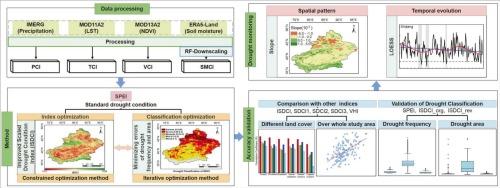
Various composite drought indices have been developed to quantify drought conditions. However, many challenges, such as inadequate soil moisture representation, empirical variable weights, and arbitrary drought classification, still exist. Xinjiang was selected as a typical study area, and an Improved Scaled Drought Condition Index (ISDCI) was developed by integrating precipitation, vegetation, temperature, and downscaled soil moisture with objectively determined weights. Additionally, the classification of drought severity has been refined in a relatively objective way. The results indicate the following: (1) Compared to the Scaled Drought Condition Index (SDCI) and the Vegetation Health Index (VHI), ISDCI showed a higher correlation with the Standardized Precipitation Evapotranspiration Index (SPEI) and the self-calibrating Palmer Drought Severity Index (scPDSI). (2) The optimized drought classification scheme exhibited better alignment with SPEI in terms of drought frequency and drought affected area. (3) Based on ISDCI, Xinjiang experienced an overall drying trend during the 2001–2023 growing seasons. The Ili River Basin dried the fastest (slope = − 8 × 10⁻⁴), while the Tarim River Basin showed the slowest drying trend (slope = −2 × 10⁻⁴). Oases and some mountainous areas became wetter, whereas deserts continued to dry. (4) ISDCI effectively captured major droughts, including those in Xinjiang (2008) and the Ili River Basin (2014). Overall, ISDCI offers high-resolution and near-real-time drought monitoring capabilities, providing scientific support for agricultural management and water resource regulation in arid and semi-arid regions.
基于土壤水分的新疆干旱监测尺度干旱指数(ISDCI)的改进
人们开发了各种综合干旱指数来量化干旱状况。然而,仍然存在许多挑战,如土壤湿度表示不充分、经验变量权重和任意干旱分类。以新疆为典型研究区,将降水、植被、温度和降比例尺土壤水分与客观确定的权重相结合,建立了改进的尺度干旱状况指数(ISDCI)。此外,干旱严重程度的分类也得到了相对客观的改进。结果表明:(1)与标度干旱条件指数(SDCI)和植被健康指数(VHI)相比,ISDCI与标准化降水蒸散指数(SPEI)和自定标Palmer干旱严重指数(scPDSI)的相关性更高。(2)优化后的干旱分类方案在干旱频率和受干旱影响面积方面与SPEI具有较好的一致性。(3)基于ISDCI, 2001-2023年生长季新疆总体呈现干旱趋势。伊犁河干化速度最快(坡度= - 8 × 10⁻⁴),塔里木河干化速度最慢(坡度= - 2 × 10⁻⁴)。绿洲和一些山区变得更加湿润,而沙漠则继续干燥。(4) ISDCI有效捕获了新疆(2008年)和伊犁河流域(2014年)的重大干旱。总体而言,ISDCI提供高分辨率和近实时的干旱监测能力,为干旱和半干旱地区的农业管理和水资源调控提供科学支持。
本文章由计算机程序翻译,如有差异,请以英文原文为准。
求助全文
约1分钟内获得全文
求助全文
来源期刊

Ecological Indicators
环境科学-环境科学
CiteScore
11.80
自引率
8.70%
发文量
1163
审稿时长
78 days
期刊介绍:
The ultimate aim of Ecological Indicators is to integrate the monitoring and assessment of ecological and environmental indicators with management practices. The journal provides a forum for the discussion of the applied scientific development and review of traditional indicator approaches as well as for theoretical, modelling and quantitative applications such as index development. Research into the following areas will be published.
• All aspects of ecological and environmental indicators and indices.
• New indicators, and new approaches and methods for indicator development, testing and use.
• Development and modelling of indices, e.g. application of indicator suites across multiple scales and resources.
• Analysis and research of resource, system- and scale-specific indicators.
• Methods for integration of social and other valuation metrics for the production of scientifically rigorous and politically-relevant assessments using indicator-based monitoring and assessment programs.
• How research indicators can be transformed into direct application for management purposes.
• Broader assessment objectives and methods, e.g. biodiversity, biological integrity, and sustainability, through the use of indicators.
• Resource-specific indicators such as landscape, agroecosystems, forests, wetlands, etc.
 求助内容:
求助内容: 应助结果提醒方式:


