Assessing the spatiotemporal effects of human activity intensity on ecosystem health using VORS and spatial models: Evidence from the e Yellow River Deltaeconomic zone
IF 7.3
2区 环境科学与生态学
Q1 ECOLOGY
引用次数: 0
Abstract
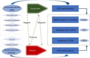
Understanding how coastal human activities influence ecosystem health is critical for sustainable deltaic region management amid rapid industrialization and environmental change. This study evaluates ecosystem health dynamics in China's Yellow River Delta Economic Zone (YRDEZ) from 2005 to 2022 by integrating the Vigor–Organization–Resilience–Services (VORS) model with a Coastal Human Activity Intensity (CHAI) framework incorporating marine aquaculture, petroleum extraction, and port development impacts. The novelty lies in high-resolution (500m) coupling of coastal ecosystem performance with anthropogenic pressures using machine learning algorithms (Random Forest and XGBoost) alongside Geographic Detector and Geographically Weighted Regression to capture saltwater intrusion and sediment dynamics.Findings reveal intensifying negative spatial correlations between CHAI and Ecosystem Health Index (EHI), with coastal urban centers (Dongying, Binzhou) showing highest CHAI and lowest EHI values. Yellow River wetlands exhibit moderate EHI but extreme sensitivity to hydrological modifications. Machine learning models identified salinity gradient, sediment load, and petroleum extraction as dominant explanatory factors (73% variance) for coastal EHI distribution. Aquaculture zones display unique temporal patterns with initial ecosystem enhancement followed by cumulative degradation. A novel Coastal Vulnerability Index successfully predicts ecosystem thresholds with 89% accuracy.Results provide evidence-based guidance for integrated coastal zone management and Blue Economy development in deltaic regions facing industrial expansion and sea-level rise challenges.
基于VORS和空间模型的人类活动强度对生态系统健康的时空影响评价:来自黄河三角洲经济区的证据
在快速工业化和环境变化的背景下,了解沿海人类活动如何影响生态系统健康对三角洲地区的可持续管理至关重要。本研究将活力-组织-弹性-服务(VORS)模型与沿海人类活动强度(CHAI)框架相结合,结合海洋水产养殖、石油开采和港口开发影响,对2005 - 2022年中国黄河三角洲经济区(YRDEZ)生态系统健康动态进行了评估。新颖之处在于使用机器学习算法(Random Forest和XGBoost)以及地理检测器和地理加权回归来捕获盐水入侵和沉积物动态,将沿海生态系统性能与人为压力高分辨率(500米)耦合起来。结果表明,生态系统健康指数(EHI)与CHAI呈负相关,沿海城市中心(东营、滨州)的CHAI最高,EHI最低;黄河湿地表现出中等程度的EHI,但对水文变化极为敏感。机器学习模型确定盐度梯度、沉积物负荷和石油开采是沿海EHI分布的主要解释因素(方差为73%)。水产养殖区表现出独特的时间格局,初始生态系统增强后逐渐退化。一种新的沿海脆弱性指数成功地预测了生态系统阈值,准确率达到89%。研究结果为面临产业扩张和海平面上升挑战的三角洲地区海岸带综合管理和蓝色经济发展提供了循证指导。
本文章由计算机程序翻译,如有差异,请以英文原文为准。
求助全文
约1分钟内获得全文
求助全文
来源期刊

Ecological Informatics
环境科学-生态学
CiteScore
8.30
自引率
11.80%
发文量
346
审稿时长
46 days
期刊介绍:
The journal Ecological Informatics is devoted to the publication of high quality, peer-reviewed articles on all aspects of computational ecology, data science and biogeography. The scope of the journal takes into account the data-intensive nature of ecology, the growing capacity of information technology to access, harness and leverage complex data as well as the critical need for informing sustainable management in view of global environmental and climate change.
The nature of the journal is interdisciplinary at the crossover between ecology and informatics. It focuses on novel concepts and techniques for image- and genome-based monitoring and interpretation, sensor- and multimedia-based data acquisition, internet-based data archiving and sharing, data assimilation, modelling and prediction of ecological data.
 求助内容:
求助内容: 应助结果提醒方式:


