Assessment of the impact of artisanal gold mining on agriculture and natural resources using Landsat imagery - A case study on Central Côte d'Ivoire
IF 3.3
Q2 MULTIDISCIPLINARY SCIENCES
引用次数: 0
Abstract
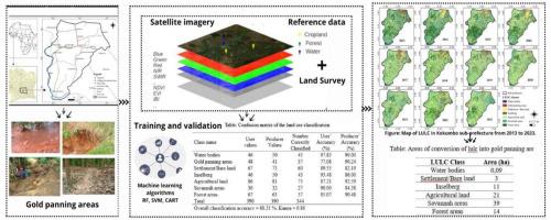
With gold mining booming in Côte d'Ivoire, the environmental and socio-economic impacts have become a cause for concern. Between 2013 and 2023, the sub-prefecture of Kokumbo, in central Côte d'Ivoire, was subject to illegal and uncontrolled gold mining. The aim of this study was to assess the impact of this exploitation on natural resources (forests, savannahs, and water) and agriculture. To achieve this objective, Landsat satellite images were analyzed using machine learning algorithms to perform supervised classification. This approach was used to map and quantify changes in land use and land cover over the study period. The “random forest” algorithm provided the best classification and was used for the classification of the time series of Landsat images. The results indicated a regression of 14.64 % of forest areas, 7.12 % of savannah areas, 0.14 and 0.03 % of water bodies and an increase of 19.89 % of agricultural land. Approximately 89 ha (or 0.21 %) of the surface area of the Kokumbo sub-prefecture were converted into gold mining areas. This conversion concerned 40 ha of savannah areas, 21 ha of agricultural land, 14 ha of forest areas, 11 ha of inselbergs and 3 ha of bare areas. In conclusion, artisanal gold mining has been a key driver of land use change dynamics, affecting agricultural lands and natural ecosystems. These impacts could compromise ecosystem services on which local communities depend.
利用陆地卫星图像评估手工采金对农业和自然资源的影响-以中部Côte科特迪瓦为例
随着黄金开采在Côte科特迪瓦的蓬勃发展,其对环境和社会经济的影响已成为一个令人担忧的问题。2013年至2023年期间,位于Côte科特迪瓦中部的科昆博(Kokumbo)副州遭受了非法和不受控制的金矿开采。这项研究的目的是评估这种开发对自然资源(森林、稀树草原和水)和农业的影响。为了实现这一目标,Landsat卫星图像使用机器学习算法进行分析,以执行监督分类。该方法用于绘制和量化研究期间土地利用和土地覆盖的变化。“随机森林”算法分类效果最好,可用于Landsat影像时间序列的分类。结果表明,森林面积减少14.64%,草原面积减少7.12%,水体面积分别减少0.14%和0.03%,农用地面积增加19.89%。Kokumbo县约89公顷(0.21%)的地表面积被改造为金矿矿区。这一转变涉及40公顷草原、21公顷农业用地、14公顷森林、11公顷灌木和3公顷光秃秃的地区。综上所述,手工金矿开采是土地利用变化动态的关键驱动因素,影响着农业用地和自然生态系统。这些影响可能损害当地社区所依赖的生态系统服务。
本文章由计算机程序翻译,如有差异,请以英文原文为准。
求助全文
约1分钟内获得全文
求助全文
来源期刊

Scientific African
Multidisciplinary-Multidisciplinary
CiteScore
5.60
自引率
3.40%
发文量
332
审稿时长
10 weeks
 求助内容:
求助内容: 应助结果提醒方式:


