Revisiting surface ruptures of the 1955 Zheduotang earthquake (Mw 7.1) in eastern tibet: kinematic implications on the southern Xianshuihe fault zone
IF 2.9
2区 地球科学
Q2 GEOSCIENCES, MULTIDISCIPLINARY
引用次数: 0
Abstract
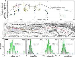
Surface ruptures associated with large historical earthquakes provide essential insights into earthquake magnitudes and the kinematics of their seismogenic faults. In 1955, a major earthquake struck Zheduotang Village, Kangding City, producing surface ruptures along the Zheduotang fault, a segment of the southern Xianshuihe fault zone. The magnitude of this event remains a topic of debate, with estimates ranging from M6.6 to M7.5, primarily due to discrepancies in the interpretation of its associated surface ruptures. This study synthesizes previous research on the surface ruptures of the 1955 Zheduotang earthquake and presents new field data, including high-resolution unmanned aerial vehicle (UAV)-based topographic surveys, trenching, and lichenometry in the epicentral region. Analysis of surface rupture freshness, faulting event chronology from trenching, and lichen size measurements collectively support a ∼55 km-long surface rupture zone, corresponding to a moment magnitude (Mw) of ∼7.1 for the 1955 earthquake. Offset glacial landform analysis reveals a late Quaternary left-lateral slip rate of ∼2.5–3.0 mm/yr in the southern segment of the Zheduotang fault, which is lower than the previously documented ∼4 mm/yr in the northern segment. Deformed landforms and surface ruptures indicate that the fault trends NNW and exhibits predominantly left-lateral strike-slip motion in its northern segment, while the southern segment trends NW and includes a notable normal faulting component. Our findings suggest that the Zheduotang fault defines the southwestern boundary of the Bamei-Kangding releasing stepover zone within the southern Xianshuihe left-lateral strike-slip fault zone. These results enhance the understanding of seismic hazards and the tectonic kinematics along the eastern boundary of the Tibetan Plateau.
重访1955年7级浙多塘地震的地表破裂。
与历史上大地震有关的地表破裂为了解地震震级及其发震断层的运动学提供了重要的见解。1955年,康定市哲多塘村发生大地震,鲜水河断裂带南段哲多塘断裂带发生地表破裂。这次地震的震级仍然是一个有争议的话题,估计的震级从6.6级到7.5级不等,主要是由于对其相关地表破裂的解释存在差异。本文综合了前人对1955年哲多塘地震地表破裂的研究成果,提出了新的野外资料,包括基于无人机的高分辨率地形测量、沟槽测量和震源区域地坪测量。对地表破裂新鲜度的分析、来自沟槽的断层事件年代学和地衣尺寸的测量结果共同支持一个~ 55公里长的地表破裂带,对应于1955年地震的力矩震级(Mw)为~ 7.1。偏置冰川地貌分析表明,浙多塘断裂南段晚第四纪左侧滑动速率为~ 2.5 ~ 3.0 mm/yr,低于之前记录的北段~ 4 mm/yr。变形地貌和地表断裂特征表明,断层走向NNW,北段以左侧走滑运动为主,南段走向NW,包含明显的正断层成分。研究结果表明,鲜水河左侧走滑断裂带南段的八美-康定释放阶梯带西南边界为哲多塘断裂。
本文章由计算机程序翻译,如有差异,请以英文原文为准。
求助全文
约1分钟内获得全文
求助全文
来源期刊
Journal of Structural Geology
地学-地球科学综合
CiteScore
6.00
自引率
19.40%
发文量
192
审稿时长
15.7 weeks
期刊介绍:
The Journal of Structural Geology publishes process-oriented investigations about structural geology using appropriate combinations of analog and digital field data, seismic reflection data, satellite-derived data, geometric analysis, kinematic analysis, laboratory experiments, computer visualizations, and analogue or numerical modelling on all scales. Contributions are encouraged to draw perspectives from rheology, rock mechanics, geophysics,metamorphism, sedimentology, petroleum geology, economic geology, geodynamics, planetary geology, tectonics and neotectonics to provide a more powerful understanding of deformation processes and systems. Given the visual nature of the discipline, supplementary materials that portray the data and analysis in 3-D or quasi 3-D manners, including the use of videos, and/or graphical abstracts can significantly strengthen the impact of contributions.
 求助内容:
求助内容: 应助结果提醒方式:


