Distribution of arsenic concentrations in soils historically impacted by mining activities: Cross-validation of pXRF methodology and application to the Orbiel valley (France)
IF 5.7
1区 农林科学
Q1 GEOSCIENCES, MULTIDISCIPLINARY
引用次数: 0
Abstract
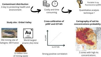
Understanding contaminant distribution in industrial and mining areas is essential for protecting human health and the environment, although traditional mapping methods are costly and time-consuming. This study aims to provide, using portable X-ray fluorescence (pXRF), rigorous maps of soil As concentrations over the Orbiel valley, historically impacted by mining activities since several decades. After a cross-calibration of pXRF with ICP-MS, we mapped As distribution in topsoils, and investigated factors influencing As dispersion. Two field campaigns were conducted: one targeting riverbanks and floodplains, the other on a 1 x 1 km grid over a 10 km radius from pollution sources. Spatial mapping identified three zones with high As concentrations (193–342 mg kg−1), exceeding background levels (44 mg kg−1), with floodplains particularly impacted (178 mg kg−1), likely due to transport processes. Our findings confirm pXRF as a powerful tool for rapid, high-resolution As contamination screening in post-mining contexts. Cross-calibration showed no significant differences between pXRF and ICP-MS (Kruskal-Wallis, p > 0.05) and strong correlations (Pearson R > 0.90). Optimal pXRF modes (Soil, TestAllGeo and Mining modes) ensured accurate measurements of As, Pb, Mn, and Zn. Finally, the maps of As distribution over the valley, as well as Pb isotopic data in the different environmental compartments, suggest both a local origin of this contamination and the influence of rivers but above all atmosphere in As dispersion.
受采矿活动历史影响的土壤中砷浓度分布:pXRF方法的交叉验证及其在Orbiel山谷的应用(法国)
了解工业和矿区的污染物分布对于保护人类健康和环境至关重要,尽管传统的测绘方法既昂贵又耗时。这项研究旨在利用便携式x射线荧光(pXRF)提供严格的轨道谷土壤砷浓度图,几十年来一直受到采矿活动的影响。通过与ICP-MS的交叉校准,我们绘制了砷在表层土壤中的分布,并研究了影响砷分散的因素。开展了两项实地调查:一项针对河岸和洪泛平原,另一项针对污染源半径10公里范围内的1 × 1公里网格。空间测绘确定了三个砷浓度高的区域(193-342 mg kg - 1),超过了背景水平(44 mg kg - 1),洪泛区受到的影响特别大(178 mg kg - 1),可能是由于运输过程。我们的研究结果证实,pXRF是采矿后环境中快速、高分辨率砷污染筛查的有力工具。交叉校准显示pXRF与ICP-MS之间无显著差异(Kruskal-Wallis, p > 0.05),且具有强相关性(Pearson R > 0.90)。最佳的pXRF模式(Soil, TestAllGeo和Mining模式)确保了As, Pb, Mn和Zn的准确测量。最后,砷在山谷中的分布图,以及不同环境区室的铅同位素数据,都表明了这种污染的当地起源和河流的影响,但最重要的是大气对砷扩散的影响。
本文章由计算机程序翻译,如有差异,请以英文原文为准。
求助全文
约1分钟内获得全文
求助全文
来源期刊

Catena
环境科学-地球科学综合
CiteScore
10.50
自引率
9.70%
发文量
816
审稿时长
54 days
期刊介绍:
Catena publishes papers describing original field and laboratory investigations and reviews on geoecology and landscape evolution with emphasis on interdisciplinary aspects of soil science, hydrology and geomorphology. It aims to disseminate new knowledge and foster better understanding of the physical environment, of evolutionary sequences that have resulted in past and current landscapes, and of the natural processes that are likely to determine the fate of our terrestrial environment.
Papers within any one of the above topics are welcome provided they are of sufficiently wide interest and relevance.
 求助内容:
求助内容: 应助结果提醒方式:


