Global 20-year time series of XCO2 concentrations derived from satellite observations and interpolations to analyze XCO2 anomalies caused by wildfires
IF 4.4
2区 地球科学
Q1 METEOROLOGY & ATMOSPHERIC SCIENCES
引用次数: 0
Abstract
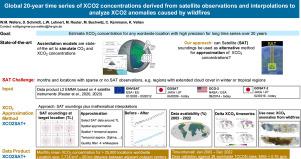
Accurate, long-term records of atmospheric CO concentrations are crucial for understanding carbon cycle dynamics and evaluating the impacts of natural and anthropogenic emissions. In this study, we present a global dataset of column-averaged CO concentrations (XCO) covering the period 2003–2022, generated using an enhanced version of the XCO2SAT+ method. This approach integrates satellite observations from four missions (ENVISAT, GOSAT, GOSAT, GOSAT-2 and OCO-2) harmonized through the EMMA v4.5 product, and applies a novel spatio-temporal interpolation algorithm to estimate monthly mean XCO values at 23 958 locations worldwide (95 km grid spacing). The dataset provides XCO estimates over global land surfaces and adjacent coastal regions. Validation against 28 TCCON sites yielded a mean absolute error (MAE) of , comparable to NOAA’s CarbonTracker model (). The method reliably reconstructs XCO time series even in regions with sparse satellite coverage, while preserving spatial and seasonal variability. As a demonstration, we identify XCO anomalies linked to major wildfire events, including North American mega-fires in 2018 and recurring fire activity in tropical northern Africa, with localized monthly anomalies exceeding 2 ppm–4 ppm. Comparison with recent machine learning (ML) products confirms that the XCO2SAT+ method achieves higher accuracy across multiple TCCON sites and time frames. This semi-empirical dataset provides a valuable alternative to assimilation-based models, supporting climate research, emission monitoring, and the detection of CO perturbations from extreme events at high spatial and temporal resolution.
全球20年XCO2浓度时间序列的卫星观测和插值分析野火引起的XCO2异常
准确、长期的大气CO2浓度记录对于理解碳循环动力学和评估自然和人为排放的影响至关重要。在这项研究中,我们提供了一个覆盖2003-2022年期间的柱平均CO2浓度(XCO2)的全球数据集,该数据集使用XCO2SAT+方法的增强版本生成。该方法整合了通过EMMA v4.5产品协调的四个任务(ENVISAT、GOSAT、GOSAT、GOSAT-2和OCO-2)的卫星观测数据,并应用一种新的时空插值算法估算全球23958个地点(≈95 km网格间距)的月平均XCO2值。该数据集提供了全球陆地表面和邻近沿海地区的XCO2估计值。对28个TCCON站点的验证得出的平均绝对误差(MAE)为0.76ppm,与NOAA的CarbonTracker模型(MAE=0.71ppm)相当。即使在卫星覆盖稀疏的地区,该方法也能可靠地重建XCO2时间序列,同时保持空间和季节变化。作为示范,我们确定了与重大野火事件相关的XCO2异常,包括2018年北美的特大火灾和热带北非的反复火灾活动,局部月度异常超过2 ppm - 4 ppm。与最近的机器学习(ML)产品的比较证实,XCO2SAT+方法在多个TCCON站点和时间范围内实现了更高的准确性。该半经验数据集为基于同化的模型提供了有价值的替代方案,支持气候研究、排放监测和高时空分辨率极端事件CO2扰动检测。
本文章由计算机程序翻译,如有差异,请以英文原文为准。
求助全文
约1分钟内获得全文
求助全文
来源期刊
Atmospheric Research
地学-气象与大气科学
CiteScore
9.40
自引率
10.90%
发文量
460
审稿时长
47 days
期刊介绍:
The journal publishes scientific papers (research papers, review articles, letters and notes) dealing with the part of the atmosphere where meteorological events occur. Attention is given to all processes extending from the earth surface to the tropopause, but special emphasis continues to be devoted to the physics of clouds, mesoscale meteorology and air pollution, i.e. atmospheric aerosols; microphysical processes; cloud dynamics and thermodynamics; numerical simulation, climatology, climate change and weather modification.
 求助内容:
求助内容: 应助结果提醒方式:


