Geomorphological responses to climate change in the Ganges-Brahmaputra-Meghna Delta: A multi-decadal remote sensing analysis
IF 2.2
Q2 GEOGRAPHY, PHYSICAL
引用次数: 0
Abstract
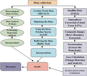
The Ganges-Brahmaputra-Meghna (GBM) Delta represents a major riverine system with limited data availability. This study investigates the morphodynamic behavior of the delta and estuary from 1990 to 2021 by analyzing time-series satellite imagery and comprehensive literature to identify key events and driving factors. The aims of this study are to better understand the geomorphological processes that influence the GBM delta system, identify the physical factors contributing to its formation and, predict future challenges for sustainable development in delta areas. Climatological data (temperature and rainfall) from NASA revealed a rising trend in average annual temperature and fluctuating rainfall patterns across five sites in GBM river system: Sirajganj, Tangail, Rajbari, Chandpur, and Bhola. Cyclone track data were analyzed, and GIS mapping of cyclone intensity and trajectories in the GBM delta was conducted to predict future sustainability challenges. Multi-temporal Landsat imagery from USGS Earth Explorer was analyzed using ArcGIS 10.8 to assess riverbank erosion and accretion. Erosion, accretion, and stable land areas varied across five sites of GBM delta from 1990 to 2020. Sirajgonj and Tangail show major land gains until 2010, followed by severe erosion in 2010–2020, with net losses of −404.33 km2 and -497.69 km2, respectively. Rajbari gained (+234.66 km2) land in 2000–2010 but saw a reversal with a −143.75 km2 loss in the next decade. Chandpur had consistent gains until 2010 but a slight loss (−11.8 km2) afterward. Bhola remained the most stable, maintaining continuous net gains, peaking at +76.83 km2 in 2010–2020. NDVI, NDWI, and NDSI data reveals a river-wise gradient. NDVI peaks along the Brahmaputra/Jamuna and Ganges/Padma floodplains and declines toward the Meghna estuary. NDWI delineates persistent surface water, while NDSI shows seaward-intensifying salinity toward the Meghna, indicating elevated coastal vulnerability.These findings serve as a guideline to clarify cause-and-effect relationships in global climate change and anticipate future challenges to the sustainable development of the delta.
恒河-布拉马普特拉河-梅克纳三角洲地貌对气候变化的响应:多年遥感分析
恒河-布拉马普特拉河-梅克纳河三角洲(GBM)是一个主要的河流系统,但数据有限。通过分析时间序列卫星图像和综合文献,研究了1990 - 2021年三角洲和河口的形态动力学行为,找出了关键事件和驱动因素。本研究的目的是更好地了解影响GBM三角洲系统的地貌过程,确定促进其形成的物理因素,并预测三角洲地区可持续发展的未来挑战。美国国家航空航天局的气候数据(温度和降雨量)显示,GBM河系统的五个地点(Sirajganj、Tangail、Rajbari、Chandpur和Bhola)的年平均气温和波动降雨模式呈上升趋势。分析了气旋路径数据,并对GBM三角洲的气旋强度和轨迹进行了GIS制图,以预测未来的可持续性挑战。利用ArcGIS 10.8对USGS地球探测器的多时相Landsat图像进行分析,以评估河岸侵蚀和增生。1990 - 2020年,GBM三角洲5个站点的侵蚀、增生和稳定土地面积发生了变化。Sirajgonj和Tangail在2010年之前土地收益显著,随后在2010 - 2020年遭受严重侵蚀,净损失分别为- 404.33 km2和-497.69 km2。Rajbari在2000-2010年增加了234.66 km2的土地,但在接下来的十年中出现了逆转,减少了143.75 km2。钱普尔在2010年之前持续增长,但之后略有减少(- 11.8平方公里)。Bhola保持最稳定,保持了连续的净增长,在2010-2020年达到76.83平方公里的峰值。NDVI、NDWI和NDSI数据显示了河流方向的梯度。NDVI沿雅鲁藏布江/贾穆纳河和恒河/帕德玛洪泛平原达到峰值,向梅克纳河河口下降。NDWI描绘了持续的地表水,而NDSI显示了向梅克纳河方向的海水盐度增加,表明沿海地区的脆弱性增加。研究结果可为厘清全球气候变化的因果关系和预测未来三角洲可持续发展面临的挑战提供指导。
本文章由计算机程序翻译,如有差异,请以英文原文为准。
求助全文
约1分钟内获得全文
求助全文
来源期刊
Quaternary Science Advances
Earth and Planetary Sciences-Earth-Surface Processes
CiteScore
4.00
自引率
13.30%
发文量
16
审稿时长
61 days
 求助内容:
求助内容: 应助结果提醒方式:


