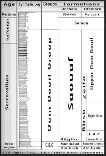
{"title":"Application of the sequence stratigraphy approach to assess the hydrological potentiality of siliciclastic Miocene reservoir, North-Eastern Tunisia","authors":"Ramzi Gharsalli, Hajer Azaiez","doi":"10.1007/s11600-025-01600-x","DOIUrl":null,"url":null,"abstract":"<div><p>In the Cap Bon Peninsula, to the north-eastern part of Tunisia, the Miocene siliciclastic deposits constitute the main source for drinking and irrigation water. Nevertheless, the recognition of the subsurface lateral distribution and facies variation, of these deposits, need to be improved. The methodology we adopted, to investigate these reservoir levels, was based on a detailed outcrop survey of several lithostratigraphic sections in the Jebel Abderrahmane area, associated to the interpretation of key subsurface seismic reflection profiles calibrated to petroleum well data. The combination of several exploration techniques and analysis tools, such as sequence stratigraphy, wireline logging records, seismic data and lithostratigraphic cross sections, enabled to identify the Miocene depositional sequence organization on outcrops. It also allowed us to characterize the sandy levels likely to constitute potential reservoirs and to perceive their equivalents in subsurface. The lithostratigraphic cross-sectional survey carried out around Jebel Abderrahmane area shows only five third-order depositional sequences, separated by regional chronological surfaces. Through these lithostratigraphic sections, we have identified five potential siliciclastic reservoirs. Most of them are represented by lowstand system tract deposits. The sequence stratigraphic analysis, of subsurface Miocene series, was performed using several seismic lines calibrated to petroleum well data. These series are commonly more complete in grabens and syncline gutters, in which seven third-order Miocene seismic sequences and six associated potential reservoirs have been identified. The chronostratigraphic correlations of the Miocene deposits on according lithostratigraphic sections were based on regional key sequence stratigraphic surfaces, instead of commonly used geological formation tops. These correlation profiles reveal significant thickness and facies variations of the Miocene deposits induced by the tectonic activity. The latter puts in place two distinct depositional environments on both sides of Jebel Abderrahmane, in which the Miocene aquifers show different hydrogeological characteristics. Recent hydrogeological studies in the area prove the importance of the subsurface Oligo-Miocene sandstones as potential aquifers with significant groundwater reserves. </p></div>","PeriodicalId":6988,"journal":{"name":"Acta Geophysica","volume":"73 5","pages":"4259 - 4276"},"PeriodicalIF":2.1000,"publicationDate":"2025-06-06","publicationTypes":"Journal Article","fieldsOfStudy":null,"isOpenAccess":false,"openAccessPdf":"","citationCount":"0","resultStr":null,"platform":"Semanticscholar","paperid":null,"PeriodicalName":"Acta Geophysica","FirstCategoryId":"89","ListUrlMain":"https://link.springer.com/article/10.1007/s11600-025-01600-x","RegionNum":4,"RegionCategory":"地球科学","ArticlePicture":[],"TitleCN":null,"AbstractTextCN":null,"PMCID":null,"EPubDate":"","PubModel":"","JCR":"","JCRName":"","Score":null,"Total":0}
引用次数: 0
Abstract
In the Cap Bon Peninsula, to the north-eastern part of Tunisia, the Miocene siliciclastic deposits constitute the main source for drinking and irrigation water. Nevertheless, the recognition of the subsurface lateral distribution and facies variation, of these deposits, need to be improved. The methodology we adopted, to investigate these reservoir levels, was based on a detailed outcrop survey of several lithostratigraphic sections in the Jebel Abderrahmane area, associated to the interpretation of key subsurface seismic reflection profiles calibrated to petroleum well data. The combination of several exploration techniques and analysis tools, such as sequence stratigraphy, wireline logging records, seismic data and lithostratigraphic cross sections, enabled to identify the Miocene depositional sequence organization on outcrops. It also allowed us to characterize the sandy levels likely to constitute potential reservoirs and to perceive their equivalents in subsurface. The lithostratigraphic cross-sectional survey carried out around Jebel Abderrahmane area shows only five third-order depositional sequences, separated by regional chronological surfaces. Through these lithostratigraphic sections, we have identified five potential siliciclastic reservoirs. Most of them are represented by lowstand system tract deposits. The sequence stratigraphic analysis, of subsurface Miocene series, was performed using several seismic lines calibrated to petroleum well data. These series are commonly more complete in grabens and syncline gutters, in which seven third-order Miocene seismic sequences and six associated potential reservoirs have been identified. The chronostratigraphic correlations of the Miocene deposits on according lithostratigraphic sections were based on regional key sequence stratigraphic surfaces, instead of commonly used geological formation tops. These correlation profiles reveal significant thickness and facies variations of the Miocene deposits induced by the tectonic activity. The latter puts in place two distinct depositional environments on both sides of Jebel Abderrahmane, in which the Miocene aquifers show different hydrogeological characteristics. Recent hydrogeological studies in the area prove the importance of the subsurface Oligo-Miocene sandstones as potential aquifers with significant groundwater reserves.
期刊介绍:
Acta Geophysica is open to all kinds of manuscripts including research and review articles, short communications, comments to published papers, letters to the Editor as well as book reviews. Some of the issues are fully devoted to particular topics; we do encourage proposals for such topical issues. We accept submissions from scientists world-wide, offering high scientific and editorial standard and comprehensive treatment of the discussed topics.


 求助内容:
求助内容: 应助结果提醒方式:


