{"title":"Land subsidence site investigated by combining active and passive MASW methods: a case study from central Taiwan","authors":"Jia-Wei Liu, Young-Fo Chang, Hao Kuo-Chen","doi":"10.1007/s11600-025-01639-w","DOIUrl":null,"url":null,"abstract":"<div><p>Land subsidence presents significant infrastructure risks in central Taiwan due to the region’s young and weak strata. This study addresses the differential subsidence impacting a railway section by integrating of borehole data, electrical resistivity tomography (ERT) and multi-channel analysis of surface waves (MASW) methods. Limited by spread lengths, traditional ERT and active MASW are confined to shallow subsurface analysis. Our approach enhances depth investigation by combining passive MASW, which captures low-frequency data for deeper geological insights. A 131 m-long active and passive MASW surveys was conducted alongside the railway. The analysis of dispersion curves from both MASW methods showed consistent phase velocities across overlapping frequency ranges, confirming the approach’s reliability. Ambient noise analysis further validated that passive MASW could generate stable dispersion curves within 1 h under various conditions, such as day, night, and during train activities. Geophysical images revealed that the differential subsidence is primarily driven by variations in subsurface material properties. Integrating geophysical and lithological data identified a previously undetected critical soft sand layer at 11–20 m depth as a major subsidence factor. This study not only underscores the effectiveness of passive MASW but also highlights the significant benefits of combining geophysical methods. The integrated interpretation helps to characterize the identification of subsidence cause, a crucial step in improving mitigation strategy for infrastructure risks.</p></div>","PeriodicalId":6988,"journal":{"name":"Acta Geophysica","volume":"73 5","pages":"4339 - 4355"},"PeriodicalIF":2.1000,"publicationDate":"2025-07-01","publicationTypes":"Journal Article","fieldsOfStudy":null,"isOpenAccess":false,"openAccessPdf":"","citationCount":"0","resultStr":null,"platform":"Semanticscholar","paperid":null,"PeriodicalName":"Acta Geophysica","FirstCategoryId":"89","ListUrlMain":"https://link.springer.com/article/10.1007/s11600-025-01639-w","RegionNum":4,"RegionCategory":"地球科学","ArticlePicture":[],"TitleCN":null,"AbstractTextCN":null,"PMCID":null,"EPubDate":"","PubModel":"","JCR":"","JCRName":"","Score":null,"Total":0}
引用次数: 0
Abstract
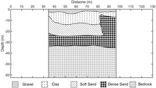
Land subsidence presents significant infrastructure risks in central Taiwan due to the region’s young and weak strata. This study addresses the differential subsidence impacting a railway section by integrating of borehole data, electrical resistivity tomography (ERT) and multi-channel analysis of surface waves (MASW) methods. Limited by spread lengths, traditional ERT and active MASW are confined to shallow subsurface analysis. Our approach enhances depth investigation by combining passive MASW, which captures low-frequency data for deeper geological insights. A 131 m-long active and passive MASW surveys was conducted alongside the railway. The analysis of dispersion curves from both MASW methods showed consistent phase velocities across overlapping frequency ranges, confirming the approach’s reliability. Ambient noise analysis further validated that passive MASW could generate stable dispersion curves within 1 h under various conditions, such as day, night, and during train activities. Geophysical images revealed that the differential subsidence is primarily driven by variations in subsurface material properties. Integrating geophysical and lithological data identified a previously undetected critical soft sand layer at 11–20 m depth as a major subsidence factor. This study not only underscores the effectiveness of passive MASW but also highlights the significant benefits of combining geophysical methods. The integrated interpretation helps to characterize the identification of subsidence cause, a crucial step in improving mitigation strategy for infrastructure risks.
期刊介绍:
Acta Geophysica is open to all kinds of manuscripts including research and review articles, short communications, comments to published papers, letters to the Editor as well as book reviews. Some of the issues are fully devoted to particular topics; we do encourage proposals for such topical issues. We accept submissions from scientists world-wide, offering high scientific and editorial standard and comprehensive treatment of the discussed topics.

 求助内容:
求助内容: 应助结果提醒方式:


