{"title":"Groynes in riverbank erosion control: an integrated hydrodynamic and morphodynamic modelling for a selected reach of the Padma river","authors":"Shadman Shahariar, Nahid Sultana, Hasan Zobeyer","doi":"10.1007/s12665-025-12497-6","DOIUrl":null,"url":null,"abstract":"<div><p>The Padma River, a highly dynamic system characterized by intense bank erosion and rapid morphological changes, presents significant challenges to riverbank stability and infrastructure. Despite the widespread use of groyne-type structures for riverbank protection, their performance under varying configurations in such dynamic environments remains under-explored. Therefore, this study contributes to the advancement of existing knowledge by quantitatively analyzing the performance of multiple groyne configurations under varying flood scenarios using a high-resolution hydro-morphological modeling approach. Historical planform analysis indicates severe bank retreat, with 1,510 m of erosion recorded between 1988 and 1993 and 810 m between 2018 and 2023, driven by increased meandering and higher sinuosity. A high-resolution Delft3D Domain Decomposition (DD) model was developed through a sensitivity analysis and calibrated using 2018 monsoon (June–September) data at Mawa station, achieving very good accuracy in both water level and discharge simulations. Simulations are undertaken to assess the effectiveness of groyne interventions under 10-, 50-, and 100-year flood events. Four simulation scenarios were tested: a base condition without groynes and three alternative configurations featuring three, four, and seven groynes installed across erosion-prone zones. Analysis of the simulation results revealed that the configuration with seven groynes effectively redirected high-velocity flows away from vulnerable banks, substantially reducing near-bank velocities and bed shear stresses, and minimizing riverbed scour depths during extreme events. The findings underscore the critical importance of optimized groyne placement for enhancing riverbank stability in dynamic river systems subject to intensified climate-driven flood risks.</p></div>","PeriodicalId":542,"journal":{"name":"Environmental Earth Sciences","volume":"84 16","pages":""},"PeriodicalIF":2.8000,"publicationDate":"2025-08-14","publicationTypes":"Journal Article","fieldsOfStudy":null,"isOpenAccess":false,"openAccessPdf":"","citationCount":"0","resultStr":null,"platform":"Semanticscholar","paperid":null,"PeriodicalName":"Environmental Earth Sciences","FirstCategoryId":"93","ListUrlMain":"https://link.springer.com/article/10.1007/s12665-025-12497-6","RegionNum":4,"RegionCategory":"环境科学与生态学","ArticlePicture":[],"TitleCN":null,"AbstractTextCN":null,"PMCID":null,"EPubDate":"","PubModel":"","JCR":"Q3","JCRName":"ENVIRONMENTAL SCIENCES","Score":null,"Total":0}
引用次数: 0
Abstract
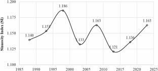
The Padma River, a highly dynamic system characterized by intense bank erosion and rapid morphological changes, presents significant challenges to riverbank stability and infrastructure. Despite the widespread use of groyne-type structures for riverbank protection, their performance under varying configurations in such dynamic environments remains under-explored. Therefore, this study contributes to the advancement of existing knowledge by quantitatively analyzing the performance of multiple groyne configurations under varying flood scenarios using a high-resolution hydro-morphological modeling approach. Historical planform analysis indicates severe bank retreat, with 1,510 m of erosion recorded between 1988 and 1993 and 810 m between 2018 and 2023, driven by increased meandering and higher sinuosity. A high-resolution Delft3D Domain Decomposition (DD) model was developed through a sensitivity analysis and calibrated using 2018 monsoon (June–September) data at Mawa station, achieving very good accuracy in both water level and discharge simulations. Simulations are undertaken to assess the effectiveness of groyne interventions under 10-, 50-, and 100-year flood events. Four simulation scenarios were tested: a base condition without groynes and three alternative configurations featuring three, four, and seven groynes installed across erosion-prone zones. Analysis of the simulation results revealed that the configuration with seven groynes effectively redirected high-velocity flows away from vulnerable banks, substantially reducing near-bank velocities and bed shear stresses, and minimizing riverbed scour depths during extreme events. The findings underscore the critical importance of optimized groyne placement for enhancing riverbank stability in dynamic river systems subject to intensified climate-driven flood risks.
期刊介绍:
Environmental Earth Sciences is an international multidisciplinary journal concerned with all aspects of interaction between humans, natural resources, ecosystems, special climates or unique geographic zones, and the earth:
Water and soil contamination caused by waste management and disposal practices
Environmental problems associated with transportation by land, air, or water
Geological processes that may impact biosystems or humans
Man-made or naturally occurring geological or hydrological hazards
Environmental problems associated with the recovery of materials from the earth
Environmental problems caused by extraction of minerals, coal, and ores, as well as oil and gas, water and alternative energy sources
Environmental impacts of exploration and recultivation – Environmental impacts of hazardous materials
Management of environmental data and information in data banks and information systems
Dissemination of knowledge on techniques, methods, approaches and experiences to improve and remediate the environment
In pursuit of these topics, the geoscientific disciplines are invited to contribute their knowledge and experience. Major disciplines include: hydrogeology, hydrochemistry, geochemistry, geophysics, engineering geology, remediation science, natural resources management, environmental climatology and biota, environmental geography, soil science and geomicrobiology.


 求助内容:
求助内容: 应助结果提醒方式:


