Systematic overestimation of urban Parks’ cooling effects may mislead heat-governance-oriented park planning
IF 9.2
1区 环境科学与生态学
Q1 ECOLOGY
引用次数: 0
Abstract
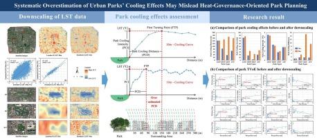
Urban parks play a crucial role in mitigating the urban heat island effect, and their cooling effects have been widely studied. However, data resolution limitations hinder the accurate capture of micro-scale temperature variations, leading to assessment biases. This study analyzed 36 parks within Beijing’s Fourth Ring Road, employing a downscaling model based on Landsat 8 and Sentinel-2 imagery to generate high-resolution land surface temperature (LST) data. Using maximum and cumulative cooling indicators alongside an improved threshold value of efficiency (TVoE) method, we examined how enhanced data resolution influences park cooling assessment outcomes. Results indicated that low-resolution LST data fail to accurately capture the first turning point (FTP) of the cooling curve, leading to varying degrees of overestimation in park cooling effects depending on the cooling indicator and park size. Specifically, park cooling distance (PCD), area (PCA), and efficiency (PCE) were overestimated by factors of 2.35, 1.80, and 6.21, respectively, with smaller parks showing more pronounced biases. Conversely, park cooling intensity (PCI) remained stable across resolutions. This anomaly may obscure overestimation issues and lead to underestimation of the TVoE (with the PCI-based TVoE being significantly lower than that derived from PCD and PCA), thereby misleading the practical planning, hindering the precise implementation of heat governance policies, and weakening the effectiveness of urban heat risk management. Therefore, future research should prioritize verifying PCD accuracy refine both data resolution and methodology to improve the precision of park cooling assessments, thereby providing more scientifically grounded guidance for urban park planning aimed at heat governance.
系统地高估城市公园的降温效果可能会误导以热治理为导向的公园规划
城市公园在缓解城市热岛效应中起着至关重要的作用,其降温效应得到了广泛的研究。然而,数据分辨率的限制阻碍了对微尺度温度变化的准确捕获,导致评估偏差。本研究分析了北京四环内的36个公园,采用基于Landsat 8和Sentinel-2图像的降尺度模型生成高分辨率地表温度(LST)数据。使用最大和累积冷却指标以及改进的效率阈值(TVoE)方法,我们研究了增强的数据分辨率如何影响公园冷却评估结果。结果表明,低分辨率地表温度数据不能准确捕捉降温曲线的第一拐点(FTP),导致不同降温指标和公园规模对公园降温效果有不同程度的高估。其中,公园冷却距离(PCD)、面积(PCA)和效率(PCE)分别被高估了2.35、1.80和6.21倍,且公园规模越小,偏差越明显。相反,公园冷却强度(PCI)在不同分辨率下保持稳定。这种异常可能会掩盖高估的问题,导致对TVoE的低估(基于pci的TVoE明显低于PCD和PCA的TVoE),从而误导实际规划,阻碍热治理政策的精确实施,削弱城市热风险管理的有效性。因此,未来的研究应优先验证PCD的准确性,完善数据分辨率和方法,以提高公园降温评估的精度,从而为以热治理为目标的城市公园规划提供更科学的指导。
本文章由计算机程序翻译,如有差异,请以英文原文为准。
求助全文
约1分钟内获得全文
求助全文
来源期刊
Landscape and Urban Planning
环境科学-生态学
CiteScore
15.20
自引率
6.60%
发文量
232
审稿时长
6 months
期刊介绍:
Landscape and Urban Planning is an international journal that aims to enhance our understanding of landscapes and promote sustainable solutions for landscape change. The journal focuses on landscapes as complex social-ecological systems that encompass various spatial and temporal dimensions. These landscapes possess aesthetic, natural, and cultural qualities that are valued by individuals in different ways, leading to actions that alter the landscape. With increasing urbanization and the need for ecological and cultural sensitivity at various scales, a multidisciplinary approach is necessary to comprehend and align social and ecological values for landscape sustainability. The journal believes that combining landscape science with planning and design can yield positive outcomes for both people and nature.
 求助内容:
求助内容: 应助结果提醒方式:


