Four decades of spatio-temporal trends in Miankaleh Wetland´s water body and vegetation as revealed by remote sensing time series
IF 7.3
2区 环境科学与生态学
Q1 ECOLOGY
引用次数: 0
Abstract
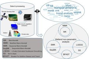
Coastal wetlands offer essential ecosystem services, but are increasingly threatened by anthropogenic activities and climate change. These disrupt regional patterns, necessitating time series analyses to inform their long-term trends. Remote sensing provides cost-effective alternatives to demanding traditional wetland monitoring. Here, we employed a 40-year time series of Landsat data, supplemented by Sentinel-1 SAR imagery and Sentinel-2 multispectral data for enhanced recent-period analysis, and applied non-parametric trend analysis to examine changes in water bodies, vegetation, and climatic conditions in Miankaleh peninsula, encompassing an extensive Ramsar site in Iran. We utilized spectral indices and random forest classification to derive the area of water bodies and vegetation, followed by identifying significant trends using various trend analysis methods: Mann-Kendall (MK), Modified Mann-Kendall (MMK), Sequential Mann-Kendall (SeqMK), Seasonal Mann-Kendall (SMK), Sen’s Slope (SS), and LOcally Estimated Scatterplot Smoothing (LOESS). Findings showed a significant reduction in water area (30,700 ha, SS = -1.074) and an increase in vegetation cover (31,400 ha, SS = 1.365) from baseline levels. Among climatic factors, groundwater levels (SS = -0.214) and evaporation (SS = -0.312) were most influential on the wetland. The MMK, accounting for data autocorrelation, provided more accurate results compared to MK, while SeqMK detected important trend change points that were mostly missed by MMK. LOESS visualized local, nonlinear changes and identify subtle trend shifts. The results underscore significant ecological shifts, particularly the reduction of water bodies, which threaten the wetland's functionality. We provide general and case-specific considerations on the sole and complementary application of non-parametric trend analysis approaches, expanding insights into ecological processes in coastal wetlands with broader implications for similar ecosystems.
遥感时间序列揭示的绵卡莱湿地水体与植被40年时空变化趋势
滨海湿地提供了重要的生态系统服务,但受到人为活动和气候变化的威胁日益严重。这些破坏了区域模式,需要时间序列分析来了解其长期趋势。遥感为传统的湿地监测提供了具有成本效益的替代方案。在这里,我们利用40年时间序列的Landsat数据,辅以Sentinel-1 SAR图像和Sentinel-2多光谱数据进行增强的近期分析,并应用非参数趋势分析来研究Miankaleh半岛水体、植被和气候条件的变化,该半岛包括伊朗的一个广泛的拉姆萨尔站点。利用光谱指数和随机森林分类等方法推导水体和植被面积,并利用Mann-Kendall (MK)、Modified Mann-Kendall (MMK)、Sequential Mann-Kendall (SeqMK)、Seasonal Mann-Kendall (SMK)、Sen’s Slope (SS)和local Estimated Scatterplot Smoothing(黄土)等趋势分析方法识别显著趋势。结果显示,与基线水平相比,水域面积显著减少(30,700公顷,SS = -1.074),植被覆盖面积增加(31,400公顷,SS = 1.365)。在气候因子中,地下水水位(SS = -0.214)和蒸发量(SS = -0.312)对湿地的影响最大。与MK相比,MMK考虑了数据的自相关,提供了更准确的结果,而SeqMK检测到了MMK大多错过的重要趋势变化点。黄土可以可视化局部的非线性变化,识别细微的趋势变化。研究结果强调了显著的生态变化,特别是水体的减少,这对湿地的功能构成了威胁。我们对非参数趋势分析方法的单独和补充应用提供了一般和具体的考虑,扩大了对沿海湿地生态过程的见解,并对类似的生态系统具有更广泛的影响。
本文章由计算机程序翻译,如有差异,请以英文原文为准。
求助全文
约1分钟内获得全文
求助全文
来源期刊

Ecological Informatics
环境科学-生态学
CiteScore
8.30
自引率
11.80%
发文量
346
审稿时长
46 days
期刊介绍:
The journal Ecological Informatics is devoted to the publication of high quality, peer-reviewed articles on all aspects of computational ecology, data science and biogeography. The scope of the journal takes into account the data-intensive nature of ecology, the growing capacity of information technology to access, harness and leverage complex data as well as the critical need for informing sustainable management in view of global environmental and climate change.
The nature of the journal is interdisciplinary at the crossover between ecology and informatics. It focuses on novel concepts and techniques for image- and genome-based monitoring and interpretation, sensor- and multimedia-based data acquisition, internet-based data archiving and sharing, data assimilation, modelling and prediction of ecological data.
 求助内容:
求助内容: 应助结果提醒方式:


