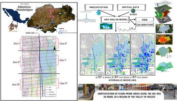
Identification of flood-prone areas using the HEC-RAS 2D model in a region of the Valley of Mexico
IF 8.1
2区 环境科学与生态学
Q1 ENVIRONMENTAL SCIENCES
引用次数: 0
Abstract
This study aims to identify flood-prone areas in the Almoloya-Otzolotepec sub-basin, located in the Valley of Mexico, by applying HEC-RAS 2D model. The region, characterized by a semi-arid climate and variable topography, faces increased flood risks due to accelerated urbanization, which has significantly reduced agricultural land and expanded urban areas. A comprehensive hydrological analysis was conducted, incorporating meteorological data from local stations, IDF curves, and topographic information to develop a Digital Elevation Model (DEM) for simulation purposes. The HEC-RAS 2D model was applied under three different return periods (2, 100, and 500 years) to simulate various flooding scenarios. Results indicated moderate flooding in Zone I during the 2-year return period, with a higher severity observed in Zones II and VI during the 100- and 500-year return periods, where flooding depths could reach up to 5 m. The analysis emphasized the vulnerability of urban areas with insufficient drainage infrastructure, increasing the likelihood of severe flooding in these regions. These findings highlight the critical need for improved flood risk management, including enhanced drainage systems, larger reservoirs, and better urban planning to mitigate the impacts of climate change and protect vulnerable communities. This study provides essential information for designing effective flood mitigation strategies and serves as a basis for future planning and infrastructure improvements in the region to minimize flood damage and enhance resilience to extreme weather events.
在墨西哥河谷地区使用HEC-RAS 2D模型识别洪水易发地区
本研究旨在利用HEC-RAS 2D模型识别位于墨西哥河谷的Almoloya-Otzolotepec子盆地的洪水易发区域。该地区具有半干旱气候和多变地形的特点,由于城市化的加速,农业用地显著减少,城市面积扩大,面临洪水风险增加。我们进行了全面的水文分析,结合当地气象站的气象数据、IDF曲线和地形信息,开发了一个数字高程模型(DEM),用于模拟目的。采用HEC-RAS 2D模型在3个不同的重现期(2100年和500年)下模拟不同的洪水情景。结果表明:1区在2年重现期出现中度洪水,2区和6区在100年和500年重现期出现较严重的洪水,水深可达5 m。该分析强调了排水基础设施不足的城市地区的脆弱性,增加了这些地区发生严重洪水的可能性。这些发现强调了改善洪水风险管理的迫切需要,包括加强排水系统、扩大水库和更好的城市规划,以减轻气候变化的影响并保护脆弱社区。该研究为设计有效的洪水缓解策略提供了必要的信息,并为该地区未来的规划和基础设施改善提供了基础,以最大限度地减少洪水损失,增强对极端天气事件的抵御能力。
本文章由计算机程序翻译,如有差异,请以英文原文为准。
求助全文
约1分钟内获得全文
求助全文
来源期刊
Chemosphere
环境科学-环境科学
CiteScore
15.80
自引率
8.00%
发文量
4975
审稿时长
3.4 months
期刊介绍:
Chemosphere, being an international multidisciplinary journal, is dedicated to publishing original communications and review articles on chemicals in the environment. The scope covers a wide range of topics, including the identification, quantification, behavior, fate, toxicology, treatment, and remediation of chemicals in the bio-, hydro-, litho-, and atmosphere, ensuring the broad dissemination of research in this field.
 求助内容:
求助内容: 应助结果提醒方式:


