Dalei Hao, Gautam Bisht, Lingcheng Li, L. Ruby Leung
{"title":"Representing Fine-Scale Topographic Effects on Surface Radiation Balance in Hyper-Resolution Land Surface Models","authors":"Dalei Hao, Gautam Bisht, Lingcheng Li, L. Ruby Leung","doi":"10.1029/2025MS004987","DOIUrl":null,"url":null,"abstract":"<p>Land surface models are increasingly used to simulate land surface processes at hyper-spatial resolutions (e.g., ∼1 km). As model resolution increases, grid-scale topographic effects on surface radiation fluxes and their interactions between adjacent grids become more pronounced. However, current land surface models routinely neglect the fine-scale topographic effects on surface radiation balance. This study developed physically-based and computationally-efficient parameterizations (fineTOP) that explicitly resolve fine-scale topographic effects on downward shortwave and longwave radiation as well as land surface radiative properties. The newly developed parameterizations were implemented and tested in the Energy Exascale Earth System Model (E3SM) Land Model (ELM). Multi-decadal km-resolution ELM simulations over the California Sierra Nevada show that fine-scale topography significantly impacts the surface energy balance and snow processes across seasons. Slope determines the magnitude of topographic effects, while aspect controls their sign. For slopes larger than 30°, topography-induced change in annual surface temperature can be as large as 3.3 K. Regionally, the mean value and standard deviation of topography-induced changes in annual surface temperature are −0.22 ± 0.38 K and +0.25 ± 0.37 K over north-facing and south-facing slopes, respectively. Topography-induced changes in surface radiative properties account for 3.5% ± 13.8% of total topographic effects on annual net radiation. With fineTOP, ELM captures the aspect-dependence of snow cover fraction, snow water equivalent, and land surface temperature found in MODIS satellite observations and a snow reanalysis data set, while the default ELM fails to capture this phenomenon. The enhanced capability to represent fine-scale topographic effects on surface radiation balance can be used to advance understanding of the role of fine-scale topography in land surface processes and land-atmosphere interactions over mountainous regions.</p>","PeriodicalId":14881,"journal":{"name":"Journal of Advances in Modeling Earth Systems","volume":"17 8","pages":""},"PeriodicalIF":4.6000,"publicationDate":"2025-08-03","publicationTypes":"Journal Article","fieldsOfStudy":null,"isOpenAccess":false,"openAccessPdf":"https://onlinelibrary.wiley.com/doi/epdf/10.1029/2025MS004987","citationCount":"0","resultStr":null,"platform":"Semanticscholar","paperid":null,"PeriodicalName":"Journal of Advances in Modeling Earth Systems","FirstCategoryId":"89","ListUrlMain":"https://agupubs.onlinelibrary.wiley.com/doi/10.1029/2025MS004987","RegionNum":2,"RegionCategory":"地球科学","ArticlePicture":[],"TitleCN":null,"AbstractTextCN":null,"PMCID":null,"EPubDate":"","PubModel":"","JCR":"Q1","JCRName":"METEOROLOGY & ATMOSPHERIC SCIENCES","Score":null,"Total":0}
引用次数: 0
Abstract
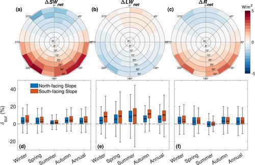
Land surface models are increasingly used to simulate land surface processes at hyper-spatial resolutions (e.g., ∼1 km). As model resolution increases, grid-scale topographic effects on surface radiation fluxes and their interactions between adjacent grids become more pronounced. However, current land surface models routinely neglect the fine-scale topographic effects on surface radiation balance. This study developed physically-based and computationally-efficient parameterizations (fineTOP) that explicitly resolve fine-scale topographic effects on downward shortwave and longwave radiation as well as land surface radiative properties. The newly developed parameterizations were implemented and tested in the Energy Exascale Earth System Model (E3SM) Land Model (ELM). Multi-decadal km-resolution ELM simulations over the California Sierra Nevada show that fine-scale topography significantly impacts the surface energy balance and snow processes across seasons. Slope determines the magnitude of topographic effects, while aspect controls their sign. For slopes larger than 30°, topography-induced change in annual surface temperature can be as large as 3.3 K. Regionally, the mean value and standard deviation of topography-induced changes in annual surface temperature are −0.22 ± 0.38 K and +0.25 ± 0.37 K over north-facing and south-facing slopes, respectively. Topography-induced changes in surface radiative properties account for 3.5% ± 13.8% of total topographic effects on annual net radiation. With fineTOP, ELM captures the aspect-dependence of snow cover fraction, snow water equivalent, and land surface temperature found in MODIS satellite observations and a snow reanalysis data set, while the default ELM fails to capture this phenomenon. The enhanced capability to represent fine-scale topographic effects on surface radiation balance can be used to advance understanding of the role of fine-scale topography in land surface processes and land-atmosphere interactions over mountainous regions.
期刊介绍:
The Journal of Advances in Modeling Earth Systems (JAMES) is committed to advancing the science of Earth systems modeling by offering high-quality scientific research through online availability and open access licensing. JAMES invites authors and readers from the international Earth systems modeling community.
Open access. Articles are available free of charge for everyone with Internet access to view and download.
Formal peer review.
Supplemental material, such as code samples, images, and visualizations, is published at no additional charge.
No additional charge for color figures.
Modest page charges to cover production costs.
Articles published in high-quality full text PDF, HTML, and XML.
Internal and external reference linking, DOI registration, and forward linking via CrossRef.


 求助内容:
求助内容: 应助结果提醒方式:


