Emergent archetype patterns of coupled land use/land cover and hydrogeologic responses on a regional scale
IF 5.7
1区 农林科学
Q1 GEOSCIENCES, MULTIDISCIPLINARY
引用次数: 0
Abstract
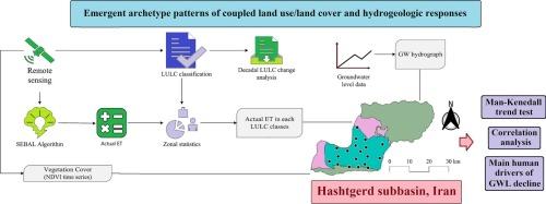
This study integrates remote sensing, statistical methods, and system dynamics archetypes to analyze the spatiotemporal interplay between land use/land cover (LULC) changes, groundwater levels (GWL), and actual evapotranspiration (ETA) in Iran’s semi-arid Hashtgerd subbasin (2000–2019). While existing studies predominantly employ model-driven approaches (e.g., SWAT and MODFLOW) to assess LULC impacts on groundwater, this work has pioneered the use of system dynamics archetypes—a novel framework—to diagnose self-reinforcing feedback mechanisms (e.g., ’limits to growth’) that perpetuate depletion, offering a scalable paradigm for semi-arid regions. Multi-sensor satellite data (Landsat, Sentinel-2, WorldView-3), digital elevation models, and groundwater observations were used to map annual LULC dynamics and quantify ETA via a SEBAL model. The findings reveal accelerated groundwater depletion, projecting a 32-meter decline by 2050, driven primarily by urbanization and agricultural intensification. A 4 % reduction in bare land and irrigated cropland—converted predominantly to residential and garden areas—correlated with increased ETA (residential: Zmk = 6.54; gardens: Zsmk = 2.68) and diminished aquifer recharge. Mann-Kendall and Pettitt tests revealed a critical hydrological shift after 2010, marked by intensified GWL depletions (−0.12 m/month). The archetypal analysis highlighted systemic feedback mechanisms, notably the “limits to growth” pattern, wherein unchecked LULC transitions exacerbate groundwater scarcity through self-reinforcing cycles of demand and depletion. Lagged Pearson correlations further linked residential expansion to GWL reductions (r = − 0.40 at 5-month lag). The results underscore anthropogenic drivers as dominant contributors to groundwater stress, advocating policy measures that align urban growth with aquifer sustainability. By bridging geospatial analytics with system dynamics, this study offers a scalable framework for addressing water-security challenges in semi-arid regions under socio-environmental pressures.
区域尺度上土地利用/土地覆盖与水文地质响应耦合的涌现原型模式
本研究结合遥感、统计方法和系统动力学原型,分析了2000-2019年伊朗半干旱哈什格德次流域土地利用/土地覆盖(LULC)变化、地下水位(GWL)和实际蒸散(ETA)之间的时空相互作用。虽然现有的研究主要采用模型驱动的方法(如SWAT和MODFLOW)来评估LULC对地下水的影响,但这项工作开创了使用系统动力学原型(一种新的框架)来诊断使枯竭永续的自我强化反馈机制(如“增长极限”)的先河,为半干旱地区提供了可扩展的范例。多传感器卫星数据(Landsat、Sentinel-2、WorldView-3)、数字高程模型和地下水观测数据用于绘制年度LULC动态图,并通过SEBAL模型量化ETA。研究结果显示,地下水枯竭加速,预计到2050年将下降32米,主要受城市化和农业集约化的推动。裸地和灌溉农田减少4%,主要转化为住宅和花园区域,与ETA增加相关(住宅:Zmk = 6.54;花园:Zsmk = 2.68)和含水层补给减少。Mann-Kendall和Pettitt试验揭示了2010年后的关键水文转变,其特征是GWL消耗加剧(- 0.12 m/月)。原型分析强调了系统反馈机制,特别是“增长极限”模式,其中不受控制的LULC过渡通过需求和枯竭的自我强化循环加剧了地下水短缺。滞后Pearson相关性进一步将住宅扩张与GWL减少联系起来(滞后5个月时r = - 0.40)。研究结果强调,人为因素是造成地下水压力的主要因素,并主张采取政策措施,使城市增长与含水层的可持续性保持一致。通过将地理空间分析与系统动力学相结合,本研究为解决社会环境压力下半干旱地区的水安全挑战提供了一个可扩展的框架。
本文章由计算机程序翻译,如有差异,请以英文原文为准。
求助全文
约1分钟内获得全文
求助全文
来源期刊

Catena
环境科学-地球科学综合
CiteScore
10.50
自引率
9.70%
发文量
816
审稿时长
54 days
期刊介绍:
Catena publishes papers describing original field and laboratory investigations and reviews on geoecology and landscape evolution with emphasis on interdisciplinary aspects of soil science, hydrology and geomorphology. It aims to disseminate new knowledge and foster better understanding of the physical environment, of evolutionary sequences that have resulted in past and current landscapes, and of the natural processes that are likely to determine the fate of our terrestrial environment.
Papers within any one of the above topics are welcome provided they are of sufficiently wide interest and relevance.
 求助内容:
求助内容: 应助结果提醒方式:


