Sampling design for binary geostatistical data, application to inspection actions of fishing activity in Portugal
IF 2.5
2区 数学
Q3 GEOSCIENCES, MULTIDISCIPLINARY
引用次数: 0
Abstract
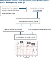
The definition of surveillance routes is a very important but complex issue. The Portuguese Navy, in its common form of operation is in charge of the Naval Standard Device, which is distributed throughout the various coastal areas of the country. Enforcement actions can involve very high costs, so a good plan for the sampling designs used are in order, as to maximize the efficiency in obtaining information from the data of the actions developed over the area under consideration. The main objective of this study is to propose sampling design criteria based on geostatistical models, in the context of binary data on presumed maritime infractions in the Portuguese coast, that are advantageous in the optimization of maritime surveillance actions, in terms of efforts employed in their execution, in the maritime area of Portugal’s responsibility. Two sampling design selection criteria are proposed: Maximum Risk Sampling design and Maximum Variance Risk Sampling Design. These are compared to the simple random design by the root mean square error (RMSE). A comparison of the designs at different sample sizes is made and the estimated risk maximization sampling design presents the best RMSE value. The proposed sampling designs may assist in the creation of alternative enforcement Portuguese Navy routes, optimizing the scheduling that maximizes the probability of finding a higher number of presumed fishing perpetrators with less resource efforts.
二元地质统计数据的抽样设计,在葡萄牙渔业活动检查行动中的应用
监测路线的确定是一个非常重要而又复杂的问题。葡萄牙海军在其共同的行动形式中负责海军标准装置,该装置分布在该国各个沿海地区。执法行动可能涉及非常高的成本,因此,为所使用的抽样设计制定一个良好的计划是有必要的,以便最大限度地从所考虑的地区开展的行动的数据中获得信息。本研究的主要目的是提出基于地质统计模型的抽样设计标准,在葡萄牙海岸推定的海事违规行为的二进制数据的背景下,这有利于在葡萄牙负责的海事区域内优化海事监视行动,就其执行所采取的努力而言。提出了两种抽样设计选择准则:最大风险抽样设计和最大方差风险抽样设计。通过均方根误差(RMSE)将这些与简单随机设计进行比较。对不同样本量下的设计进行了比较,发现风险最大化的估计样本量设计呈现出最佳的RMSE值。建议的抽样设计可能有助于创建葡萄牙海军的替代执法路线,优化调度,最大限度地利用较少的资源努力找到更多的推定捕鱼肇事者。
本文章由计算机程序翻译,如有差异,请以英文原文为准。
求助全文
约1分钟内获得全文
求助全文
来源期刊
Spatial Statistics
GEOSCIENCES, MULTIDISCIPLINARY-MATHEMATICS, INTERDISCIPLINARY APPLICATIONS
CiteScore
4.00
自引率
21.70%
发文量
89
审稿时长
55 days
期刊介绍:
Spatial Statistics publishes articles on the theory and application of spatial and spatio-temporal statistics. It favours manuscripts that present theory generated by new applications, or in which new theory is applied to an important practical case. A purely theoretical study will only rarely be accepted. Pure case studies without methodological development are not acceptable for publication.
Spatial statistics concerns the quantitative analysis of spatial and spatio-temporal data, including their statistical dependencies, accuracy and uncertainties. Methodology for spatial statistics is typically found in probability theory, stochastic modelling and mathematical statistics as well as in information science. Spatial statistics is used in mapping, assessing spatial data quality, sampling design optimisation, modelling of dependence structures, and drawing of valid inference from a limited set of spatio-temporal data.
 求助内容:
求助内容: 应助结果提醒方式:


