Integration of TDEM and HVSR surveys for water resources investigation in arid regions: The case of Horombe plateau, Madagascar
IF 2.1
3区 地球科学
Q2 GEOSCIENCES, MULTIDISCIPLINARY
引用次数: 0
Abstract
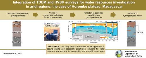
The increasing threat of droughts, due to climate variability and rising water demands, is further exacerbated by the lack of hydrogeological knowledge of remote areas such as Southern Madagascar. This study aims to showcase the utility of cost-effective and portable geophysical methods alongside with detailed geological and hydrogeological investigations to enhance water resource exploration in arid regions.
For this purpose, integration of Horizontal-to-Vertical Spectral Ratio (HVSR) and Time Domain Electromagnetic Method (TDEM) has been adopted to investigate a 5 km2 area, with 41 survey points, in a zone of the Horombe plateau, in South Madagascar, remote and mostly unknown from the geological point of view.
Considering the dominant frequencies of HVSR, the TDEM resistivity model and the few available literature and field geological data (a water well sampling campaign), a geological interpretation of geophysical data was performed to assess the distribution and extent of water resources. The proposed geological/hydrogeological interpretation consists of a laterite cover, hosting irregular and ephemeral aquifers, a saprolite layer, hosting the main aquifer, and a gneiss bedrock.
According to the results of this study, three new water wells were drilled where geophysical data detected the thickest aquifer. The wells validated the proposed geological model and confirmed the presence of main aquifers in the bottom part of saprolite layer and thinner aquifers in the lateritic cover.
The results of the study offer a framework for the application of easy-to-operate geophysical solutions for water resources management in remote arid areas with scarcity of available data. The paper also discusses the limitations and uncertainties in geophysical data interpretation, particularly regarding the achievable investigation depth.
干旱区水资源调查中TDEM与HVSR的结合:以马达加斯加Horombe高原为例
由于气候变化和不断上升的水需求,干旱的威胁日益增加,而马达加斯加南部等偏远地区缺乏水文地质知识,进一步加剧了干旱的威胁。本研究旨在展示具有成本效益和便携的地球物理方法与详细的地质和水文地质调查的效用,以加强干旱区水资源勘探。为此,采用水平-垂直光谱比(HVSR)和时域电磁法(TDEM)相结合的方法,在马达加斯加南部Horombe高原的一个区域进行了5平方公里的41个测点的调查,从地质角度来看,该区域偏远且几乎未知。考虑到HVSR的主导频率、TDEM电阻率模型以及少量可用的文献和现场地质数据(水井采样活动),对地球物理数据进行了地质解释,以评估水资源的分布和范围。提出的地质/水文地质解释包括红土覆盖层(含不规则和短暂的含水层)、腐岩层(含主要含水层)和片麻质基岩。根据这项研究的结果,在地球物理数据检测到最厚的含水层的地方钻了三个新水井。井对地质模型进行了验证,确认了腐岩层底部存在主含水层,红土覆盖层中存在较薄含水层。该研究结果为易于操作的地球物理解决方案在偏远干旱地区可用数据稀缺的水资源管理中的应用提供了一个框架。本文还讨论了地球物理资料解释的局限性和不确定性,特别是在可实现的调查深度方面。
本文章由计算机程序翻译,如有差异,请以英文原文为准。
求助全文
约1分钟内获得全文
求助全文
来源期刊

Journal of Applied Geophysics
地学-地球科学综合
CiteScore
3.60
自引率
10.00%
发文量
274
审稿时长
4 months
期刊介绍:
The Journal of Applied Geophysics with its key objective of responding to pertinent and timely needs, places particular emphasis on methodological developments and innovative applications of geophysical techniques for addressing environmental, engineering, and hydrological problems. Related topical research in exploration geophysics and in soil and rock physics is also covered by the Journal of Applied Geophysics.
 求助内容:
求助内容: 应助结果提醒方式:


