Y. Yoshizumi, Y. Yokota, M. Kaneda, S. Yamaura, Y. Kameta, T. Inoue, K. Kouno
{"title":"Construction and Demonstration of a Seaplane-Type UAV-Based High-Precision GNSS-A Seafloor Crustal Deformation Observation System","authors":"Y. Yoshizumi, Y. Yokota, M. Kaneda, S. Yamaura, Y. Kameta, T. Inoue, K. Kouno","doi":"10.1029/2025EA004237","DOIUrl":null,"url":null,"abstract":"<p>The Global Navigation Satellite System—Acoustic combination (GNSS-A) is used to observe seafloor crustal deformation by determining the global position of the seafloor with GNSS positioning and acoustic ranging between a sea surface platform and a transponder station located on the seafloor. However, GNSS-A observations are currently conducted mainly by vessels, and economic and physical constraints limit the ability to improve the frequency and real-time nature of observations. Therefore, unmanned arial vehicle (UAV) -based GNSS-A observation has been proposed. In this study, we constructed a GNSS-A system based on a seaplane-type UAV capable of centimeter-level measurements and evaluated its seafloor positioning performance. An experiment in a tank showed that the system has an acoustic ranging accuracy of less than 2.1 cm, and allowed us to evaluate the previously unreported fractional wavelength instrumental biases. UAV-based GNSS-A tests were conducted using the constructed system at an actual GNSS-A site. Under optimal sea conditions devoid of significant waves or wind, the observation result suggested that seafloor positioning could be achieved with a horizontal RMS of approximately 1–2 cm—comparable to that of vessel-based systems. Thus, we established the foundations for practical UAV observation technology for the operation of high-frequency observations and emergency observations for detecting postseismic deformation. It has also become possible to verify instrument bias in a vessel-based system.</p>","PeriodicalId":54286,"journal":{"name":"Earth and Space Science","volume":"12 7","pages":""},"PeriodicalIF":2.6000,"publicationDate":"2025-07-23","publicationTypes":"Journal Article","fieldsOfStudy":null,"isOpenAccess":false,"openAccessPdf":"https://onlinelibrary.wiley.com/doi/epdf/10.1029/2025EA004237","citationCount":"0","resultStr":null,"platform":"Semanticscholar","paperid":null,"PeriodicalName":"Earth and Space Science","FirstCategoryId":"89","ListUrlMain":"https://agupubs.onlinelibrary.wiley.com/doi/10.1029/2025EA004237","RegionNum":3,"RegionCategory":"地球科学","ArticlePicture":[],"TitleCN":null,"AbstractTextCN":null,"PMCID":null,"EPubDate":"","PubModel":"","JCR":"Q2","JCRName":"ASTRONOMY & ASTROPHYSICS","Score":null,"Total":0}
引用次数: 0
Abstract
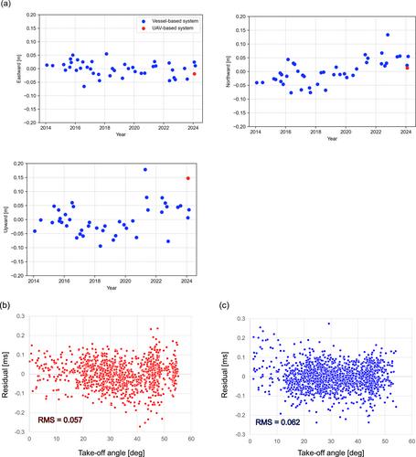
The Global Navigation Satellite System—Acoustic combination (GNSS-A) is used to observe seafloor crustal deformation by determining the global position of the seafloor with GNSS positioning and acoustic ranging between a sea surface platform and a transponder station located on the seafloor. However, GNSS-A observations are currently conducted mainly by vessels, and economic and physical constraints limit the ability to improve the frequency and real-time nature of observations. Therefore, unmanned arial vehicle (UAV) -based GNSS-A observation has been proposed. In this study, we constructed a GNSS-A system based on a seaplane-type UAV capable of centimeter-level measurements and evaluated its seafloor positioning performance. An experiment in a tank showed that the system has an acoustic ranging accuracy of less than 2.1 cm, and allowed us to evaluate the previously unreported fractional wavelength instrumental biases. UAV-based GNSS-A tests were conducted using the constructed system at an actual GNSS-A site. Under optimal sea conditions devoid of significant waves or wind, the observation result suggested that seafloor positioning could be achieved with a horizontal RMS of approximately 1–2 cm—comparable to that of vessel-based systems. Thus, we established the foundations for practical UAV observation technology for the operation of high-frequency observations and emergency observations for detecting postseismic deformation. It has also become possible to verify instrument bias in a vessel-based system.
期刊介绍:
Marking AGU’s second new open access journal in the last 12 months, Earth and Space Science is the only journal that reflects the expansive range of science represented by AGU’s 62,000 members, including all of the Earth, planetary, and space sciences, and related fields in environmental science, geoengineering, space engineering, and biogeochemistry.


 求助内容:
求助内容: 应助结果提醒方式:


