Urban flood modeling using hydrograph and Rain-on-Grid approaches with HEC-HMS and HEC-RAS: A case study of the Culiacán River
IF 1.5
4区 地球科学
Q3 GEOSCIENCES, MULTIDISCIPLINARY
引用次数: 0
Abstract
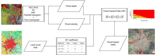
Floods are devastating natural disasters, causing extensive economic losses and fatalities globally each year. In developing regions, flood modeling is often hindered by limited or inconsistent hydrometeorological data and historical records. Accurate floodplain modeling is essential for assessing flood risks and identifying vulnerable areas. Combining hydrological and hydraulic models with GIS has become a key approach for simulating and analyzing flood events, particularly in ungauged watersheds. Traditionally, flood simulation is a two-step process where a hydrological model provides flow input for a separate hydraulic model. Modern approaches, such as 'Rain-on-Grid', use a single and integrated step: rainfall is applied directly to a 2D hydraulic model's grid, which handles both runoff generation and the routing of water through the landscape, channels, and streets. This study models urban flooding by integrating a 'Rain-on-Grid' approach for surface runoff with a hydrograph, derived from SCS and Snyder methods, to simulate the river flow. Model performance was assessed against gauging station data. For the SCS model, results showed R2 values of 0.927, NSE of 0.678, RMSE of 2.1, and PBIAS of 12.06 for the SCS model; the Snyder model presented an R2 of 0.865, NSE of 0.75, RMSE equal to 2.3, and PBIAS of 23.84, indicating comparable performance. Hydraulic simulation was evaluated using the fraction of model performance (F(2)), with values of 0.7101 (SCS) and 0.7108 (Snyder). Hazard mapping identified rivers, irrigation canals, drains, levees, and road crossings as high-risk zones. Additionally, intermittent streams present significant flood hazards due to rapid onset and high flow velocities, posing threats to vehicles and residents.
基于HEC-HMS和HEC-RAS的水文图和网格降雨方法的城市洪水建模:以Culiacán河为例
洪水是毁灭性的自然灾害,每年在全球造成广泛的经济损失和人员伤亡。在发展中地区,洪水模型经常受到有限或不一致的水文气象数据和历史记录的阻碍。准确的洪泛区建模对于评估洪水风险和确定易损区域至关重要。将水文和水力模型与GIS相结合已成为模拟和分析洪水事件的关键方法,特别是在未测量的流域。传统上,洪水模拟是一个两步过程,其中水文模型为单独的水力模型提供流量输入。现代方法,如“网格降雨”,使用单一和集成的步骤:降雨直接应用于2D水力模型的网格,该网格处理径流产生和水通过景观,渠道和街道的路径。本研究通过将“网格降雨”方法与来自SCS和Snyder方法的水文图相结合来模拟河流流量,从而模拟城市洪水。模型的性能是根据测量站的数据进行评估的。SCS模型的R2值为0.927,NSE为0.678,RMSE为2.1,PBIAS为12.06;Snyder模型的R2为0.865,NSE为0.75,RMSE为2.3,PBIAS为23.84,具有可比性。水力模拟使用模型性能分数(F(2))进行评估,其值为0.7101 (SCS)和0.7108 (Snyder)。危险地图将河流、灌溉渠、排水沟、堤坝和十字路口确定为高风险区域。此外,间歇性河流因其快速发作和高流速而构成严重的洪水危险,对车辆和居民构成威胁。
本文章由计算机程序翻译,如有差异,请以英文原文为准。
求助全文
约1分钟内获得全文
求助全文
来源期刊

Journal of South American Earth Sciences
地学-地球科学综合
CiteScore
3.70
自引率
22.20%
发文量
364
审稿时长
6-12 weeks
期刊介绍:
Papers must have a regional appeal and should present work of more than local significance. Research papers dealing with the regional geology of South American cratons and mobile belts, within the following research fields:
-Economic geology, metallogenesis and hydrocarbon genesis and reservoirs.
-Geophysics, geochemistry, volcanology, igneous and metamorphic petrology.
-Tectonics, neo- and seismotectonics and geodynamic modeling.
-Geomorphology, geological hazards, environmental geology, climate change in America and Antarctica, and soil research.
-Stratigraphy, sedimentology, structure and basin evolution.
-Paleontology, paleoecology, paleoclimatology and Quaternary geology.
New developments in already established regional projects and new initiatives dealing with the geology of the continent will be summarized and presented on a regular basis. Short notes, discussions, book reviews and conference and workshop reports will also be included when relevant.
 求助内容:
求助内容: 应助结果提醒方式:


