Vertical planning and optimization strategies of green measures in urban flood control: combining automated land use segmentation with integrated hydrodynamic calculations
IF 12.4
1区 环境科学与生态学
Q1 ENGINEERING, ENVIRONMENTAL
引用次数: 0
Abstract
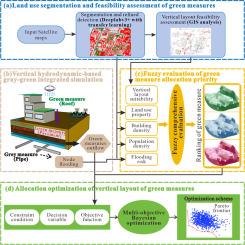
Urban land available for flood management, particularly for the allocation of green measures, is becoming increasingly scarce, especially in many developing cities undergoing rapid urbanization. Currently, methods guiding the allocation of green measures mainly focus on planar planning, and there is a lack of framework to optimize the allocation of green measures by integrating both planar and vertical planning perspectives, so as to comprehensively evaluate the feasibility of allocation, flood control performance, and economic factors. In this paper, an optimization framework for vertical collaborative allocation of green measures based on automated land use segmentation and gray-green coupled hydrodynamic calculation is proposed. The framework comprised four interrelated modules: (1) Automated land use segmentation based on Deeplabv3+ and transfer learning, and feasibility assessment of vertical layout of green measures, which were used to detect the distribution and area of urban land use and quantify the feasibility of green measures from both planar and vertical perspectives. (2) Vertical hydrodynamic-based gray-green system simulation, to realize runoff transfer and interactive calculations between multi-layered vertical green measures, as well as between these measures and the underground drainage network. (3) Establishment of a fuzzy priority evaluation model to evaluate and rank the priority of different green measures from multiple dimensions, such as flood risk and allocation feasibility. (4) The spatial allocation of green measures based on multi-objective Bayesian optimization, and the Pareto frontiers under different schemes were solved according to the results from the previous modules. Results indicated that a well-planned vertical allocation of green measures could significantly reduce the runoff discharge (by 13.97 % to 100 %) and delay the peak discharge time in the case study. The optimized green layout scheme effectively mitigated flooding in 92.55 % of the subcatchments, highlighting the importance of vertical layout optimization of urban green measures.

城市防洪绿色措施纵向规划与优化策略:结合自动化土地利用分割与综合水动力计算
可用于洪水管理的城市土地,特别是用于分配绿色措施的城市土地越来越少,特别是在许多正在快速城市化的发展中城市。目前,指导绿色措施配置的方法主要集中在平面规划上,缺乏从平面规划和垂直规划两个角度对绿色措施配置进行优化的框架,从而对配置的可行性、防洪效果和经济因素进行综合评价。本文提出了一种基于土地利用自动分割和灰绿耦合水动力计算的绿色措施垂直协同配置优化框架。该框架包括四个相互关联的模块:(1)基于Deeplabv3+和迁移学习的土地利用自动分割和绿色措施垂直布局可行性评估,从平面和垂直两个角度检测城市土地利用的分布和面积,量化绿色措施的可行性。(2)基于垂直水动力学的灰绿系统模拟,实现多层垂直绿化措施之间以及这些措施与地下排水网络之间的径流转移和交互计算。(3)建立模糊优先级评价模型,从洪水风险、配置可行性等多个维度对不同绿色措施的优先级进行评价和排序。(4)基于多目标贝叶斯优化,求解不同方案下的绿色措施空间配置和Pareto边界。结果表明,规划合理的绿色措施垂直配置可以显著减少径流流量(13.97% ~ 100%),并延迟峰值排放时间。优化后的绿色布局方案有效缓解了92.55%的子集水区的洪水,突出了城市绿色措施垂直布局优化的重要性。
本文章由计算机程序翻译,如有差异,请以英文原文为准。
求助全文
约1分钟内获得全文
求助全文
来源期刊
Water Research
环境科学-工程:环境
CiteScore
20.80
自引率
9.40%
发文量
1307
审稿时长
38 days
期刊介绍:
Water Research, along with its open access companion journal Water Research X, serves as a platform for publishing original research papers covering various aspects of the science and technology related to the anthropogenic water cycle, water quality, and its management worldwide. The audience targeted by the journal comprises biologists, chemical engineers, chemists, civil engineers, environmental engineers, limnologists, and microbiologists. The scope of the journal include:
•Treatment processes for water and wastewaters (municipal, agricultural, industrial, and on-site treatment), including resource recovery and residuals management;
•Urban hydrology including sewer systems, stormwater management, and green infrastructure;
•Drinking water treatment and distribution;
•Potable and non-potable water reuse;
•Sanitation, public health, and risk assessment;
•Anaerobic digestion, solid and hazardous waste management, including source characterization and the effects and control of leachates and gaseous emissions;
•Contaminants (chemical, microbial, anthropogenic particles such as nanoparticles or microplastics) and related water quality sensing, monitoring, fate, and assessment;
•Anthropogenic impacts on inland, tidal, coastal and urban waters, focusing on surface and ground waters, and point and non-point sources of pollution;
•Environmental restoration, linked to surface water, groundwater and groundwater remediation;
•Analysis of the interfaces between sediments and water, and between water and atmosphere, focusing specifically on anthropogenic impacts;
•Mathematical modelling, systems analysis, machine learning, and beneficial use of big data related to the anthropogenic water cycle;
•Socio-economic, policy, and regulations studies.
 求助内容:
求助内容: 应助结果提醒方式:


