Mapping and understanding the regional farmland SOC distribution in southern China using a Bayesian spatial model
IF 6.6
1区 农林科学
Q1 SOIL SCIENCE
引用次数: 0
Abstract
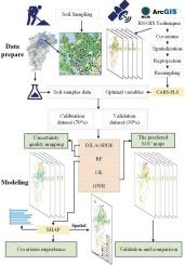
Information on the spatial distribution of soil organic carbon (SOC) in regional farmland is crucial for improving management and production. Mapping SOC in farmlands is challenging due to the strong variation of SOC caused by the influence of natural and anthropogenic activities. Additionally, currently widely used predictive models usually suffer from a lack of model interpretability. To fill these gaps, here we use a Bayesian spatial model termed Integrated Nested Laplace Approximation with the Stochastic Partial Differential Equation (INLA-SPDE) to produce the fine scale SOC map in the farmland of Jiangxi Province, south China based on an extensive soil survey dataset (n = 16,050). The competitive adaptive reweighted sampling algorithm − partial least square (CARS-PLS) algorithm is adopted to select the most related covariates from the original covariates pool. Then, the performance of Random Forest (RF), Geographically Weighted Regression (GWR), and Ordinary Kriging (OK) was compared with INLA-SPDE. Finally, an interpretable machine learning model, the SHapley Additive exPlanation (SHAP), is used to quantify the environmental covariates’ contribution to mapping SOC, as well as mapping spatial varying primary covariates for predicting SOC in the study area. We find that INLA-SPDE was able to handle a large data and performed much better than OK and GWR with an improvement of 38.89 % and 117.39 % in R2, respectively. It also outperforms RF. Overall, amount of straw return, mean annual precipitation, mean annual solar radiation are the most important covariates for mapping SOC. Locally, soil management are the most important covariates for mapping SOC in 50.52 % regions of the study area, followed by climate factors (22.06 %), soil properties (17.09 %), terrain (6.38 %), lithology (2.21 %) and biota factors (1.72 %). Our study demonstrates the advantages of INLA-SPDE on mapping SOC compared with geostatistical and RF for SOC mapping and provides valuable implications for interpreting the results of digital soil mapping.
基于贝叶斯空间模型的中国南方农田有机碳区域分布
区域农田土壤有机碳(SOC)空间分布信息对改善经营和生产具有重要意义。由于受自然和人为活动的影响,农田土壤有机碳的变化很大,因此对农田土壤有机碳的绘制具有挑战性。此外,目前广泛使用的预测模型通常存在模型可解释性不足的问题。为了填补这些空白,本文基于广泛的土壤调查数据集(n = 16,050),采用基于随机偏微分方程的集成嵌套拉普拉斯近似贝叶斯空间模型(INLA-SPDE)生成了中国南方江西省农田土壤有机碳精细比例图。采用竞争自适应重加权抽样算法-偏最小二乘(CARS-PLS)算法从原始协变量池中选择相关度最高的协变量。然后,将随机森林(RF)、地理加权回归(GWR)和普通克里格(OK)的性能与INLA-SPDE进行比较。最后,使用可解释的机器学习模型SHapley加性解释(SHAP)来量化环境协变量对土壤有机碳映射的贡献,以及映射空间变化的主协变量来预测研究区域的土壤有机碳。我们发现INLA-SPDE能够处理大数据,并且表现比OK和GWR好得多,在R2中分别提高38.89%和117.39%。它也优于射频。总体而言,秸秆还田量、年平均降水量、年平均太阳辐射是土壤有机碳映射最重要的协变量。在局域范围内,土壤管理是影响土壤有机碳含量的最重要协变量,其次是气候因子(22.06%)、土壤性质(17.09%)、地形(6.38%)、岩性(2.21%)和生物群因子(1.72%)。本研究证明了INLA-SPDE在土壤有机碳制图方面的优势,并为数字土壤制图结果的解释提供了有价值的启示。
本文章由计算机程序翻译,如有差异,请以英文原文为准。
求助全文
约1分钟内获得全文
求助全文
来源期刊

Geoderma
农林科学-土壤科学
CiteScore
11.80
自引率
6.60%
发文量
597
审稿时长
58 days
期刊介绍:
Geoderma - the global journal of soil science - welcomes authors, readers and soil research from all parts of the world, encourages worldwide soil studies, and embraces all aspects of soil science and its associated pedagogy. The journal particularly welcomes interdisciplinary work focusing on dynamic soil processes and functions across space and time.
 求助内容:
求助内容: 应助结果提醒方式:


