Scientific response to the 2024-2025 dyke intrusions in the Fentale-Dofen Region, Ethiopia: geophysical monitoring, surface manifestations, and hazard mapping.
Elias Lewi, Juliet Biggs, Atalay Ayele, Tim Wright, Carolina Pagli, Derek Keir, Yechale Ali, Genet Assefa, Hua Wang, Alessandro La Rosa, Lin Way, Filagot Mengistu, Susan Loughlin, Raphaël Grandin, Tesfaye Temtime, Yelebe Birhanu, Jeffrey Freymueller, Weiyu Zheng
{"title":"Scientific response to the 2024-2025 dyke intrusions in the Fentale-Dofen Region, Ethiopia: geophysical monitoring, surface manifestations, and hazard mapping.","authors":"Elias Lewi, Juliet Biggs, Atalay Ayele, Tim Wright, Carolina Pagli, Derek Keir, Yechale Ali, Genet Assefa, Hua Wang, Alessandro La Rosa, Lin Way, Filagot Mengistu, Susan Loughlin, Raphaël Grandin, Tesfaye Temtime, Yelebe Birhanu, Jeffrey Freymueller, Weiyu Zheng","doi":"10.1007/s00445-025-01852-x","DOIUrl":null,"url":null,"abstract":"<p><p>In continental rifts, tectonic deformation, magmatic processes, and earthquakes interact dynamically reflecting the crust's complex response to extensional stress and evolving subsurface and surface conditions. Recent seismotectonic activity in the Fentale-Dofen region of the Main Ethiopian Rift was driven by the intrusion of several dykes reaching up to ~ 50 km in length observed using satellite radar interferometry. Over 300 earthquakes with magnitude 4 or greater were reported by international seismic networks and the GNSS site at Addis Ababa moved ~ 20 mm to the west. These and other observations on the ground were used to create a highly simplified hazard map and 75,000 people were evacuated. Although no magmatic eruption occurred, the earthquakes triggered landslides and caused infrastructure damage, especially to buildings and roads. Here we provide a preliminary analysis of the patterns of earthquakes, ground deformation, and surface manifestations from 2024 to 2025, with a focus on the underlying mechanisms contributing to seismic sequences in the area and key unresolved scientific questions. We discuss how scientific evidence was used to inform decision-makers and examine the short- and long-term implications for critical infrastructure and nearby communities. Finally, we emphasize the importance of real-time monitoring, proactive risk management, and the need for continuous observation and improved early warning systems to reduce future seismic and volcanic risks.</p>","PeriodicalId":55297,"journal":{"name":"Bulletin of Volcanology","volume":"87 8","pages":"64"},"PeriodicalIF":3.2000,"publicationDate":"2025-01-01","publicationTypes":"Journal Article","fieldsOfStudy":null,"isOpenAccess":false,"openAccessPdf":"https://www.ncbi.nlm.nih.gov/pmc/articles/PMC12259786/pdf/","citationCount":"0","resultStr":null,"platform":"Semanticscholar","paperid":null,"PeriodicalName":"Bulletin of Volcanology","FirstCategoryId":"89","ListUrlMain":"https://doi.org/10.1007/s00445-025-01852-x","RegionNum":2,"RegionCategory":"地球科学","ArticlePicture":[],"TitleCN":null,"AbstractTextCN":null,"PMCID":null,"EPubDate":"2025/7/14 0:00:00","PubModel":"Epub","JCR":"Q1","JCRName":"GEOSCIENCES, MULTIDISCIPLINARY","Score":null,"Total":0}
引用次数: 0
Abstract
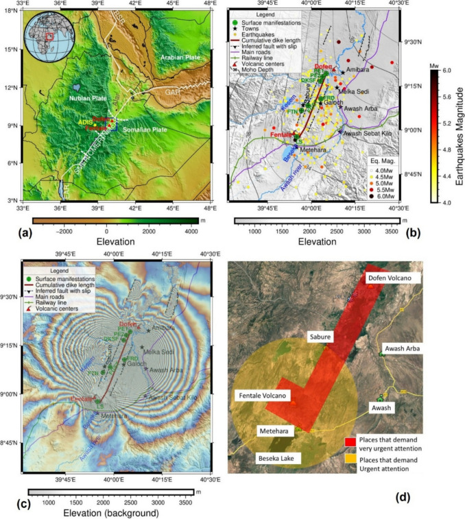
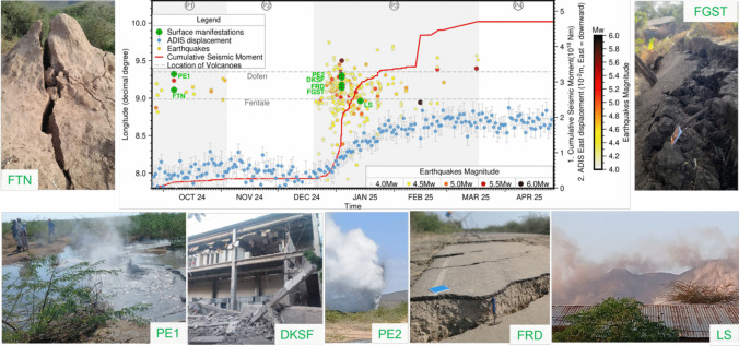
In continental rifts, tectonic deformation, magmatic processes, and earthquakes interact dynamically reflecting the crust's complex response to extensional stress and evolving subsurface and surface conditions. Recent seismotectonic activity in the Fentale-Dofen region of the Main Ethiopian Rift was driven by the intrusion of several dykes reaching up to ~ 50 km in length observed using satellite radar interferometry. Over 300 earthquakes with magnitude 4 or greater were reported by international seismic networks and the GNSS site at Addis Ababa moved ~ 20 mm to the west. These and other observations on the ground were used to create a highly simplified hazard map and 75,000 people were evacuated. Although no magmatic eruption occurred, the earthquakes triggered landslides and caused infrastructure damage, especially to buildings and roads. Here we provide a preliminary analysis of the patterns of earthquakes, ground deformation, and surface manifestations from 2024 to 2025, with a focus on the underlying mechanisms contributing to seismic sequences in the area and key unresolved scientific questions. We discuss how scientific evidence was used to inform decision-makers and examine the short- and long-term implications for critical infrastructure and nearby communities. Finally, we emphasize the importance of real-time monitoring, proactive risk management, and the need for continuous observation and improved early warning systems to reduce future seismic and volcanic risks.
期刊介绍:
Bulletin of Volcanology was founded in 1922, as Bulletin Volcanologique, and is the official journal of the International Association of Volcanology and Chemistry of the Earth’s Interior (IAVCEI). The Bulletin of Volcanology publishes papers on volcanoes, their products, their eruptive behavior, and their hazards. Papers aimed at understanding the deeper structure of volcanoes, and the evolution of magmatic systems using geochemical, petrological, and geophysical techniques are also published. Material is published in four sections: Review Articles; Research Articles; Short Scientific Communications; and a Forum that provides for discussion of controversial issues and for comment and reply on previously published Articles and Communications.
 求助内容:
求助内容: 应助结果提醒方式:


