{"title":"Reconstruction and palaeoclimatic implications of Loch Lomond Readvance glaciers in the Southeast Grampians, Scotland","authors":"William Spicer","doi":"10.1002/jqs.3709","DOIUrl":null,"url":null,"abstract":"<p>The glaciation of Scotland during the Loch Lomond Stadial (LLS; 12.9–11.7 ka BP) left a distinct and well-preserved geomorphological signature, permitting detailed reconstructions of former glaciers and palaeoclimatic conditions. However, the extent and style of glaciation in the Southeast Grampians remains poorly constrained. This study employs geomorphological mapping and glacier surface profile modelling to reconstruct a ∼60 km<sup>2</sup> icefield covering much of the Mounth Plateau. The results suggest that plateau ice was thicker and more extensive than previously considered, with a polythermal regime inferred from the geomorphological evidence. Based on contrasting landform assemblages inside and outside of reconstructed glacial limits and basal radiocarbon dates, the icefield is attributed to the LLS. The geomorphological evidence and superimposed streamlining of recessional moraines within the study site suggest that deglaciation was active and interrupted by periods of re-advance occurring during fluctuating climatic conditions. An equilibrium line altitude of 738 m and a precipitation value at sea level of 845 ± 150 mm a<sup>−1</sup> are calculated for the Mounth Icefield, suggesting a slightly more arid climate than present. Comparison with published glacier-derived palaeoclimatic variables supports a strong west–east precipitation gradient across Scotland during the LLS.</p>","PeriodicalId":16929,"journal":{"name":"Journal of Quaternary Science","volume":"40 5","pages":"747-763"},"PeriodicalIF":2.2000,"publicationDate":"2025-04-03","publicationTypes":"Journal Article","fieldsOfStudy":null,"isOpenAccess":false,"openAccessPdf":"https://onlinelibrary.wiley.com/doi/epdf/10.1002/jqs.3709","citationCount":"0","resultStr":null,"platform":"Semanticscholar","paperid":null,"PeriodicalName":"Journal of Quaternary Science","FirstCategoryId":"89","ListUrlMain":"https://onlinelibrary.wiley.com/doi/10.1002/jqs.3709","RegionNum":3,"RegionCategory":"地球科学","ArticlePicture":[],"TitleCN":null,"AbstractTextCN":null,"PMCID":null,"EPubDate":"","PubModel":"","JCR":"Q3","JCRName":"GEOGRAPHY, PHYSICAL","Score":null,"Total":0}
引用次数: 0
Abstract
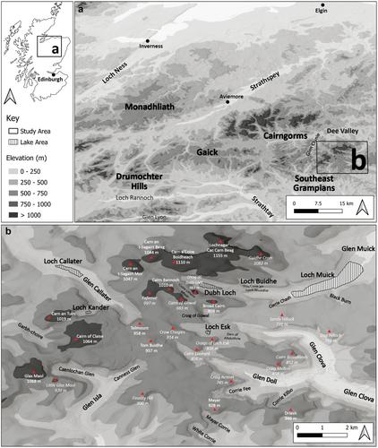
The glaciation of Scotland during the Loch Lomond Stadial (LLS; 12.9–11.7 ka BP) left a distinct and well-preserved geomorphological signature, permitting detailed reconstructions of former glaciers and palaeoclimatic conditions. However, the extent and style of glaciation in the Southeast Grampians remains poorly constrained. This study employs geomorphological mapping and glacier surface profile modelling to reconstruct a ∼60 km2 icefield covering much of the Mounth Plateau. The results suggest that plateau ice was thicker and more extensive than previously considered, with a polythermal regime inferred from the geomorphological evidence. Based on contrasting landform assemblages inside and outside of reconstructed glacial limits and basal radiocarbon dates, the icefield is attributed to the LLS. The geomorphological evidence and superimposed streamlining of recessional moraines within the study site suggest that deglaciation was active and interrupted by periods of re-advance occurring during fluctuating climatic conditions. An equilibrium line altitude of 738 m and a precipitation value at sea level of 845 ± 150 mm a−1 are calculated for the Mounth Icefield, suggesting a slightly more arid climate than present. Comparison with published glacier-derived palaeoclimatic variables supports a strong west–east precipitation gradient across Scotland during the LLS.
洛蒙德湖(LLS)期间的苏格兰冰川作用;12.9-11.7 ka BP)留下了一个独特的和保存完好的地貌特征,允许详细重建以前的冰川和古气候条件。然而,东南格兰屏地区冰川作用的范围和类型仍然缺乏限制。本研究采用地貌测绘和冰川表面剖面模型重建了覆盖月高原大部分地区的约60平方公里冰原。结果表明,高原冰比以前认为的更厚,更广泛,具有从地貌证据推断的多热状态。根据重建冰川边界内外地貌组合的对比和基础放射性碳测年,认为冰原属于LLS。地貌证据和研究地点内退潮冰碛的叠加流线表明,在波动的气候条件下,冰川消融是活跃的,并被重新推进的时期所中断。月冰原的平衡线海拔为738 m,海平面降水为845±150 mm a−1,表明气候比现在略微干旱。与已公布的冰川衍生的古气候变量的比较支持在LLS期间横跨苏格兰的强烈的西-东降水梯度。
期刊介绍:
The Journal of Quaternary Science publishes original papers on any field of Quaternary research, and aims to promote a wider appreciation and deeper understanding of the earth''s history during the last 2.58 million years. Papers from a wide range of disciplines appear in JQS including, for example, Archaeology, Botany, Climatology, Geochemistry, Geochronology, Geology, Geomorphology, Geophysics, Glaciology, Limnology, Oceanography, Palaeoceanography, Palaeoclimatology, Palaeoecology, Palaeontology, Soil Science and Zoology. The journal particularly welcomes papers reporting the results of interdisciplinary or multidisciplinary research which are of wide international interest to Quaternary scientists. Short communications and correspondence relating to views and information contained in JQS may also be considered for publication.
 求助内容:
求助内容: 应助结果提醒方式:


