Groundwater exploration, management strategies and sustainability: Geophysical approaches
引用次数: 0
Abstract
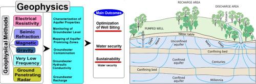
Groundwater is a hidden yet vital for life sustainable resource for billions across the world. However, it is often overlooked despite accounting for over one-third of global freshwater supplies. Geophysics plays a critical role in exploring, developing, and sustaining groundwater resources. This review article provides an in-depth analysis of the various roles of geophysics in groundwater development and sustainability, highlighting the importance of geophysical methods in mapping subsurface structures, characterizing aquifer properties, monitoring groundwater levels, detecting contamination, optimizing well siting, and assessing groundwater recharge processes. It also examines the transformative power of geophysical techniques, highlighting their effectiveness in mapping aquifer properties such as thickness, depth, volume, hydraulic conductivity, flow pathway, faults, and fractures to monitor groundwater levels and assess aquifer potential and vulnerability. Case studies demonstrate the efficacy of geophysical methods in groundwater studies across the globe. For instance, electrical resistivity (ER) surveys have been employed to identify promising aquifer zones with relative resistivity values ranging from 10 Ωm to 500 Ωm and transmissivity values ranging from 0.79 to 1203 m²/day, occurring with depths of . Seismic surveys have accurately delineated aquifer depths from 24 to 150 m Furthermore, geophysical techniques have been instrumental in detecting and delineating groundwater contamination plumes, with studies revealing low resistivity zones (<15 Ωm) associated with contaminant plumes. The limitations and strengths of geophysical methods were also discussed alongside the other methods, such as geological observation, hydrogeological survey, test drilling, remote sensing (RS), and tracing its evolution from the era of blind exploration. While challenges exist, the future of groundwater management hinges on the continued development and application of geophysical methods. By integrating these techniques with the insights from hydrogeological and other methods, we can optimize well-siting, enhance aquifer recharge, and ensure long-term sustainable groundwater resource management (GWRM). This study underscores the vital role of geophysical methods in bridging the gap between knowledge and action, paving the way for a water-secure future.
地下水勘探、管理策略和可持续性:地球物理方法
地下水是一种隐藏但对全球数十亿人的生命和可持续资源至关重要的资源。然而,尽管它占全球淡水供应量的三分之一以上,却经常被忽视。地球物理学在勘探、开发和维持地下水资源方面起着至关重要的作用。这篇综述文章深入分析了地球物理在地下水开发和可持续性中的各种作用,强调了地球物理方法在绘制地下结构、表征含水层性质、监测地下水位、检测污染、优化井址和评估地下水补给过程中的重要性。它还考察了地球物理技术的变革力量,强调了它们在绘制含水层属性(如厚度、深度、体积、水力传导性、流动路径、断层和裂缝)以监测地下水位和评估含水层潜力和脆弱性方面的有效性。案例研究证明了地球物理方法在全球地下水研究中的有效性。例如,电阻率(ER)测量已被用于确定有前景的含水层,其相对电阻率值为10 Ωm至500 Ωm,透射率值为0.79至1203 m²/天,发生深度≥5m。此外,地球物理技术在探测和圈定地下水污染羽流方面发挥了重要作用,研究揭示了与污染羽流相关的低电阻率带(<15 Ωm)。讨论了地球物理方法的局限性和优势,以及地质观测、水文地质调查、试钻、遥感(RS)等其他方法,并追溯其从盲目勘探时代的演变。尽管存在挑战,但地下水管理的未来取决于地球物理方法的持续发展和应用。通过将这些技术与水文地质学和其他方法相结合,我们可以优化井位,增强含水层补给,并确保长期可持续的地下水资源管理(GWRM)。这项研究强调了地球物理方法在弥合知识和行动之间的差距、为水安全的未来铺平道路方面的重要作用。
本文章由计算机程序翻译,如有差异,请以英文原文为准。
求助全文
约1分钟内获得全文
求助全文

 求助内容:
求助内容: 应助结果提醒方式:


