Antonio Vidal-Llamas, Carolina Acuña-Alonso, Xana Álvarez
{"title":"Past and Present in the Ecological Connectivity of Protected Areas Through Land Cover and Graph-Based Metrics","authors":"Antonio Vidal-Llamas, Carolina Acuña-Alonso, Xana Álvarez","doi":"10.1007/s00267-025-02206-1","DOIUrl":null,"url":null,"abstract":"<div><p>Habitat reduction is significantly threatening biodiversity, making ecological connectivity which facilitates species movement across habitat patches, essential for human impacts mitigation, promoting genetic exchange, and enabling colonization of new areas. Ecological connectivity in the River Lérez Basin (Galicia, NW Spain), including three Natura 2000 sites: River Lérez, Serra do Cando, and Serra do Candán, was assessed. Land cover maps for the years 2013 and 2023 were created using Landsat 8-9 images and the random forest machine learning method. Hardwood forest habitat patches and ecological corridors were identified. Betweenness Centrality (BC) metric, along with other global structural connectivity indices such as Integral Connectivity Index (IIC), Connectivity Probability (CP), and Equivalent Connectivity (EC), were calculated. iNaturalist records were then downloaded to observe how the distribution of records resembled that of habitat and corridors for 2023. Some indices, such as the splitting patch index (SPLIT), effective meshsize (EM), edge length (EL), and edge density (ED), were also calculated at the patch level. Results showed that the area of hardwoods increased by 2.16% across the basin. The spatial patch patterns were similar in both years. Additionally, hardwood structural connectivity appeared to have improved over the study period, with IIC rising in 20.00%, PC increase by 16.67–18.92%, and EC 8.04–8.68%. However, some patches from 2013 had higher BC values due to the loss of certain connections. iNaturalist record distribution showed similarities with habitat patch and path distribution, with a lower average distance (406.06 m) compared to random points (854.12 m) for 2023. The patch indices indicated a reduction in fragmentation, with SPLIT decreasing by 53.95%, EM and EL increasing by 173.66% and 14.21%, respectively, while ED decreased by 9.29%. The integration of satellite imagery has been proven effective for generating land cover data for connectivity analysis. It also demonstrates that indices and graph-based approaches offer a data-efficient alternative to traditional models. Furthermore, the incorporation of citizen science platforms, despite some biases, complements technical methods by providing real-world insights into species distribution. This combination is considered a promising approach for future research.</p></div>","PeriodicalId":543,"journal":{"name":"Environmental Management","volume":"75 8","pages":"2116 - 2135"},"PeriodicalIF":3.0000,"publicationDate":"2025-06-17","publicationTypes":"Journal Article","fieldsOfStudy":null,"isOpenAccess":false,"openAccessPdf":"https://www.ncbi.nlm.nih.gov/pmc/articles/PMC12259746/pdf/","citationCount":"0","resultStr":null,"platform":"Semanticscholar","paperid":null,"PeriodicalName":"Environmental Management","FirstCategoryId":"93","ListUrlMain":"https://link.springer.com/article/10.1007/s00267-025-02206-1","RegionNum":3,"RegionCategory":"环境科学与生态学","ArticlePicture":[],"TitleCN":null,"AbstractTextCN":null,"PMCID":null,"EPubDate":"","PubModel":"","JCR":"Q3","JCRName":"ENVIRONMENTAL SCIENCES","Score":null,"Total":0}
引用次数: 0
Abstract
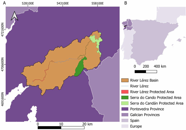
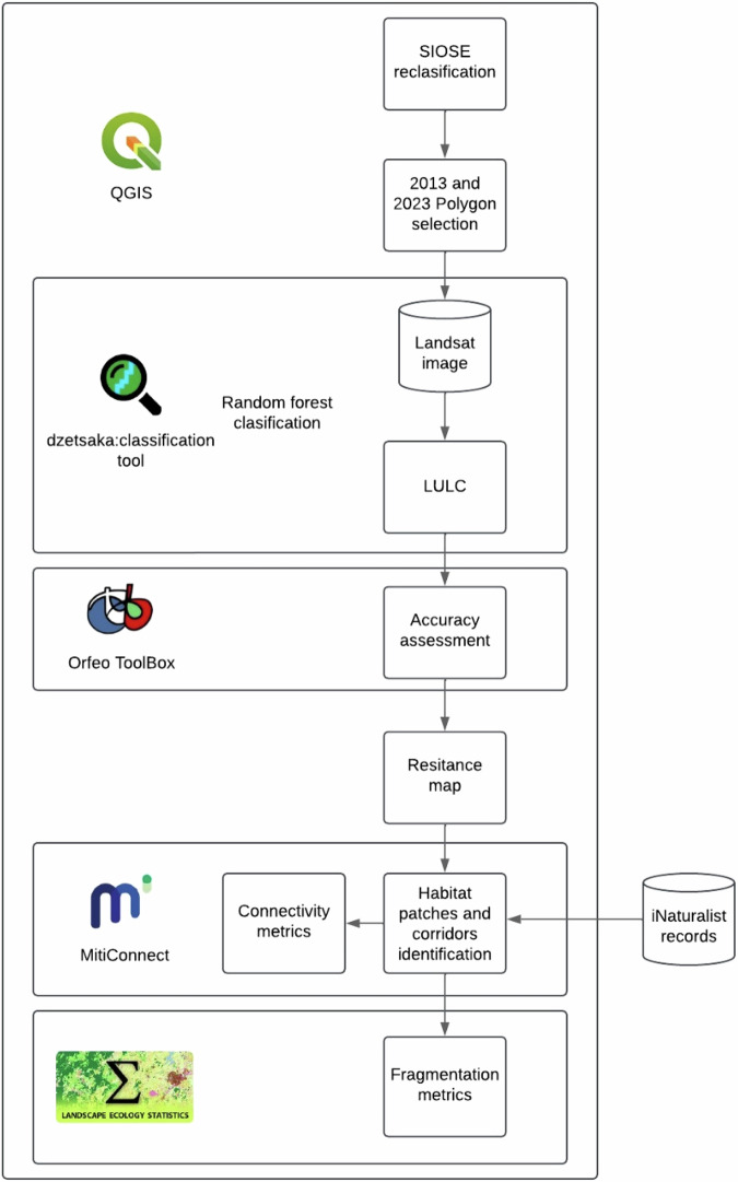
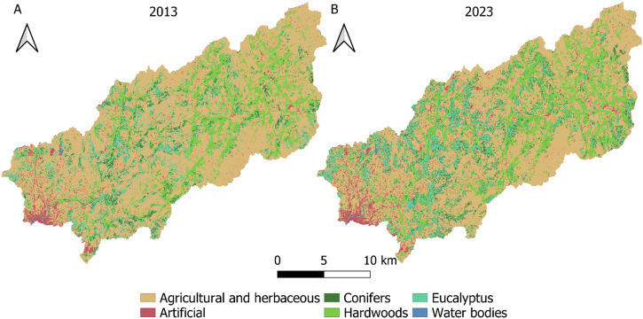
Habitat reduction is significantly threatening biodiversity, making ecological connectivity which facilitates species movement across habitat patches, essential for human impacts mitigation, promoting genetic exchange, and enabling colonization of new areas. Ecological connectivity in the River Lérez Basin (Galicia, NW Spain), including three Natura 2000 sites: River Lérez, Serra do Cando, and Serra do Candán, was assessed. Land cover maps for the years 2013 and 2023 were created using Landsat 8-9 images and the random forest machine learning method. Hardwood forest habitat patches and ecological corridors were identified. Betweenness Centrality (BC) metric, along with other global structural connectivity indices such as Integral Connectivity Index (IIC), Connectivity Probability (CP), and Equivalent Connectivity (EC), were calculated. iNaturalist records were then downloaded to observe how the distribution of records resembled that of habitat and corridors for 2023. Some indices, such as the splitting patch index (SPLIT), effective meshsize (EM), edge length (EL), and edge density (ED), were also calculated at the patch level. Results showed that the area of hardwoods increased by 2.16% across the basin. The spatial patch patterns were similar in both years. Additionally, hardwood structural connectivity appeared to have improved over the study period, with IIC rising in 20.00%, PC increase by 16.67–18.92%, and EC 8.04–8.68%. However, some patches from 2013 had higher BC values due to the loss of certain connections. iNaturalist record distribution showed similarities with habitat patch and path distribution, with a lower average distance (406.06 m) compared to random points (854.12 m) for 2023. The patch indices indicated a reduction in fragmentation, with SPLIT decreasing by 53.95%, EM and EL increasing by 173.66% and 14.21%, respectively, while ED decreased by 9.29%. The integration of satellite imagery has been proven effective for generating land cover data for connectivity analysis. It also demonstrates that indices and graph-based approaches offer a data-efficient alternative to traditional models. Furthermore, the incorporation of citizen science platforms, despite some biases, complements technical methods by providing real-world insights into species distribution. This combination is considered a promising approach for future research.
栖息地的减少严重威胁着生物多样性,促进了生态连通性,促进了物种在栖息地斑块间的迁移,这对减轻人类影响、促进基因交流和使新地区的殖民化成为可能至关重要。对lsamurez河流域(西班牙西北部加利西亚)的生态连通性进行了评估,包括三个Natura 2000站点:lsamuurez河、Serra do Cando和Serra do Candán。2013年和2023年的土地覆盖地图是使用Landsat 8-9图像和随机森林机器学习方法创建的。确定了阔叶林生境斑块和生态廊道。计算了中间性中心性(BC)指标以及其他全球结构连通性指标,如积分连通性指数(IIC)、连通性概率(CP)和等效连通性(EC)。然后下载自然学家的记录,观察记录的分布与2023年的栖息地和走廊的分布如何相似。在斑块水平上计算了分割斑块指数(SPLIT)、有效网格大小(EM)、边缘长度(EL)和边缘密度(ED)等指标。结果表明,全流域阔叶林面积增加了2.16%。两年的空间斑块格局相似。此外,硬木结构连通性在研究期间有所改善,IIC增加了20.00%,PC增加了16.67-18.92%,EC增加了8.04-8.68%。然而,2013年的一些补丁由于某些连接的丢失而具有更高的BC值。自然记录分布与生境斑块和路径分布相似,2023年平均距离(406.06 m)低于随机点(854.12 m)。斑块指数显示破碎度降低,其中SPLIT减少53.95%,EM和EL分别增加173.66%和14.21%,ED减少9.29%。卫星图像的整合已被证明对生成用于连通性分析的土地覆盖数据是有效的。它还表明,索引和基于图的方法为传统模型提供了一种数据高效的替代方案。此外,公民科学平台的结合,尽管存在一些偏见,但通过提供对物种分布的真实见解,补充了技术方法。这种组合被认为是未来研究的一种很有前途的方法。
期刊介绍:
Environmental Management offers research and opinions on use and conservation of natural resources, protection of habitats and control of hazards, spanning the field of environmental management without regard to traditional disciplinary boundaries. The journal aims to improve communication, making ideas and results from any field available to practitioners from other backgrounds. Contributions are drawn from biology, botany, chemistry, climatology, ecology, ecological economics, environmental engineering, fisheries, environmental law, forest sciences, geosciences, information science, public affairs, public health, toxicology, zoology and more.
As the principal user of nature, humanity is responsible for ensuring that its environmental impacts are benign rather than catastrophic. Environmental Management presents the work of academic researchers and professionals outside universities, including those in business, government, research establishments, and public interest groups, presenting a wide spectrum of viewpoints and approaches.
 求助内容:
求助内容: 应助结果提醒方式:


